https://journals.ametsoc.org/doi/abs/10.1175/1520-0450(1982)021<0751:HRVACF>2.0.CO;2
Most Likely Horizontal Roll Vortices
Most Likely Horizontal Roll Vortices
Last edited:
https://journals.ametsoc.org/doi/abs/10.1175/1520-0450(1982)021<0751:HRVACF>2.0.CO;2
Most Likely Horizontal Roll Vortices
I just got back from the barrens.
I should have explained that. No I followed the road down and went over the Brideg on Stevenson road at Sims Place but the fire dowve into the woods and did not go all the way to the bridge,i picked it back up on Stevenson further east so I assumed that was about the border.I drew the track.it's not from actually holding a gps. I had decent clothes on and Momma swears charcoal won't come out and i was nt allowed to hike and no bajaing either.I"m laid off in a few weeks and I want to get to the rock pile and the overlook just north of it,.It was too tight for her so I stopped.I"ll just hike there from Long causeway when I"m laid off.I"ll have to wear old clothes, she doesn't like my pine barrens pinstripes on my wearing apparel.Al, that solid blue line shows you crossed the Papoose there? No, right?
Momma started hyperventilating.I don't know why.We had 240lbs of dog with us and plenty of water so we could have lived for a couple weeks on that alone.

Interesting theory, thanks. I figure the wind is a factor as the "streets" appear wind directional. Al made same observations I've noticed with unburnt areas or trees after a major wildfire. You can usually tell where backfires have been set so I don't this is a possibility.https://journals.ametsoc.org/doi/abs/10.1175/1520-0450(1982)021<0751:HRVACF>2.0.CO;2
Most Likely Horizontal Roll Vortices
We just need to find the web source of this to get a larger view.
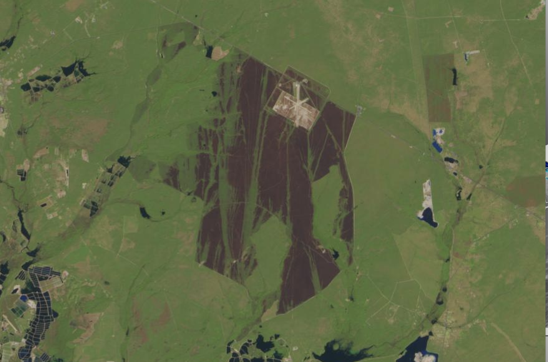
I just got back from the barrens. The pic shows what is the southern edge of the fire. I tried to go up Sooy to 72 but didnt make it all the way.Momma did not want to baja and there were some nasty holes.I then turned east on Long Causeway after back tracking and went as far as Papoose headwaters.Again a baja to cross.I know it;'s solid but it looked scary and Momma started hyperventilating.I don't know why.We had 240lbs of dog with us and plenty of water so we could have lived for a couple weeks on that alone. The southern boundary I also drove.This fire is weird.Many large areas crowned and burnt the trees totally black and are very open now then right next to them you might have an area where only the lower needles are browned and in some cases there will be a patch untouched.I remember looking into a good toasted spot where most trees lived but were black to twenty feet off the ground and 30 ft off the road a leg sixed oak was totally untouched.No soot at all surrounded by blackened pines.I did not continue further up the red road then my track but I assume the fire was checked there probably all the way to 72? I intend on doing some hikes into the fire in a couple weeks.I tried to punch north of the long causeway on a road I use to follow to Coyle Field but it was even tighter then I remember and their a few small trees lying scorss it in the beginning that I could easily run over but I heard Mommas heavy breathing again. I frequently joke about eating the dogs and she knows ai have a healthy appetite and will eat about anything.I thinks she's really afraid to let me miss a meal.Hey! Works for me! And she surely doesn't want to break down with no food in the car except of course her dogs.
A very interesting theory being thrown into the mix citing possible eco-terrorism against the "endure" riders ???
A far-fetched theory indeed 46er.That would be bringing the disagreement to a whole new level. I don't believe anyone could be that stupid, well maybe...………….
Now we have possible suspects.