5 charged with setting bonfire that ignited forest fire that burned 11K acres of N.J. Pinelands
The Spring Hill Fire burned in Penn State Forest, in Woodland Township, starting in March 2019.

It said "escaped private land" Well, that gravel pit, the one I think it is, was thought to be Haines until he had his land resurveyed.The bonfire was on private land? That's interesting.
It said "escaped private land" Well, that gravel pit, the one I think it is, was thought to be Haines until he had his land resurveyed.
You replied before I was able to correct myself. https://maps.njpinebarrens.com/#lat=39.76769215075598&lng=-74.44618541400908&z=18&type=hybrid&gpx=What do you mean by that? Do you think he thought he owned it but really does not? Do you know who does?
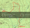
https://maps.njpinebarrens.com/#lat=39.76769215075598&lng=-74.44618541400908&z=18&type=hybrid&gpx=
This is the overlook on top of Spring Hill.
Guy, I think we talked about this, "unknown or null" The state maps which are dependent on the township records are grossly not updated. For example, a lot of land that was previously Sim Place, which is now Haines shows null or unknown.I'm sure Haines gave the townships copies of his land including Sim Place, why hasn't it been recorded? I'm sure the towns collect taxes.I have the text version of the complete Haines survey. However, there are major errors in it and because of that I can't proceed beyond a certain point or I would be able to say yes or no from my point of view. The state tax records show the owner of that pit to be "unknown."
Yes, it is, if you've not been there it's worth the trip on a clear day. Haines Sr used to sit in his truck for hours just looking over the forest, so I'm told.That little white spot is an overlook? I never knew that.
Yes, it is, if you've not been there it's worth the trip on a clear day. Haines Sr used to sit in his truck for hours just looking over the forest, so I'm told.
Spring Hill is at the top of the pit and it is quite a nice view. I'm sure many have been there.
")
Bob, have you ever been here? https://maps.njpinebarrens.com/#lat=39.77107783650873&lng=-74.44335472313464&z=19&type=nj2015&gpx=I always knew where it was. The gravel pit is often cited because it's the main representation of the area. I had a PBX exploration that would go to the actual point on the topo, but knowing how hard it is to beat through the pygmy pines in that area, I decided to not do it. All the guys would be pissed at me.

Boyd, so Spring Hill is more of a range than the actual hill? Yes, I always thought the gravel pit was the actual Spring Hill, especially since the road is named Spring Hill rd. Any idea of why the topo doesn't show the gravel pit?
Bob, have you ever been here? https://maps.njpinebarrens.com/#lat=39.77107783650873&lng=-74.44335472313464&z=19&type=nj2015&gpx=
There's an old enduro trail going over the top. Unfortunately, the trees are large and there is nothing to see. Maybe now you can see a little because of the fire, but the satellite map looks like the fire didn't burn much there. Click on the topo to see the steepness.
Bob, on your hike, were you on Spring Hill rd on your way back? While the rd is not the advantage point, I'm surprised nobody noticed the elevation. I guess you had everybody beat into submission and all were looking for the tailgate party at the conclusion,