Don Catts, very nice job with the map. Do you intend to publish it?Ed,
Sorry this is the best I can do with this camera. Is there a rule about disclosing exact locations on this forum? You can't get anymore exact than these locations. If there is Guy or myself will delete this post.
View attachment 5843

Atsion: Old and Renewed
- Thread starter Jerseyman
- Start date
You are using an out of date browser. It may not display this or other websites correctly.
You should upgrade or use an alternative browser.
You should upgrade or use an alternative browser.

Don Catts, very nice job with the map. Do you intend to publish it?
Thanks Tracker Jim, for the compliment.
I did not intend to publish it, don't think there is much of a demand for a Historic Map of Atsion, just made it for my own personal use.
Actually I intended to hang it in the restored Mill Race House/Race House (sometimes call the Lane House) at Atsion. Last fall I attended an onsite meeting between the PPA, Wharton Super. and the local Historical Society, where the PPA expressed an interest in restoring the Race House along with some of the historic sites in the area. I believe they intended to use the Race House for canoe rentals along with presenting the history of the area. After the meeting Lost Town Hunter, who was also there, and I took a quick tour of the Cotton Mill Ruins. .
If I am correct, after the PPA bought the Adams Canoe business last January, the Race House idea was dropped or put it on hold. I stopped at the PPA Canoe Rentals on Atsion Road and it did not look very history oriented so I dropped the idea altogether.
David Robbins, superintendant at Atsion, expressed an interest in hanging it in the Range Station. However, you are dealing with the state, and although the frame did not come out as well as I had hoped, I did make it and would want it back if it were taken down and not have it stored in the attic or the basement of the mansion.
Don
Thanks Don. That's a really nice map that pulls the area together.
Thanks Ed,
As I said compliments are always welcome. If there is an area you want to check out, I can zoom in for you.
Don
I would love to see it zoomed in. I can't read the captions.On the whole map.On the smaller section you posted first I can but the sections that weren't included in that I can't read.
I agree. Cool mapI would love to see it zoomed in. I can't read the captions.On the whole map.On the smaller section you posted first I can but the sections that weren't included in that I can't read.
I would love to see it zoomed in. I can't read the captions.On the whole map.On the smaller section you posted first I can but the sections that weren't included in that I can't read.
Starting at the bottom of map and going right to left up the map.
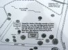
Guy, Ben, or anyone if you think I am giving up to much information it's no problem to delete the posts.
This area wasn't clear.

This area wasn't clear.
Thanks Don! It looks like a few foundations I"ve missed in here. I went looking for the Grist Mill once and was right along the road where you show it is under the road. I found a large sandstone boulder in there and was told it was part of the Grist Mill. Do you know if this true? Also what is the large piece of what appears to be slag immediately behind the parking area at the Canoe launch and on the other side of the ditch (Tail Race). This really an awesome map. It is very artistic and appears to be in scale as well.
Thanks Don! It looks like a few foundations I"ve missed in here. I went looking for the Grist Mill once and was right along the road where you show it is under the road. I found a large sandstone boulder in there and was told it was part of the Grist Mill. Do you know if this true? Also what is the large piece of what appears to be slag immediately behind the parking area at the Canoe launch and on the other side of the ditch (Tail Race). This really an awesome map. It is very artistic and appears to be in scale as well.
Al, that Grist Mill was extra large and three stories of stones, so I guess they used some very large stones (boulders). Any stone in that area probably came from the Grist Mill or maybe from the original forge itself. Today there is not much left. When they put the silt fence up to rebuild the dam they augured holes right down the wall of the Grist Mill. See photos.
As for the slag ball behind the cotton mill, there is not much left of that either. It's in several pieces. Folks just keep on chipping away at it.
It is a wonderful map.
I agree. Very nice job Don!
Like Milmay's "Cannon Range" tract,
Atsion also was a proving ground candidate, but deemed too swampy.

Atsion also was a proving ground candidate, but deemed too swampy.
Like Milmay's "Cannon Range" tract,
Atsion also was a proving ground candidate, but deemed too swampy.
Spung-Man, interesting report. Not just Atsion, but the whole book. Pretty actuate description of the Atsion property, definitely to swampy for what they were looking for. To bad they didn't buy it, some of the old buildings may have been restored and still standing today.
One thing in the description I find interesting, they say the owner lives in the mansion. That would be Walter J. Raleigh, son of Maurice. Walter moved into the mansion when Maurice Raleigh bought the Atsion property May 11, 1871, or shortly thereafter. It looks like he lived there until Joseph Wharton bought it on May 1, 1892. Walter was secretary for the Raleigh Land & Improvement Company when it formed Feb 10, 1885. He was also in charge of sales for the Town of Raleigh and the Town of Waterford and worked out of the mansion.