Atsion: Old and Renewed

RednekF350

Piney
Feb 20, 2004
5,054
3,327
Pestletown, N.J.
Guy,
Amato's flooded because the State or the Millers raised the road in front of it about two feet in elevation about twenty five years ago. I remember it distinctly. We used to pick blueberries from the rows near the house when my kids were little. After the fill work, the area around the house stays saturated almost all year.
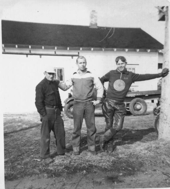
Remember this picture ? Looks okay back then. Dave on the left and Y-Buc Bill on the right.
 
Last edited:

Teegate

Administrator
Site Administrator
Sep 17, 2002
25,951
8,694
then and now Dave Amato.jpg
 

Teegate

Administrator
Site Administrator
Sep 17, 2002
25,951
8,694
Guy,
Amato,s flooded because the State or the Millers raised the road in front of it about two feet in elevation about twenty five years ago. I remember it distinctly. We used to pick blueberries from the rows near the house when my kids were little. After the fill work, the area around the house stays saturated almost all year.
Remember this picture ? Looks okay back then. Dave on the left and Y-Buc Bill on the right.


I now remember you saying that before.
 
Last edited:

Spung-Man

Piney
Jan 5, 2009
1,000
729
65
Richland, NJ
www.researchgate.net
DC,

Really enjoying the thread! So in 1895 the name Middle Road is used for the Dutchtown portion of Route 206, and Middle Road begins at a suspected tavern near Desolation Pond. Wouldn't that course just about put the roadway in the middle of the Atsion Lands?
 

Teegate

Administrator
Site Administrator
Sep 17, 2002
25,951
8,694
I suspect this was before he lived in the house in the above photos.
 

Don Catts

Explorer
Aug 5, 2012
465
274
85
Indian Mills
DC,

Really enjoying the thread! So in 1895 the name Middle Road is used for the Dutchtown portion of Route 206, and Middle Road begins at a suspected tavern near Desolation Pond. Wouldn't that course just about put the roadway in the middle of the Atsion Lands?


Although, Dave was born in 1895 his WWI draft card was filled out in 1917 when he was 21 years old.

The previously unnumbered highway was designated Route 39 in 1927. The Route 39 designation was changed in 1953 to US 206. Although, it was unnumbered until 1927 the road must of had a name even if it was just a local name and Middle Road is as good as any. It is a continuation of Middle Road and it is located right up the middle. So it is possible it was called middle Road up until 1927. However, I believe he was living on Middle Road in Hammonton City at the time. His family owned a fruit farm on Middle Road in Hammonton City.
In 1942 when he filled out the WWII registration card he and his brother John are still living at Middle Road, Hammonton, but his place of business is now Route 39.

I also notice in 1940 David is lodging with Samuel & Alberta Cavileer, who lived next to George & Annie Cavileer in Dutchtown proper (if you will) on Route 39, at this time he is caretaker of his own cranberry bogs.

Don
 

Oriental

Explorer
Apr 21, 2005
257
147
Don,

Do you remember the house just south of Dutchtown but on the west side of the highway ?
Scott

I have seen an old map (1938 but redrawn from a 1906 map) which identifies that house as the "Hammonton House". Presumably it was associated with the Hammonton Cranberry Company that had the adjacent bogs that straddled both sides of 206. The same map shows only two structures in Dutchtown. One is the D.F. Morrell Farm House and the other is identified as a Pickers House.

I am also very curious about the history of the three or four structures that stood on the south side of Park Avenue right near 206. The ruins can be easily located as they are very near the road. I am guessing they were once associated with one of the nearby bog properties but would love to know for sure.

http://apps.historicaerials.com/api/layers/1940/17/38324/49755?ETag=0
 
  • Like
Reactions: Don Catts

Don Catts

Explorer
Aug 5, 2012
465
274
85
Indian Mills
I have seen an old map (1938 but redrawn from a 1906 map) which identifies that house as the "Hammonton House". Presumably it was associated with the Hammonton Cranberry Company that had the adjacent bogs that straddled both sides of 206. The same map shows only two structures in Dutchtown. One is the D.F. Morrell Farm House and the other is identified as a Pickers House.

I am also very curious about the history of the three or four structures that stood on the south side of Park Avenue right near 206. The ruins can be easily located as they are very near the road. I am guessing they were once associated with one of the nearby bog properties but would love to know for sure.

http://apps.historicaerials.com/api/layers/1940/17/38324/49755?ETag=0


Oriental

Very interesting, "Hammonton House" I would say it had to be connected to the Hammonton Bogs, it is so close.

I too have always wondered about those buildings on Park Ave. I remember the ruins of the first building. It had to be some kind of warehouse or packing house. It's walls were bog iron, a beautiful orange brown color. Every time I rode by there were more stones removed until today there is nothing left.

I am also curious about Dutchtown itself. Where exactly was it? When did it come to be and why? Were they Dutch, Were they German? I don't recall it mentioned in any of the old history books. It doesn't look like there were ever more than three or four families there at one time, but I don't know for sure?
The Federal Census, a branch of the of the Federal Government does not recognize it, they call the area Route 39, Hammonton.

Don
 

Teegate

Administrator
Site Administrator
Sep 17, 2002
25,951
8,694

Teegate

Administrator
Site Administrator
Sep 17, 2002
25,951
8,694
The property on Park drive where the buildings are in the photo Oriental posted was sold to the National Cranberry Company by Anthony Colasordo and others on May 1, 1929. The Hammonton Cranberry Company's property was just south of there. So unless it was sold to them later the buildings were not part of Hammonton Cranberry.
 

Teegate

Administrator
Site Administrator
Sep 17, 2002
25,951
8,694
And the Hammonton Cranberry and Improvement Association sold that piece to Joseph Wharton on May 2, 1881.
 

Teegate

Administrator
Site Administrator
Sep 17, 2002
25,951
8,694
And the property north along 206 above that lot says something about Joesph Cavileer Wagon Wheel???????? That would be the Dutchtown property. This map was made by the surveyors of Wharton so in the 1950s he may have had a business there called the Wagon Wheel.
 

Oriental

Explorer
Apr 21, 2005
257
147
DC,

. . . the name Middle Road is used for the Dutchtown portion of Route 206, and Middle Road begins at a suspected tavern near Desolation Pond. Wouldn't that course just about put the roadway in the middle of the Atsion Lands?

Perhaps the road was named for the Middle Branch of Great Swamp that it crosses. It is hard to tell if Middle Branch is the stream now called Cedar Brook or a smaller tributary between Cedar Brook and the main branch.

middle branch.jpg


Sorry for the quality of the image.
 
  • Like
Reactions: Teegate

Oriental

Explorer
Apr 21, 2005
257
147
The property on Park drive where the buildings are in the photo Oriental posted was sold to the National Cranberry Company by Anthony Colasordo and others on May 1, 1929. The Hammonton Cranberry Company's property was just south of there. So unless it was sold to them later the buildings were not part of Hammonton Cranberry.

I am not exactly sure what to make of this. Perhaps the land did belong to the Hammonton Company at one time. The building show up on the 1931 aerials so maybe they predate the 1929 Colasordo sale.

Hammonton Cranberry Company.jpg
 

Teegate

Administrator
Site Administrator
Sep 17, 2002
25,951
8,694
They certainly may. I have that side also. Let me check what I have.
 

Oriental

Explorer
Apr 21, 2005
257
147
Perhaps the road was named for the Middle Branch of Great Swamp that it crosses.

After I looked at the Beers map that Don posted, Middle Road seems to be just that. The middle road when Hammonton was mapped out

middle road.png


Doesn't look like it ever corresponded to Rt 206.
 
  • Like
Reactions: Spung-Man
Top