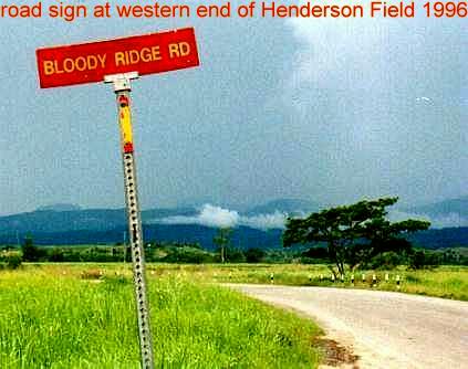
Bloody Ridge

Boyd

Administrator
Staff member
Site Administrator
Jul 31, 2004
9,826
3,005
Ben's Branch, Stephen Creek
I wandered awhile in the Pasadena Fish and Wildlife Management area today, and my Magellan GPS with the US Topo map told me I was on "Bloody Ridge Road". The Garmin GPS only showed a portion of this road and did not have a name. The DeLorme 3d Topo maps don't show a name, and neither do the USGS maps. This is a section of the road http://www.topozone.com/map.asp?z=1...ize=l&u=7&datum=nad83&layer=DRG25. It crosses over Webb Mill Branch. You can get there by turning right from Rt 539 several miles south of Whiting. Nice drive, road was in very good condition and if you follow more or less straight you end up in Bullock right where Mt. Misery Rd. meets the tracks.

Anyone have an idea where the name "Bloody Ridge" comes from. One thing that crossed my mind as I hiked around at sunset, the setting sun looked very red on the trees along the ridge. Perhaps it's just that?
 

Ben Ruset

Administrator
Site Administrator
Oct 12, 2004
7,619
1,878
Monmouth County
www.benruset.com
That's a new one to me. I suppose the "ridge" is somewhere in the area, since it looks like there's quite a bit of elevation around there.

I would imagine that it would have something to do with he revolutionary war, since there was some activity near that area.
 

WaretownMike

Explorer
Jul 16, 2013
186
100
53
Waretown
Ben, what information do you have pertaining to any battles around this area? Are you referring to what was fought in the Barnegat area?
 

Ben Ruset

Administrator
Site Administrator
Oct 12, 2004
7,619
1,878
Monmouth County
www.benruset.com
The only one I know of is the one you're thinking of - Cedar Bridge, which was more of a skirmish than an actual battle.

Since the Topozone link in Boyd's post no longer works, here's a link to it on NJPB Maps: http://maps.njpinebarrens.com/#lat=39.87220903005822&lng=-74.38710224785461&z=14&type=terrain&gpx=

It's interesting to note that Bloody Ridge Road does not show up on the historic topo map layer, which dates from 1881-1934. The road does show up in the 1930s aerial though. On Historic Aerials the map shows up on their old topos sometime between 1916 and 1942.
 

46er

Piney
Mar 24, 2004
8,837
2,144
Coastal NJ
There was a Sgt John Basilone from Manville that earned the Medal of Honor in WWII for his actions holding off 3000 Japanese on Bloody Ridge in the fight for Guadalcanal in 1942.

http://www.pacificwrecks.com/valor/moh/basilone/index.html

Bloody_Ridge_road_sign.jpg


There was also a major battle in Korea on a 'Bloody Ridge' in 1951; 'Heartbreak Ridge' was the next in line.

Perhaps one of these has something to do with the name;I would guess the first.
 

Ben Ruset

Administrator
Site Administrator
Oct 12, 2004
7,619
1,878
Monmouth County
www.benruset.com
Anything is possible, but I think that even the great state of New Jersey could come up with a better way of honoring famous battles then naming an obscure dirt road after it.

I think Boyd's idea of the trees bathed in orange and red in the sunset is the best idea so far. Unfortunately this is something we may never know.
 

Boyd

Administrator
Staff member
Site Administrator
Jul 31, 2004
9,826
3,005
Ben's Branch, Stephen Creek
Funny to see this old thread get revived after so many years. I started it about a week after I joined NJPB. And, come to think of it, today is my 9th anniversary as a member (although I was a lurker before that). :)
 
  • Like
Reactions: Ben Ruset
Top