can you help me find these ruins?
- Thread starter pines rider
- Start date
You are using an out of date browser. It may not display this or other websites correctly.
You should upgrade or use an alternative browser.
You should upgrade or use an alternative browser.


"Guy
Isn't that the foundation of the house the last person that lived in Friendship lived in?The woman you told me you talked to back in the 70"s?
Al "
Are these the ruins that have the cement slab/concrete blocks (as opposed to the ones with stacked rocks etc) and what looks to be an oil/propane tank' pipe sticking up out of the ground? Seemed it was the newest foundation over there
... Also, are there any good maps of the trails? google maps has some but theyre hard to print.
Years ago, when i used to haunt the PB, I used geological survey maps. My last adventure - or rather misadventure! - was about eight years ago, and then I was using my Garmin GPS map which was surprisingly good - and wound up saving me about $20,000, but that's another story!
I have posted some very detailed free maps for Garmin units here: http://www.gpsfiledepot.com/maps/byuser/282/. Some of them are scans of USGS maps and there are also high resolution aerial images, but these maps only work on the newest Garmin handhelds.
This one has a much higher level of detail than any other map that you're likely to find for the pines. I am currently working on an updated version and will post when it's available, which should be pretty soon: http://www.gpsfiledepot.com/maps/view/294/
This one has a much higher level of detail than any other map that you're likely to find for the pines. I am currently working on an updated version and will post when it's available, which should be pretty soon: http://www.gpsfiledepot.com/maps/view/294/
Hi everyoneThanks for having me...Im relatively new (well, renewed. Not roamed the pb since I was 17 or so. Now Im 41 today) to the Pine Barrens. I just had a few questions. The abandoned water tower (next to the rr tracks)on Savoy rd off rt 72 near Woodland twp. Can anyone tell me what this place wase (the wide flat field that looks like a former strip mining/sand pit). Also, are there any good maps of the trails? google maps has some but theyre hard to print.
The water tower on Savoy Blvd was part of the old Pioneer Smelting plant. I took a few pics in 2004 before they tore down the buildings:
http://gallery.njpinebarrens.com/showgallery.php/cat/514
Boyd, I came across your GPS mapping when I was scanning this great website the other night. I was awfully impressed. I've used GPS for years going back to the Garmin II. But I've never learned how to use any non-Garmin maps. I have the 276C now and I've been following the reviews for the new Montana model. My Garmin II+ saved me about $20,000 - the cost of a rented car - when I - uh - lost it in those woods about eight years ago.
Thanks!! I thought a sand quarry or smthn...thanks for letting me knowThe water tower on Savoy Blvd was part of the old Pioneer Smelting plant. I took a few pics in 2004 before they tore down the buildings:
http://gallery.njpinebarrens.com/showgallery.php/cat/514
Do you have them? Is that member still here? If so could you scan them?
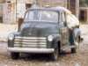
Did you see writing on the side of the truck? I just looked again, and think you're right. I also wanted to see what it's loaded with, and what's propped against the tree on the left. It looks like an old refrigerator.
Did you see writing on the side of the truck? I just looked again, and think you're right. I also wanted to see what it's loaded with, and what's propped against the tree on the left. It looks like an old refrigerator.
Do you have them? Is that member still here? If so could you scan them?
Did you see writing on the side of the truck? I just looked again, and think you're right. I also wanted to see what it's loaded with, and what's propped against the tree on the left. It looks like an old refrigerator.
She is still a member and pops in once in a while. I do not have the photo's. She had them in an album and we walked the property and stood at the locations where they were taken. We were looking for a sawmill her relatives told her was out there nearby, but we did not find it where they told us to go.
The truck does have lettering but it may be hard to read even when zoomed in. But I have been successful doing it on a few postcards I acquired. But with it on an angle it may be impossible to see.
Guy
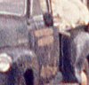
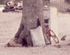

Blowup of truck lettering. Also sharpened.
Thanks for blowing it up. It appears it is not going to help us but looking closely at the second word the first letter may be an A. If it was it may be Albert Andrews. However, the first word looks longer than Albert so I doubt that is what it says. I am not good with ages of trucks or we may be able to run that out completely. Andrews sold the property in the 50's. Then it became Friendship Forest Lakes which was a development company.
Guy