Crews Battling Wildfire Along Mullica River in South Jersey’s Wharton State Forest

stiltzkin

Explorer
Feb 8, 2022
540
807
Medford
Also check this out, if you want an interactive map:


Set the parameters to at least 10 days ago to see the full extent of the fire.

This data comes from the same source (VIIRS, which is a sensor on a NOAA satellite).
 
  • Like
Reactions: teleflux and Boyd

Wildland937

Scout
Aug 24, 2016
63
36
New Germany
Back when the original MAP was being discussed they could have closed every road in Wharton and it wouldn't have really affected me. At the time, I drove a 2013 Ford Taurus, which kept me pretty much out of the woods in and of itself. However I fought really, really hard against it because it would affect a lot of other people that I know and care about and also because it was such a massive change in the status quo that was planned in secret between the Wharton Superintendent and the PPA and I was opposed to that on ethical reasons.

Sometimes you have to stand up against things that are wrong, even though you're not inconvenienced by them.
Understandably so. I was affected too, but the power of conversation and getting real facts is an amazing thing. Everyday speculation and made up nonsense runs wild and ends up getting twisted into ridiculous notions. People should try going to a source of the unexplained more...
 

imkms

Explorer
Feb 18, 2008
603
242
SJ and SW FL
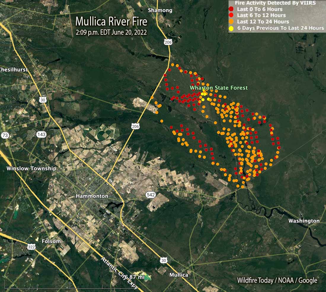
Satellite view of the fire
1656613050024.png
 

openwoods

New Member
Apr 22, 2013
11
9
Thanks for posting the satellite view of the recent fire. Looking at the image it appears that there were 2 separate fires? It looks like the 1 fire started near the camping area (recently established by the owner of paradise lake) on the northeast side of paradise lake? Wind was northwest that weekend.
 

Teegate

Administrator
Site Administrator
Sep 17, 2002
25,951
8,695
I think they were concerned the fire would make it to Paradise Lake so they back burned putting an end to that issue.
 

dragoncjo

Piney
Aug 12, 2005
1,574
298
43
camden county
Bob I think you are right based on my walking the area. I also feel like much of this was a real hot backfire because fear of winds at that time. I didn’t see much scorched earth when I was out.
 
  • Like
Reactions: bobpbx

smoke_jumper

Piney
Mar 5, 2012
1,606
1,164
Atco, NJ
I want to start off by saying I was’t there but I can kind of guess how the fire progressed. With the ignition point on the Mullica in the vicinity of Locks bridge and I believe the wind was north west the fire would have progressed to the south and east widening as it went. Once it crossed the Sleeper the only viable fire break would have been West Mills. Most of the green interior are areas where the ground is still wet or at least damp and wouldn’t support a hot fire.
 

Teegate

Administrator
Site Administrator
Sep 17, 2002
25,951
8,695
I want to start off by saying I was’t there but I can kind of guess how the fire progressed. With the ignition point on the Mullica in the vicinity of Locks bridge and I believe the wind was north west the fire would have progressed to the south and east widening as it went. Once it crossed the Sleeper the only viable fire break would have been West Mills. Most of the green interior are areas where the ground is still wet or at least damp and wouldn’t support a hot fire.

So you are saying that West Mill Road would have been controlled burns as I believe? This would be to eliminate problems at Paradise Lake Campground.
 
  • Like
Reactions: smoke_jumper

smoke_jumper

Piney
Mar 5, 2012
1,606
1,164
Atco, NJ
So you are saying that West Mill Road would have been controlled burns as I believe? This would be to eliminate problems at Paradise Lake Campground.
Yes, it would have been backfired ahead of the main fire and where the two meet they draw each other together and burn very hot.
 

Teegate

Administrator
Site Administrator
Sep 17, 2002
25,951
8,695
That meeting area that gets hot is where I want to go this week. I am hoping it was very hot :)
 
  • Like
Reactions: smoke_jumper

Teegate

Administrator
Site Administrator
Sep 17, 2002
25,951
8,695
It is a long walk and I am just starting to feel better. It has been a very very long week for me as well as two weeks for Jessica, and now Jennifer is suffering.
 

dragoncjo

Piney
Aug 12, 2005
1,574
298
43
camden county
I kayaked the Mullica last Sunday and in forest islands the beaver lodges were burnt in the middle of Mullica. I didn’t think it could jump the Mullica there but perhaps it did as the other side was charred completely.
 

stiltzkin

Explorer
Feb 8, 2022
540
807
Medford
What's the current status of the roads in the area? What's closed, if anything? Would like to get in for some pictures tomorrow.

Wharton Facebook page mentions closures for trails and paddling but not roads.
 
  • Like
Reactions: TommyP
Top