Cumberland County Stones

manumuskin

Piney
Jul 20, 2003
8,552
2,465
59
millville nj
www.youtube.com
I recently found out that the Cumberland County Clerks office has started posting their deeds online and they are back to 2002 so after figuring out how to search I found a bunch of them that the state has bought property since then and I started downloading deeds and plotting stones.Here are some I"ve found so far.

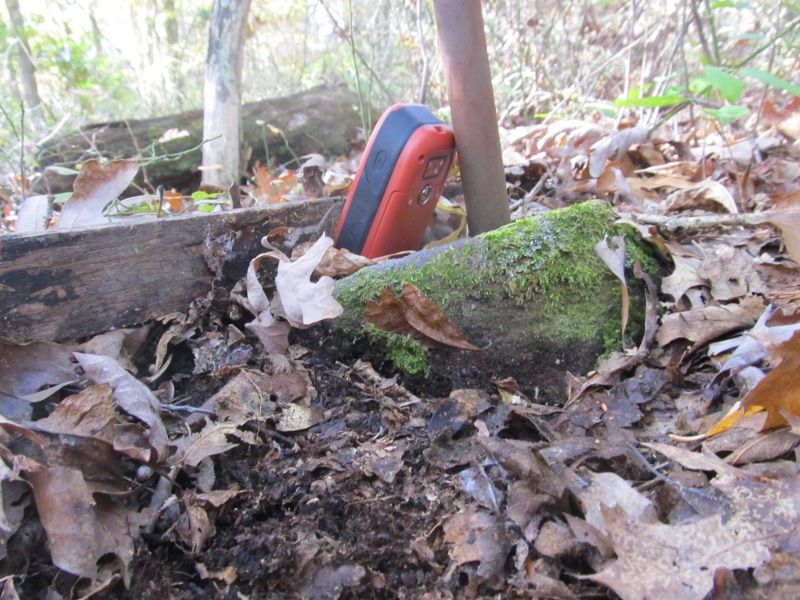
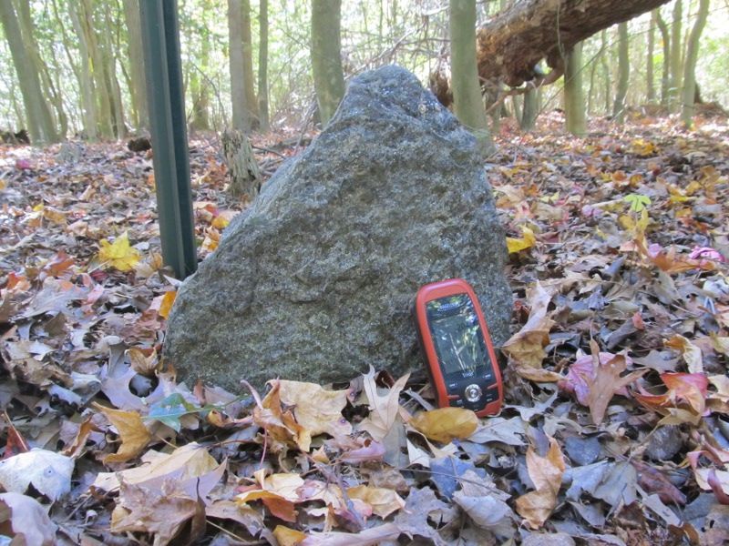
This one is right here in Laurel Lake abd I had walked within several yeards of it numerous times years ago when my Granny lived a couple hundreds yards from it and I used to be in this patch of woods all the time.

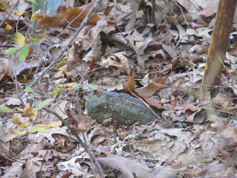
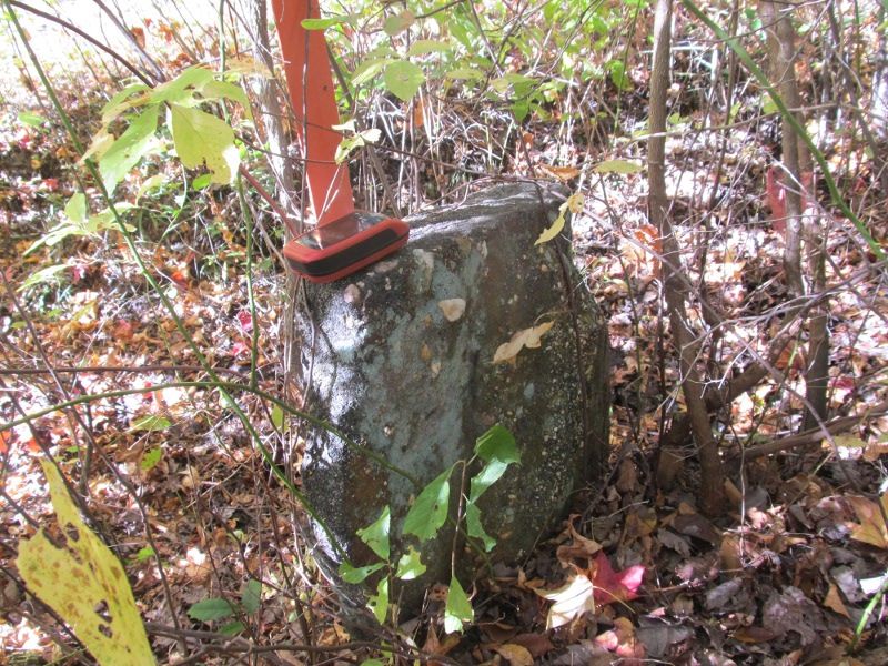
This one also in Laurel Lake was right behind someones yard and I had to zoom in on it from ten feet away because I was out in the open and they had walk in glass doors in the back of the house and if anyone had of looked out it would have looked odd me laying on the edge of their yard on my belly taking pics.I was actually on state property but it did not look good:)

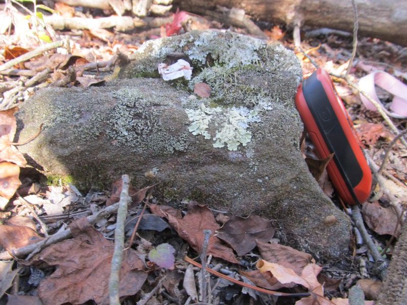
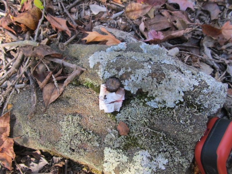
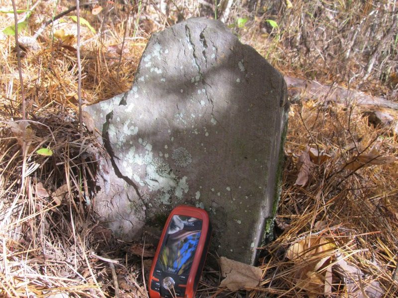
This one is just inland from Fortescue and is in some very nice open holly woods on a point extending into the salt marsh.There is a spike driven into the top,the next pic is a close up of the spike.I wonder if they drove the spike in by force which I would think would split the rock or if they drilled a hole and epoxied it in?


This one here also near Fortescue is in the most beautiful holly woods I have ever seen.Five lots meet at this stone like a star.The NC now owns four of them and one is private though I saw no posted signs.

This one here I actually had some trouble finding even though it is huge.I was trying to navigate to it and did not have my reading glasses on.I thought I had picked the waypoint I had made from the plot and I actually just picked a random spot about 200 feet from the stone.I had not zoomed the map in far enough to see much of a difference in 200 feet.When I got to my destination i spent about 20 minutes looking for what I thought must be a very small stone.I could see a line of posted signs 70 feet further east and went over and walked up and down the line,still no stone.I was just about to give up and was actually setting the gps to nav back to my truck when I noticed I was not even on the waypoint.I reset it and headed 200 feet further nw.There was the stone at the edge of a ditch down in the briars and in summer would have still been hard to find.The stone is at least five feet tall but only sticks up two feet from the top of the ditch with another three feet being visible from in the ditch.The carsonite marker is what originally attracted my attention.

And this nice stone was about 300 feet of the south end of route 55.I passed it once,circled back around as the gps settled down and found it in an open dry vernal pondnext to a tree with an NC sign on it.In very wet springs this stone would be in the water.
I still have many more to go.So far no inscribed stones but several very nice sized ones.One listed as a large granite stone I did not find but I found a ditch that made a 90 degree bend and state signs on a tree at 90 degrees to each other so i was at the corner but no stone.Possibly buried and with no poker I will have to go back.It was in the middle of nowhere and was there ten years ago so no idea what could have happened to it unless it's underground.
 

Teegate

Administrator
Site Administrator
Sep 17, 2002
25,602
8,177
Nice Al!

So now you know of two near the end of 55. I remember going there with you for the other one. It won't be long I suspect and you will find an incised one.
 
  • Like
Reactions: manumuskin

manumuskin

Piney
Jul 20, 2003
8,552
2,465
59
millville nj
www.youtube.com
I think I may know where some more will be but haven't went and looked yet.One I found by accident or I should say a buddy of minew found it while we were shrooming I thought was an old lost stone while looking yesterday at the tax lot maps realized it was still the corner of a property which means there may be stones at each corner along that line.It is a long straight line with multiple lots coming off of it with the one big property on one side nature conservancy and the multiple lots mostly private with one also being NC.Between me and my friend we have just happened on three stones out there by shear accident.
 

manumuskin

Piney
Jul 20, 2003
8,552
2,465
59
millville nj
www.youtube.com


These two stones and the next one are on NC land not far behind Leesburg Prison.Half mile bushwack to get to em.One stone I could not find.

This stone near Hunters Mill road,just lying on the ground

This stone I had found years ago.It was on the Hartman maps.It has since had a large pine log fall almost on top of it but it's propped up by limbs.

This tree is ten feet behind the stone pictured above.When I found it years ago it was alive and had orange paint in the letters.The letters were cut by chainsaw and from top to bottom are S T O N E.Almost all of the pines in this area are dead now.Could it be beetles? SHH! I don't want a desert here,let the beetles do what they will.

This stone was a back corner to Gartons property and NC property near Dorchester.I found two of his three stones,the third was so close to the house I didn't even look for it.The next stone is his other back corner.

And this final stone I almost gave up on and it was within five feet of an orange pipe and an NC sign but it was hidden under some laurel I thought I had already looked under but I looked again.I also looked for another stone 140 feet from this one that i didn't find.There was a NC sign there as well but it was laying in a tree crotch with the sign part crumpled up like paper.I thought what moron did that and then I realized at the base of a sign was a dead pine quite large.By the looks of it the pine fell and hit the sign which crumpled up the sign and sent sign and pole flying up into the tree crotch.I think the stone may be under that big log:-(
 

manumuskin

Piney
Jul 20, 2003
8,552
2,465
59
millville nj
www.youtube.com
Okay I revisited two stones today that I found last week but forgot the camera.There are supposed to be three there but the third one I could not find and suspect it may be under one of several large dead pine logs.The first one I headed to I have named the Gut Pile stone since I passed a very fresh gut pile on the way to it with blood everywhere and large amounts of corn in the guts.A very well fed deer.It may have mooed as it was shot.In any case here is the stone.

Next I proceeded 350 ft west to photograph the "Tombstone".This is a very neat stone and has varves visible on one side no doubt deposited virtually simultaneously about 4380 years ago.Here is the front side.

And here is the varve side.

Next I went to check on a stone I did no think would be there since the plot fell right on the shoulder of a county road that I have been driving or driven on literally since a baby.This stone is 200 yards from where my cousins grew up and I used to hunt snakes with them as a kid.I was all over these woods.I expected if it was there it was very small or buried.To my surprise it is knee high and plainly visible from the road.If it was small the mower would hit it but due to it's size it is very visible and I have never noticed it.I have literally been right by this stone thousands of times.I call it the "Drive By Stone"

and the back side.

Then I went to a plot of about ten stones.I found the first one and that was it.Not a sign of another stone though the location of one fell right at swamps edge so I may have been in the right place.I must replot this area.One out of ten stones is not very good.Here is the "Only Stone" because it is the only one I found.

Started snowing hard as i exited the woods.Very pretty snow in some really nice woods that were very open and strangely devoid of stones I plotted.Found many deer stands back here but thankfully none occupied.I even had on my orange beanie.I"m getting soft in my old age.I always refused to wear orange till recently since I"m not hunting.Nothing cornier then a someone clothed in camo with a florescent orange hat on their head.Hind of an oxymoron on two legs there.
 
  • Like
Reactions: Teegate and bobpbx

Teegate

Administrator
Site Administrator
Sep 17, 2002
25,602
8,177
They are interesting stones! Jessica said the one looks like Picasso's "Scream."
 

manumuskin

Piney
Jul 20, 2003
8,552
2,465
59
millville nj
www.youtube.com
Went out again today.The first stone I went for was the border between private land and NC land.Problem is the NC side is salt marsh and the only way to get to it is by boat and then a 300 ft slither across the marsh so I opted to take at a look at the private land.yep it was private.had a gated road with open gate but posted signs and hunters riding around so I opted for a return via marsh slither this spring.I then headed to another NC corner a couple miles away.I found this stone buried at ground level at the base of an NC sign but it was so dirty I took no pic since it would have been indistinguishable from the mud it was buried in.I had to scratch it to verify it was rock.Hands were too cold at this point for touch to work much.I then proceeded a couple miles west to another NC corner and this one involved either a 1200 foot trek legal like or a 400 foot trespass.I tried to go legal but was not paying attention and before I knew it I was in amongst a bunch of barrels sanding up in an open holly wood.I skedaddled quickly to an NC sign I seen in the distance and there was this at the bottom of the sign.

I then carefully retreated following pink ribbons the long way back.
I then went to a field that a stone was supposed to be in the middle of and was supposed to be state land.It was being used to grow crops and had farm equipment parked in it but had no posted signs so I drove to the back of the field.The stone was in the middle of cabbage so I did not walk 800 feet to it figuring it can't be there and did not want to walk through a cabbage crop and have to explain what i was doing if the farmer showed up.So I went to another NC property just north at the end of Easy Street.No I"m not joking it is at the end of Easy Street.It started out an 800 ft trek through nice open Virginia pines.It quickly degenerated to the thickest laurel snarl I ever encountered.No briars but laurel from hell.I finally found the stone and if I had approached from the east across private land it would have been very easy to get to since it was at the far edge of the snarl but being a law abiding citizen I took the hard way.Here it is

My next dilemma was that to the east of this stone was supposedly private but I saw no signs,just the NC sign at the stone.800 ft east was another NC lot and 400 feet past that was a stone and another 400 past that was another stone but 800 ft was from my info private.Once again no signs.If I did not come in from this way it would involve back through the snarl,a three mile drive and twice the hike in from the other side.No signs,perhaps the NC bought it?Go for it! I walked 700 feet and through very open oak woods I was an NC sign!fifty feet before I got to the sign I stepped out onto an old woods road.I looked left and right and there were signs facing back toward me.I had done the unthinkable:)I had tresspassed:)Hurry! Iran the last fifty feet and jumped behind the sign.SAFE! Hold it there was a stone at the base of the sign! I did not even have this stone plotted since the Deed did not come around this side of the property.Bonus!The Safe stone it is!

I then proceeded east and found a pile of stones where the next one was located.Nice open woods along the way.

I then went to the farthest stone 400 more feet east.I could not find it and it was in another laurel hell.I had to get home since my daughter needed a ride to a rendezvous with coworkers and did not want to leave her car at the rendezvous so I had to get out.I know the stone is there and will go back but will approach legal from the north next time.I did however have to go back across the 800 ft posted zone.I passed a stand with camera on the way back and knew I was along the line but not sure which side because this was another property,not the posted one.I think i already had been snapped before I saw the camera so what could I do.I gave my best muscle man shot(sucked in my belly best i could as well).I found out when i got home I was about 200 ft in posted land then as well.My model citizen award I know will be taken from me when that sd card is plugged in.Hey at least i didn't steal it.That was the second camera i found today and the first one was on public property.According to WMA officials their fair game since they are officially abandoned.I left that one as well.I"m a trespasser,not a thief.
 
  • Like
Reactions: Teegate

Teegate

Administrator
Site Administrator
Sep 17, 2002
25,602
8,177
Looks like you had an interesting day. Now we just need to see that muscle man shot :)
 

Spung-Man

Explorer
Jan 5, 2009
976
656
64
Richland, NJ
loki.stockton.edu
I took this picture some years back when doing geologic work with owners permission. It was along the original trace of the Mollocas (Malaga) Indian trail above the Union House, and, if memory is correct, was described as a mile stone. I'll double check with my original source.

PICT1722.jpg

S.M.
 
  • Like
Reactions: Teegate

manumuskin

Piney
Jul 20, 2003
8,552
2,465
59
millville nj
www.youtube.com
Did this old Malaga Road pass down the east or west side of Scotland Run?I think I may have walked part of it south of Weymouth Road.There is some NC land there with a hiking trail part pf which follows an old woods road.There is also an old woods road that follows Union lake down to the old Mill site on the east side of the swamp,may be a continuation of the same road?I was never aware of an old road following so close to the river,at least not a historical road the whole way between Malaga and Millville.I know that route 47 basically follows the old Hickole indian trail.Is this the actual route down the river with the modern highway being a later white man route?
 

manumuskin

Piney
Jul 20, 2003
8,552
2,465
59
millville nj
www.youtube.com
map 6 only goes as far north as Landis avenue.I on the other hand found that map 8 goes all the way to malaga.It appears route 47 in it's present route is the old Millville malaga road as it still is.So if this is along the old malaga road that lake cannot be willow Grove.I woulda swore that spot was taken from here http://maps.njpinebarrens.com/#lat=39.55394209985555&lng=-75.07084507148744&z=17&type=nj2007&gpx=
Burnt Mill Pond is not state land that I"m aware of.Cannot find Mulfords causeway.Will spread these maps out tomorrow.Mamma is watching tv and thats the only room big enough to spread these maps out in the house and it's a loud process.Can't get the west jersey sites maps to load,never can.
 

manumuskin

Piney
Jul 20, 2003
8,552
2,465
59
millville nj
www.youtube.com
Went out again today in a patch of new woods that was bought by the NC a few years back.really nice woods and quite big but to the west of me and I usually turn my attention to h larger WMA right around me or the big woods on the other side of the river in maurice river twp. or south to Bear swamp.There were four marble monuments shown to be in this woods ,I found two of them.Heres the first one.

It was perforated in both width dimensions.
Heres the next one,a different type.

I then found what looks like schist? quite sparkly

Then a nice sandstone

Then one I named the almost missed stone because it was about 30 ft off my coords.On my coords was an old blaze and I thought I had it but after about ten minutes I gave up.As I naved to the next stone about 30 ft away i walked right up to the stone I thought was a loss.

Then my luck started to run out. fond the next spot easily.A pipe,NC sign and ribbon but no stone.The next site had a monument and C sign but no s stone.Then the next spot no sign,no ribbon,nothing but as I walked i felt something wobble under my foot.t was the stone prone and covered with leaves with a bit of ribbon till stuck to it.I called it the "prone stone"

Thn my luck ran completely out.The next spot I found nothing.Then I found sign and ribbon but no stone.Then sign and ribbon on what was supposed to be a marble monument but was next to a dirt trail.Then I found an NC sign prone under leaves,I stepped on it but never did find the stone it should have been marking..I then went back to the truck and found a sign at one location then nothing at the next then at my last location I found a sign with monument and about 40 ft away I found a pile of stones in a very old road that accessed an old pit so I don't think these had anything to do with the monument 40 ft away.

 
Top