Early 1900's NJ Pine Barrens Boundary Map
- Thread starter JerseyDevil
- Start date
You are using an out of date browser. It may not display this or other websites correctly.
You should upgrade or use an alternative browser.
You should upgrade or use an alternative browser.
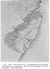
Cool to see. I'm surprised that the tidal areas of the Mullica and Great Egg Harbor Rivers aren't included south/east of Batsto and Mays Landing respectively. I can't imagine they were very industrial but they are a different ecosystem so I guess the mapmaker decided they weren't piney enough. Also interesting to see it extended into Vineland and Millville. There are pockets of pinelands down there and I assume there were more before large-scale farming.
No worries, I saw that a few minutes after commenting. Good stuff.It's explained here how the boundaries were defined, very good read. I should have put the article in the same thread. My bad.
Article
We've discussed the pinelands boundaries a number of times in the past. Here are two interesting threads, unfortunately the older posts contain dead links to sites like TopoZone (which no longer exists) and the NJPB photo gallery, which is also gone.
 forums.njpinebarrens.com
forums.njpinebarrens.com
What constitutes the Pine Barrens?
This is a spin off my other thread devoted to determining the line of demarcation between north and south Jersey. A local drunk with whom I was briefly engaged in a "debate" last week looked at me like I was from another planet when I suggested that Brick Township homes some of the Pine...
Pointing to Folsom
I know Folsom, NJ isn't QUITE in the Barrens - even though I pass a small section of Atlantic County Barrens just to get there---BUT : How on earth did Folsom get its name ?:rolleyes:
Thanks Howard. I'll be looking at that. I have asked that my accounts be merged now that I have regained access to my original account. I lost access to it many years ago when I took the JerseyDevil.com down due to all the postings of illegal activity.
I posted this thread under my replacement account. Hopefully they can merge the two to be "JerseyDevil".
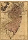
I see that thread speaks of East-West Jersey. Here's an old East-West map I have, I'm sure you probably already have it.
If this map is saved off line it enlarges pretty well.
I posted this thread under my replacement account. Hopefully they can merge the two to be "JerseyDevil".
I see that thread speaks of East-West Jersey. Here's an old East-West map I have, I'm sure you probably already have it.
If this map is saved off line it enlarges pretty well.
Attachments
Last edited:
Love the shaded terrain in that old map - even in the pine barrens. Pretty sure they didn't have LIDAR yet back then. 
Note the spelling of the "Metedeconk" river on it. yes the shading is nice.Love the shaded terrain in that old map - even in the pine barrens. Pretty sure they didn't have LIDAR yet back then.
Interesting that the area from Long Branch to Navesink (northern coastal Monmouth County) was shaded as "Pine Barrens".