Exploring The Plains Branch

RednekF350

Piney
Feb 20, 2004
4,953
3,107
Pestletown, N.J.
Here is a clip of the online deed I just pulled listing the restrictions on the property.
Unfortunately, this deed 6720/984 and the prior deed 6005/764 do not contain metes and bounds. Sold by block and lot description only. Lame.
 

Attachments

  • restrict.jpg
    restrict.jpg
    71.4 KB · Views: 248

Teegate

Administrator
Site Administrator
Sep 17, 2002
25,637
8,243
Ben's maps are the greatest. I suspect this solves the question on where the property is.

Guy
 

Attachments

  • map.jpg
    map.jpg
    54.9 KB · Views: 298

Teegate

Administrator
Site Administrator
Sep 17, 2002
25,637
8,243
I think I have the sign at the wrong place. It belongs at the road above that. It still is on the property.

Guy
 

RednekF350

Piney
Feb 20, 2004
4,953
3,107
Pestletown, N.J.
Ben's maps are the greatest. I suspect this solves the question on where the property is.

Guy
Very nice. I will still get the tax map for you. The tax map at a minimum will have the distances for each leg.
The deed restrictions on the property are taken pretty much verbatim from the Pinelands CMP.
 

Teegate

Administrator
Site Administrator
Sep 17, 2002
25,637
8,243
Thanks Scott. I would like to see that info. If you can get the info for the old gun club slightly NW of there that I have circled in yellow I would appreciate that also.

Guy
 

glowordz

Explorer
Jan 19, 2009
585
8
SC
www.gloriarepp.com
Beautiful pictures and comments from all of you . . . I'm spending a few weeks in Seattle. I like the magnificent spruce forests and rocky streams, but I cannot tell you how much I miss the sight of a ragged pitch pine or a golden savannah or rushing cedar water. Bob's notes are a plus . . . Thank you!
 

manumuskin

Piney
Jul 20, 2003
8,555
2,469
59
millville nj
www.youtube.com
I am counting on someone to figure out the 163 acre site (Al or Guy).....because I'd be awful nervous to see that pine snake and crowberry ridge camped and tramped upon.
I was thinking of that Bob but kept my mouth shut.I forgot this was the secret thread.Yes thats an area I love and thats why I drive back to the county line and park in the spot just past it and walk out to that area,I actually seen a large female pine laying in the entrance to that den.
 

manumuskin

Piney
Jul 20, 2003
8,555
2,469
59
millville nj
www.youtube.com
With any luck they'll torch the crowberry and smoke out them nasty snakes !
:D
Scott
we need to send you to serpent phobia class.They have a show on tv where people learn to overcome their fears.Perhpas you need to jump into a snake pit and I need to jump into a fire ant nest to overcome our fears.On second thought I think I understand your snake obsession a little better now :)
 

manumuskin

Piney
Jul 20, 2003
8,555
2,469
59
millville nj
www.youtube.com
Here's a map of the area including parcel information. I have used blue shading on the Boy Scouts property.

View attachment 1842
if this is the property then they are nowhere near the love shack but I do have to drive through their property to get to my parking spot.I wonder if their allowed to shut down an established sand road just because it crosses their property? I was under the imperssion their camp was the old hunting shack east of where those two side roads meet.at 50-9 on the map
 

manumuskin

Piney
Jul 20, 2003
8,555
2,469
59
millville nj
www.youtube.com
Beautiful pictures and comments from all of you . . . I'm spending a few weeks in Seattle. I like the magnificent spruce forests and rocky streams, but I cannot tell you how much I miss the sight of a ragged pitch pine or a golden savannah or rushing cedar water. Bob's notes are a plus . . . Thank you!
always wanted to see the Hoh Rainforest.You'll be right next to it.
Al
 

Teegate

Administrator
Site Administrator
Sep 17, 2002
25,637
8,243
Thanks Scott. I figured that was the property. This tells us that they only own a short distance down the road where the sign is. This also tells us that the road is a public road as Google says.

When we went by yesterday I noticed there was quite a bit of activity evidence in the dirt at the beginning of the road. It may have been from dirt bikes going down there or it may have been from the Scouts using it. They will have to make trials to get through those scrub pines which are extremely dense.

I will start a search for the property corners. if I find the corners at the road it will be very easy to find the rest.

Guy
 

1Jerseydevil

Explorer
Feb 14, 2009
567
214
Who else would beat through crap like that but a PBX member?

Stop patting yourself on the back, you'd be surprised. I think Guy may know what I'm referring to.
That "secret" area you refer to is really not so secret at all.
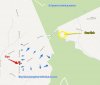
Does anyone know who and why a large front end loader went down Hallman rd, up part of the county line with it's bucket up, flattened the trees which appear to have sprung back and exit on that un-named whooped out sand road that goes back to Red rd? This was about 2 years ago.

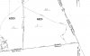
May not be of any importance for what your looking for as far as property corner stones, but there is a monument at the NW corner of Hallman rd and the county cut.

BTW, thanks for the investigation into the boy scout sign. I noticed it about mid October, had to stop, back up and stare at it scratching my head. Even then the sand around the poles looked "old", but one good rain can do that.
 

Teegate

Administrator
Site Administrator
Sep 17, 2002
25,637
8,243
That is the county line monument put there in 1935/1936. I may have idea's on why they went up the road and will send you a conversation later today. I will also post a photo of the monument.

Guy
 
Top