Getting to Mount / Washington without a mudder vehicle or dirtbike?

manumuskin

Piney
Jul 20, 2003
8,552
2,465
59
millville nj
www.youtube.com
I use the Magellan because I like being able to make my own Aerials/maps and put as many as I want to on the sd card and roll.There is a 2 gig limit per map.Any map larger then that will not work on the triton.I keep most of my maps below 100 megs and just make a lot of maps to cover the area.I can open all of them at once and just scroll across the whole barrens. Cell phone or mine anyway to not have the kind of accuracy it takes to find stones.My Trtion will routinely get me to within 20 to 14 ft of an exact coord.I know thats over kill for what most people use them for and I often do rely on the phone when just strolling but the phone battery goes down fas with no way to recharge in the woods.I can fill my pockets up with double A"s
 

Boyd

Administrator
Staff member
Site Administrator
Jul 31, 2004
9,502
2,765
Ben's Branch, Stephen Creek
Wouldn't want to disappoint you Bob. :D

Nevertheless, it's a fact. Garmin has drastically cut back their products . The Oregon was a big favorite ever since its introduction. I had one of the first, the 400t, gave it to a member of this site long ago and recently he told me he still uses it. Why would Garmin discontinue these? Probably all about profit.

The Montana 6xx series was also recently discontinued, I know you have one of these and so do I. Again, very popular. Now they only have the 700 series, nice enough but HUGE and expensive. The only other touchscreen handhelds are the little eTrex devices, which are "entry level".

Interpret this however you like, to me it appears they weren't making enough on the discontinued models and they just don't sell many handhelds. Garmin's new focus is mainly fitness and wearable devices - just look at those pages on their site - this is what sells today and where they make their money.

Handheld GPS units clearly have their uses, I would never dispute that. I don't think handhelds will completely go away, but they are becoming more of a niche product where you have very expensive high-end devices, cheap small ones but not much in between. I still have two Garmin handhelds and would always want to have one. I really wanted to replace my Montana with a new device a few years ago but still don't see anything in their lineup that interests me, and I certainly am not going to spend $700 on a GPS.
 
Last edited:

Boyd

Administrator
Staff member
Site Administrator
Jul 31, 2004
9,502
2,765
Ben's Branch, Stephen Creek
@Boyd: Now I'm scratching my head. Why in the world were the external antenna types recommended?

I don't know... but hopefully they knew more about search and rescue than they did about GPS devices! :D

But seriously, many people felt the external quad-helix antenna had some almost magical powers. I never bought into that myself. Anyway, it had nothing to do with the MGRS grid.

Garmin maps are compatible across all their handhelds, with the exception of a couple bottom-of-the-line models that cannot load any maps (such as the eTrex 10).
 
  • Like
Reactions: NJCoastal

TommyP

Explorer
Mar 30, 2022
185
178
Clementon
thomaspluck.substack.com
It seems the case. My GPSMap64 was discounted at Costco and the first map update out of the box required purchase of more storage. I called to complain but they didn't care.
But thank you Boyd, I loaded the Wharton map. It only seems to allow me to load one map from Basecamp at a time, but I now know exactly where I turned around on Mount Road!
 

Attachments

  • PSX_20220419_191941.jpg
    PSX_20220419_191941.jpg
    488.9 KB · Views: 85
  • Like
Reactions: NJCoastal

slingblade

Scout
Sep 15, 2016
52
62
MakePeace Lake NJ
Many years later I'm still using a Garmin 60CSx (w/ topos installed). I haven't found a reason to upgrade yet. Though others tell me I need to.

Just to note. A good fat tire (4"+ wide) bicycle will easily get you down nearly everything in the pines. And allow for a guilt-free taco-truck meal-stop afterwards.
 

TommyP

Explorer
Mar 30, 2022
185
178
Clementon
thomaspluck.substack.com
Thanks all. I loaded a bunch of Boyd's gpx maps on my Garmin and I made it to Mount from Washington Turnpike. The washouts on Quaker Bridge-Washington road aren't as bad in that direction! I found the old well in Mount. Thankfully someone stuck a log in it or I might have found it by falling in. I followed the old stage road back through Washington, stopped at the barn ruins, then went to Bodine campground and found the cellar hole and the tree that ate the last brick of that tavern. Was a fun weekend. The maps on the GPS made it a lot easier. I need an iPad with cellular...
 

Ben Ruset

Administrator
Site Administrator
Oct 12, 2004
7,616
1,863
Monmouth County
www.benruset.com
Thanks all. I loaded a bunch of Boyd's gpx maps on my Garmin and I made it to Mount from Washington Turnpike. The washouts on Quaker Bridge-Washington road aren't as bad in that direction! I found the old well in Mount. Thankfully someone stuck a log in it or I might have found it by falling in. I followed the old stage road back through Washington, stopped at the barn ruins, then went to Bodine campground and found the cellar hole and the tree that ate the last brick of that tavern. Was a fun weekend. The maps on the GPS made it a lot easier. I need an iPad with cellular...
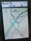
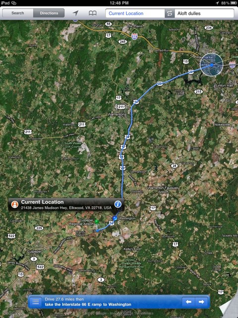
Get yourself an external bluetooth GPS and then you can pair any regular iPad to it and not have to pay the premium for the cellular model or the monthly service for it.
 
  • Like
Reactions: Boyd

Boyd

Administrator
Staff member
Site Administrator
Jul 31, 2004
9,502
2,765
Ben's Branch, Stephen Creek
As I have written before, have been very happy with my Garmin GLO for many years now. It is also a very useful accessory to improve the accuracy of any phone or tablet, it will provide much better accuracy than the built-in GPS. Get the optional belt clip if you want to use it in the field. If you clip it to your hat you will get better GPS reception because your body won't block the signal like it does when holding a GPS in your hand.

I see that GPSCity currently has a certified refurbished GLO2 bundle that includes the dashboard friction mount for $90. This will give your iPad a GPS but you will have to either use an app with onboard maps or a hotspot connection to the cellular network if you want to use my app.

 
  • Like
Reactions: TommyP

TommyP

Explorer
Mar 30, 2022
185
178
Clementon
thomaspluck.substack.com
The position updated on the iPad and I was in the car using the iPhone as a hotspot. It may have been getting it through Find My iPhone or something similar, they are on the same Apple account and I've noticed they sync things Apple doesn't tell you about.
 
  • Like
Reactions: Boyd

Boyd

Administrator
Staff member
Site Administrator
Jul 31, 2004
9,502
2,765
Ben's Branch, Stephen Creek
That's cool. Quick search found this, it's old but seems to describe what you are seeing. But were you using Apple Maps or my app? Wouldn't be surprised if Apple Maps could do this but other apps couldn't.

 
Top