"The wagon train, reporting containing upwards of 500 vehicles (if my memory is correct), went up the Salem Road/King's Highway to Moorestown, while Cornwallis, his troops, and many of the Hessians went out Old Borton Mill Road/Kresson Road to a local road in the area of Marlkress "
You must be very old to remember this.., but the true route was NOT Kresson Road to Markress, But Cornwallis troops took the Marlton Pike, first crossing Bonnie's Bridge, to Greentree.
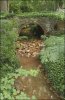
"The grassy span, called Bonnie's Bridge, spans a narrow stream between two houses on Wayland Road in the Barclay section."
Neil in SJ:
Well, aren't you the funny guy?!?!?!?!

Regarding the routing of Cornwallis and the troops that traveled with him out of Haddonfield, I would like to see your primary source evidence for your contention that they moved over Bonnie's Bridge, because I certainly have my primary sources available here in my library. These sources include Johann Ewald's diary; Major Andre's journal; Hessian maps; British cartographer John Hills's maps; Simcoe's Journal, and other contemporary sources. When the army left Haddonfield, livestock owners drove their cattle north into Charleston Woods, which the British would have found quite readily if they traveled the route you suggest. By traveling out Borton Mill Road, the British missed the opportunity to forage the cattle because they remained south of the livestock. In addition, your information is faulty because the Marlton Pike did not come into existence until 1796. In 1767, surveyors laid out the Cooper's Creek Road, forerunner of the Marlton Pike, but only from the Salem Road to Camden and not eastward. To go eastward required moving up Salem Road to reach the A-33 road, which extended eastward along the northern reaches of the swamp near present-day Sawmill Plaza shopping center, which the stream running under Bonnie's Bridge drains.
If you research Bonnie's Bridge in Gloucester County records, you will not find a single reference to the span, neither couny funds paying for its construction nor for any subsequent maintenance of it.
There are three current schools of thought about Bonnie's Bridge among local historians. The first idea places its construction in the 17th century when John Kay built his original house and plantation where the Barclay farmstead currently stands. Since the Marlton Pike or any other predecessor roads failed to run eastward giving Kay easy access to his house, he had to extend a lane to his house, crossing all necessary streams in the process. He likely contracted with Francis Collins to build the bridge as part of his lane to the plantation with the other end of the private road connecting to the Salem Road before it crossed the North Branch of Cooper's Creek.
The second idea, proposed by a good friend and geographer, suggests that the bridge was part of a garden folly, constructed during the first half of the nineteenth century when members of the Cooper family owned the property. There are other foundations farther upstream from the bridge in the backyard of one of the adjoining landowners built of the same brick and silcrete or Sarsen stone as the bridge's construction material. These foundations may have been part of a classic "ruins" scene often used in such follies.
The third idea is that bridge offered a crossing for a shunpike, a road that allowed travelers to avoid the toll house on the Marlton Pike at Ellisburg.
Whatever the source of the bridge, private money funded its construction, which means it never provided a crossing for a public road. Furthermore, no road returns exist for a road across the bridge, although with that in mind, the original Waterford Township minute book did not survive the rigors of time, so we do not have access to any of the road surveys recorded in that volume.
So Neil in SJ--you show me yours and I'll show you mine!
Jerseyman

")