john mcphees, the pine barrens

piker56

Explorer
Jan 13, 2006
640
53
67
Winslow
http://teegate.njpinebarrens.com/07162011/1.jpg


1.jpg


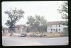
My 1971 Friendship photo, then and now.

http://teegate.njpinebarrens.com/07162011/1.jpg

Thanks for re-posting this picture. I was by there so many times as a teen, but never took a picture.
Greg
 
  • Like
Reactions: Pan

Teegate

Administrator
Site Administrator
Sep 17, 2002
25,602
8,180
The Bill Curtsinger edition of McPhee's book has a photo of Brown's cabin. You can't really tell where it was located from it though.

I have attempted to get permission from the Haines' to explore the site but have been unsuccessful.


It is not safe for people to be there. The place is falling down.
 
  • Like
Reactions: Pan

Pan

Explorer
Jul 4, 2011
554
246
Arizona
Guy took the Friendship now photo. I was back there with him last year. It sure has changed. But deep in the woods it's all still the same.

I remember the day I took that picture. It was the first time I went to Friendship. It was very quiet except for the sounds of farm animals. Real country. Too bad I only took one photo, but there were people around and I didn't want to make myself conspicuous.

There are some blowups of parts of that photo on its original thread. The original photo is a colour slide, probably Anscochrome. I'm going to see if I can rescan it and get maximum detail and maybe get some better blowups.

I have other photos that I took around the Pine Barrens in that same time period scattered around here.
 

Pan

Explorer
Jul 4, 2011
554
246
Arizona
That is a great picture. I'm just trying to get my bearings with it.

Is the two story white building on the right the packing house?


Beats me, but the town was already going to ruin and only sparsely inhabited. The white building looks abandoned. Weren't all the inhabitants ordered to all move out by the next year or so? Why? Because the state bought the land and was going to build an airport there, or the military bought it, or what?
 

Teegate

Administrator
Site Administrator
Sep 17, 2002
25,602
8,180
Ben,

That is the intersection of Carranza and Friendship Speedwell Road. The packing house is hidden in the distance.
 
  • Like
Reactions: Pan

Ben Ruset

Administrator
Site Administrator
Oct 12, 2004
7,616
1,863
Monmouth County
www.benruset.com
  • Like
Reactions: Pan

Pan

Explorer
Jul 4, 2011
554
246
Arizona
I rescanned the slide. Not really any more detail on the blowups (available on the original page) because of the grain limitations in the film, but slightly more extension to the sides, especially the left side, showing the complete tank on top of the little shed, and a little more of that small fence in front of the shed. I'll see if I can get it better because I haven't used this scanner in a long time and I've sort of forgotten how.
 

Pan

Explorer
Jul 4, 2011
554
246
Arizona
i tried to upload the new scanned photo here but i got an error message, maybe because the file is too big.
 

ecampbell

Piney
Jan 2, 2003
2,840
958
Pan, that's a wider version than you posted before. Notice what looks like a livestock fence on the left, and what's that dark thing on top of the shed? I no doubt passed it many times.
 
  • Like
Reactions: Pan

Pan

Explorer
Jul 4, 2011
554
246
Arizona
I sent you an email, Ben.

EC - It looks like some sort of tank. I remember the livestock in Friendship, chickens and roosters and maybe sheep bleating or something. I remember the quiet country sound of the place.
 

Pan

Explorer
Jul 4, 2011
554
246
Arizona
The lost town of Friendship, NJ. I remember the day I took the picture, the quiet country sounds of the farm animals. It was already more than half abandoned...
 

Attachments

  • Gleeson, azlwf2.jpg
    Gleeson, azlwf2.jpg
    28.3 KB · Views: 286
Top