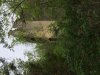
His house is here http://maps.njpinebarrens.com/#lat=39.35062042122361&lng=-74.95610016983034&z=16&type=nj2015&gpx= he owns north of the road you see below his house and that is the blacktop rd with gate. the old bridge across creek is here http://maps.njpinebarrens.com/#lat=39.34942572972994&lng=-74.95813864868165&z=16&type=nj2015&gpx= very old hard to see sneak around rd is here http://maps.njpinebarrens.com/#lat=39.34680397425975&lng=-74.95498437109501&z=16&type=nj2015&gpx=. this is a legal sneak around but it helps to avoid having to tell him off.You will pass old ties imbedded in ground along swamp.thats the old chapel they used to preach to us younguns at.. thats about here http://maps.njpinebarrens.com/#lat=39.34828079811444&lng=-74.9568726462415&z=16&type=nj2015&gpx= Fries mill town site with mill along raceway is here. Old interpretive sign on site with map to foundations.Nice Job! Now everyone knows! http://maps.njpinebarrens.com/#lat=39.349060681265414&lng=-74.96030587378056&z=16&type=nj2015&gpx= old tavern ruins with two chimneys here http://maps.njpinebarrens.com/#lat=39.34524414888448&lng=-74.96309537115604&z=16&type=nj2015&gpx= one more chimney here http://maps.njpinebarrens.com/#lat=39.342655425687106&lng=-74.9640609664014&z=16&type=nj2015&gpx=
Key's Sandwash--Menantico Ponds?
- Thread starter htucker7161
- Start date
You are using an out of date browser. It may not display this or other websites correctly.
You should upgrade or use an alternative browser.
You should upgrade or use an alternative browser.
Thanks! I will check it out when the weather warms up. I must be too young to have heard of Camp Hollybrook, doesn't sound familiar at all.
Camp Hollybrook went out of commission in the late 70"s.I was an Apache there the summers of 70,71.Which means I was six and seven years old.It was a YMCA camp. Boys were either Apache,Blackfoot or Comanche with youngest being Apache and girls were on the north side of the road around where ying yangs house sits now.They were the Choctaws,Chickasaws and Cherokee. The old Fries Mill cabin still stood with an old piano still in it and readers digests in the cellar in mint condition from the 40's.They took us there at night and regaled us of stories about Potters Cabin and Potters ghost that haunted the place.Young punks burnt it to the ground in the early 90,s.two chimneys still stand and remains of the cedar longs an d nails and the actual stone lining of the door still sand. Many cellar holes at the mill proper along with the actual mill foundations along the old raceway and another chimney further south down near the tracks.
Zach: just a suggestion, use NJPB maps instead of coordinates or links to Google. Drag the pin to the spot you want to mark. If it disappears, reload the page. Then just copy and paste the link into your post. You can choose from many map options using the dropdown menu at the top left of the page, here are a couple examples
http://maps.njpinebarrens.com/#lat=39.37777419916251&lng=-74.99345836562111&z=15&type=topo&gpx=
http://maps.njpinebarrens.com/#lat=39.37719698158981&lng=-74.99339225297445&z=19&type=nj2012&gpx=
Also, if you want to post coordinates, it makes things much easier if you use decimal degrees.")
http://maps.njpinebarrens.com/#lat=39.37777419916251&lng=-74.99345836562111&z=15&type=topo&gpx=
http://maps.njpinebarrens.com/#lat=39.37719698158981&lng=-74.99339225297445&z=19&type=nj2012&gpx=
Also, if you want to post coordinates, it makes things much easier if you use decimal degrees.
Hi Zach! The stone house was still there, on the Maurice River Bluffs as of last February. There are "do not cross signs" warning people off. I would post a picture of it (if I had one), but posting said picture would be acknowledgment of a crime, and I try to follow the rules, unless taking a picture of an old stone structure is an essential part of my mission to document the Pinelands in all of its beauty and history. And of course walking up and snapping a photo does not harm anything, but of course, I did not do that, on February 13 of last year.
I have a couple of photos that I took in May, of the building I think you are talking about.
Attachments
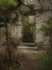
Is the shell of the old stone house above the bluffs still standing? Haven't been back there in years, and it looks like they moved the access road.
Funny, it never occurred to me that "sandwash" wasn't a universally understood term. I guess it's actually quite the opposite-- a Cumberland County regionalism. Used to spend most of my time as a kid at the sandwash between Schooner Landing Rd. and the Manumuskin creek, along the old rail yard where they now store all the tank cars. Loved swimming back there as a teenager, but I've been stopped by the state police the past few times I've walked back there and questioned. Apparently it became quite the well-known party spot in the last decade or so, with kids opening the trails to vehicles for easier access. I've more recently heard the southernmost lake referred to as "Loon Pond."
I'm from Vineland and we called them sandwashes too (more like sand waRshes). Always knew not to swim in them, so when I saw all these shoobies swimming in the washes by the Manumuskin one summer day I was surprised. There's an eerie history to those Menantico ponds, including devil worshipping, weird shrines, and a teenagers murder back there in early 70s. Kid drowned out there this summer. Still beautiful though.