Your maps work in both Google earth and Globalmapper for me! Now all I need to do is figure out to convert KMZ to RMP.Their beautiful Boyd!

LIDAR enhanced aerial views
- Thread starter Boyd
- Start date
You are using an out of date browser. It may not display this or other websites correctly.
You should upgrade or use an alternative browser.
You should upgrade or use an alternative browser.
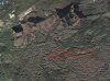
Bob that looks like a mountain holler! Is there enough water in it to make shine?
Nary a drop Al! You have to dig through sphagnum and peat first, or head to the river proper to set up a proper draw line.

A whole new world opens up. It was easy to convince myself (rightly or wrongly) that these are relict dunes from the ice-age.

What is the file extension name that garmin uses for the map files.Like Triton uses RMP files,what does garmin use?
Al, they are .kmz files. .Kmz was originally created by Google to use with Google Earth IIRC. If you can't find a way to convert these, send me a PM and I may be able to provide you with something else that would work better, such as geoTIFF.
Glad to see you're enjoying it Bob! Yes, it really does give you a new way of looking at things, makes the regular aerials look kind of dull. But of course the full resolution NJ aerials do contain 100x more detail than the LIDAR imagery (1 ft/pixel vs 10 ft/pixel). I thought about mapping the full res aerials onto the LIDAR, but that results in some HUGE files - the 22 map tiles here would grow from 90MB to 9GB!
I have tried to convert the KMZ to RMP and every where I go they state this cannot be done.So next I converted the KMZ file into KML using Google Earth and this gave me 25 tiles that start with kml then have a number and end up with jpg. so I have 25 little jpegs to make up[ the Atsion triangle which is the one I elected to experiment with.I cannot stitch these together using LizardTech geoviewer though they will opewn individually in it.I assume that in converting I have destroyed the georeferencing. I cannot stitch them in Microsoft ICE because they do no overlap like a panorama.The only thing I know to do now is to painstakingly hand match them in GIMP and then save them that way and when I have that many tiles something generally ends up going wrong,in any case it would take several hours to do one map that way.So yes could you please send me the TIFF's if you have them.If you have to make them and it's a pain then please don't go out of the way on my part.I could always get the coords of anything I need off the KMZ in either GE or Globalmapper and then just stick them in the GPS and I could print the image to take with me for reference.But if you already have the tiff images please either send them or post them.Al, they are .kmz files. .Kmz was originally created by Google to use with Google Earth IIRC. If you can't find a way to convert these, send me a PM and I may be able to provide you with something else that would work better, such as geoTIFF.
Thanks again!
Boyd, this core map of the Barrens is incredible. Your hard work is greatly appreciated and I don't think you will be able to out do this map! Thank you very much!
Bob, did you check out the parabolic dune that sits in the northern part of Parker yet? Very cool!
It was easy to convince myself (rightly or wrongly) that these are relict dunes from the ice-age.
Bob, did you check out the parabolic dune that sits in the northern part of Parker yet? Very cool!
Bob, did you check out the parabolic dune that sits in the northern part of Parker yet? Very cool!
During our botany investigations, one person in our group had the task of checking the plants on all of them, but I never visited the ones he checked. Since I roam freely there, I may have walked over it and never suspected it. Can you pinpoint?
I do know that on one of our trips that Guy and I designed, we hit quite a few here:
Attachments
I've been to that dune/island.We pbx ed across some even nicer dune islands to the sw.There are loads of them in that area.
Thanks Gibby! But I'm always looking for ways to outdo myself, haha. 
Al, here is the Atsion quad in geoTIFF file, along with a world file and projection file. Let me know if works in TritonRMP. We discussed this before, and there's a program called TritonRMP Helper at Free Geography Tools that is supposed to make this easier. If it works, I can do a few more quads for you. These files are a lot bigger than the .kmz though and take awhile to upload on my slow DSL.
http://boydsmaps.com/download/atsion_tiff.zip
I think you now have a Triton 1500? If so, I would forget the native Magellan software are run OziExplorer on your Triton. These devices are based on Windows CE and can actually run alternate software. The map files are easier to make and they zoom in/out as far as you want to go. Also lots of track/waypoint features. See my thread about this here:
http://forums.gpsreview.net/discussion/12646/x/p1/
I stopped using this long ago and when I setup a new PC recently didn't bother to move any of the files. But I should still have everything (somewhere) on a backup disk, including a large quantity of the NJ2007 aerials and scanned USGS 24K maps. You can switch between and Oziexplorer and the native Magellan software by just rebooting, so it's possible to have both on the Triton.
If you're interested, send me a PM.
The TIFF works in Triton RMP! I"ll keep working on a way to stitch your KMZ tiles back together either as jpegs or TIFF's.The Geoviewer should do this but it's not.I"ll have to calibrate this tiff and put it in the triton and see how it looks.I remember downloading OZI Explorer once and having trouble figuring it out so I uninstalled it.I"ll have to try it again.
Thanks!Again don't use up your time making tiffs for me.I thought maybe you had already made a bunch of them.I can see the maps just fine on the computer and thats good enough if I can't figure anything else out.
Thanks!Again don't use up your time making tiffs for me.I thought maybe you had already made a bunch of them.I can see the maps just fine on the computer and thats good enough if I can't figure anything else out.
Last edited:
Okay after more internet bufoonery I"ve come to the conclusion after converting the KMZ into a KML in GE which will give me 25 little jpegs per quad I can then hand align them in Gimp and save as a jpeg or tiff and then calibrate in Triton rmp.From start to finish once I get fast i can probably do a map an hour,A nice project once I get the new machine running or I can lay down 4 big ones for Global mapper and convert the KMZ straight into an RMP.Much easier but not worth 4 big ones.I think I"ll make a project out of whatever quads Boyd does I"ll hand align and make tiffs out of and if anyone needs tiffs I"ll put em up somewhere and link to em though I think I"m the only one on here that uses magellan.
If anyone ever sees a cheaper version of Globalmapper let me know.For 400 bucks it better come with a waterbed and jicuzzi.
If anyone ever sees a cheaper version of Globalmapper let me know.For 400 bucks it better come with a waterbed and jicuzzi.
It also may be a limit of the database architecture, not memory capacity, they use on those devices.
Sorry, meant to comment on this before. Let's give Garmin the benefit of the doubt.... the custom maps .kmz format was released before Birdseye. So maybe they just kludged something simple together.
But OziExplorer had a program that ran on wimpy, cheap Windows CE devices many years earlier. Their format is really efficient. zooms way in and out, and can cover huge areas in multi-gigabyte files. And that was developed by one guy as a hobby!
When Garmin announced Birdseye (I think it was the same year) it used a new file format - .jnx - I have seen a 50,000 tile limit mentioned. It also zooms and scrolls faster than .kmz maps and shows through a wider range of levels. But .jnx was intended as a copy protected commercial format and the files must be authorized by garmin for your specific gps. I've read that if you already have a valid Birdseye subscription, 3rd party .jnx files will work. I no longer have a subscription and haven't tried this. You can also hack the gps firmware to bypass authorization somehow.
This is sticky stuff IMO, since these techniques might also apply to stealing Birdseye data instead of purchasing it from Garmin. But there's no techncial restriction preventing you from loading LIDAR for the whole Northeast. It's a roadblock Garmin has placed in the software that only allows it to be used with their own commercial products.
You know, I'm fine with that. It's dog eat dog in the GPS business today and they sell Birdseye at a very reasonable price. I just wish they would let us create bigger maps somehow. At least they went from 100 tiles to 500 on the new models.
Isn't it what Al calls his favorite island? We went there on a PBX trip that started at Jones Mill? The year after that I went to it on a botany class, Philly Botanical Club trip.During our botany investigations, one person in our group had the task of checking the plants on all of them, but I never visited the ones he checked. Since I roam freely there, I may have walked over it and never suspected it. Can you pinpoint?
I do know that on one of our trips that Guy and I designed, we hit quite a few here:
Isn't it what Al calls his favorite island? We went there on a PBX trip that started at Jones Mill? The year after that I went to it on a botany class, Philly Botanical Club trip.
Yes, that is it. By the way, we did get a map during the course that shows all the dunes in the area.
I was able to get the files to load in BaseCamp on the Mac and it works with Google Earth. I use the Lidar all the time when searching for stone but it is really nice now to have it right in Google. I like you Boyd am not a fan of BaseCamp and usually zip the application except when I need to use it such as today. Unfortunately, the limit on my Oregon will be a problem and I most likely will not be able to use them on my GPS.
I like it in GE, will use it mostly there with the WMA boundary overlays and toggling the topo on and off which gives an excellent idea of an area. Not so much in BaseCamp.
A big update is on the way soon with greatly expanded coverage. ")

The contrast and color have been enhanced so it should look better on the GPS screen, but I still need to do some testing.

Should be available sometime next week if I don't run into any problems. I will post the download link to this thread.

The contrast and color have been enhanced so it should look better on the GPS screen, but I still need to do some testing.
Should be available sometime next week if I don't run into any problems. I will post the download link to this thread.
Tom my fgavorite island is the one just se of that one with a large white area showing on it's west end.We did go through there on a pbx tripIsn't it what Al calls his favorite island? We went there on a PBX trip that started at Jones Mill? The year after that I went to it on a botany class, Philly Botanical Club trip.