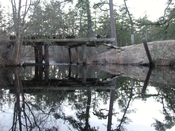
Lock's Bridge

All,

Yesterday while exploring near Atsion I came to a bridge that the Magellan topo calls Lock's Bridge. It is a beautiful area on the Mulica where there is a bridge that is in ruins but still crossable by foot. A few yards bast the bridge the Mulica rushes by and there is no bridge. I assume it was washed away or there may have been only a causeway there at one time. A woman hiking there told me there were many beaver dams there but I only saw one.

Here is the location on Topozone:
http://www.topozone.com/map.asp?lat...lon=-74.6938433333333&datum=nad83&u=7

Here are some shots:

http://www.njpinebarrens.com/albums/Lock-s-Bridge/Locks_Bridge_1.sized.jpg

http://www.njpinebarrens.com/albums/Lock-s-Bridge/Locks_Bridge_2.sized.jpg

http://www.njpinebarrens.com/albums/Lock-s-Bridge/Locks_Bridge_3.sized.jpg

http://www.njpinebarrens.com/albums/Lock-s-Bridge/Locks_Bridge_4.sized.jpg

http://www.njpinebarrens.com/albums/Lock-s-Bridge/Locks_Bridge_5.sized.jpg

http://www.njpinebarrens.com/albums/Lock-s-Bridge/Locks_Bridge_7.sized.jpg

http://www.njpinebarrens.com/albums/Lock-s-Bridge/Locks_Bridge_8.sized.jpg

http://www.njpinebarrens.com/albums/Lock-s-Bridge/Locks_Bridge_9.sized.jpg

http://www.njpinebarrens.com/albums/Lock-s-Bridge/Locks_Bridge_10.sized.jpg
 

Teegate

Administrator
Site Administrator
Sep 17, 2002
25,602
8,180
Nice photo's Steve and and nice tags on the photo's also.

That bridge design with no railings or boards on the sides of the bridge seemed to be popular in the past, and you don't see many that have survived.


Guy
 

Teegate

Administrator
Site Administrator
Sep 17, 2002
25,602
8,180
I am not sure when they were built, but certainly before the 70's. Here are three photo's of bridges without railings or boards that appear to me to be similar in design.

This one is just south of Quaker Bridge on the road to Batsto taken in 10/78

http://www.njpinebarrens.com/~teegate/10_78.jpg

This one is behind the camp ground across from Carranza Memorial taken in 1/76 with my brother in the photo.

http://www.njpinebarrens.com/~teegate/1_76Brad.jpg

And this one I am not sure where it is but it was taken in 10/75 just a few months after I purchased my first Land Cruiser.

http://www.njpinebarrens.com/~teegate/John10_75.jpg

Guy
 

shamongjeeper

New Member
Jan 22, 2004
7
0
Shamong, NJ
TeeGate said:
This one is behind the camp ground across from Carranza Memorial taken in 1/76 with my brother in the photo.

http://www.njpinebarrens.com/~teegate/1_76Brad.jpg


Guy

I definitely know where that bridge is. When you come to the Batona campsite, you make a right? And the bridge is about a mile and a half down that road. There's signs there too, Wt. Limit, 3 Tons. Everytime me and my brother travel that road we stop on the bridge. Usually we end up coming back over it instead of going all the way through to RT. 532, because of the two large water holes in the middle of the road. At the end of that road I am talking about is a road to the right that leads to the Apple Pie Hill Fire Tower.
 

Teegate

Administrator
Site Administrator
Sep 17, 2002
25,602
8,180
It has been years since I have been there, but I am certain you are correct. That photo was taken in 1976. I will have to visit it again soon to creat another Then & Now photo. Maybe i could get my brother to sit on the bridge in the same place, even though he would take up quite a bit more space now.

Guy
 

RednekF350

Piney
Feb 20, 2004
4,944
3,080
Pestletown, N.J.
I always wished that place fished as good as it looks for pickerel.
Still a neat little hideaway in the pines and you can catch all the 6" catfish you want in the summer.
 

MuckSavage

Explorer
Apr 1, 2005
597
218
56
Turnersville
Is this Lock's Bridge?
locksbridge2.jpg
 

Kevinhooa

Explorer
Mar 12, 2008
332
25
41
Hammonton, NJ.
www.flickr.com
Just a note on this place... on the southern side where all the paths go through that lead to the Mullica River Wilderness Camp, there is a small cleared area down by the water. This is about 75 yards south of the actual old bridge abutment site. In the pool of water on the edge is a huge piece of sandstone (or a foundation) I noticed one time when the water was low. Just recently a pine tree growing on top of it blew down revealing even more of the rock underneath.

Also, I did notice the slag all over the place around there but I have never heard or read of a forge being there. I'm sure it's possible as the location is perfect considering that raceway trench on the western side of the river, and rapid drop in height of the river. I just always assumed it was an actual "lock" of sorts for the large durham boats that used to transport raw bog iron and other goods between Atsion & Basto. I just thought that the slag was put in place as a helping style of rip-rap to keep the bridge abutments and lock edges from eroding away. But a forge would be very interesting.

http://www.flickr.com/photos/kevinhooa/sets/72157623478614525/
 
  • Like
Reactions: Bachman's Ivory

kayak karl

Explorer
Sep 18, 2008
495
79
68
Swedesboro, NJ
Just a note on this place... on the southern side where all the paths go through that lead to the Mullica River Wilderness Camp, there is a small cleared area down by the water. This is about 75 yards south of the actual old bridge abutment site. In the pool of water on the edge is a huge piece of sandstone (or a foundation) I noticed one time when the water was low. Just recently a pine tree growing on top of it blew down revealing even more of the rock underneath.

Also, I did notice the slag all over the place around there but I have never heard or read of a forge being there. I'm sure it's possible as the location is perfect considering that raceway trench on the western side of the river, and rapid drop in height of the river. I just always assumed it was an actual "lock" of sorts for the large durham boats that used to transport raw bog iron and other goods between Atsion & Basto. I just thought that the slag was put in place as a helping style of rip-rap to keep the bridge abutments and lock edges from eroding away. But a forge would be very interesting.

http://www.flickr.com/photos/kevinhooa/sets/72157623478614525/
nice pic's. this is my next hike out of Batsto.
Thank You
KK&K
 

glowordz

Explorer
Jan 19, 2009
585
8
SC
www.gloriarepp.com
All,

Yesterday while exploring near Atsion I came to a bridge that the Magellan topo calls Lock's Bridge. It is a beautiful area on the Mulica where there is a bridge that is in ruins but still crossable by foot. A few yards bast the bridge the Mulica rushes by and there is no bridge.

You're so right that it's beautiful--one of my favorite spots when I come to visit, complete with beaver dam. Thanks for the photos! Interesting info too--I've wondered about the bridge.

Glo
 
Top