Kevinhooa,
You are so right; there are many stories yet to be told within the Pinelands National Reserve – even south of the Mullica. Blogs like this are evidence enough that a Jerseyman can still enjoy a spirited adventure in South Jersey. Jack McCormick, in his ecological assessment report to the National Park Service, made a convincing case for the region’s value to environmental studies. But every bit as important as natural treasures are Pinelands cultural elements. Let’s not forget that the mission of the 1979 Pinelands Act, in part, “is to preserve, protect, and enhance the natural and cultural resources of the Pinelands National Reserve.”
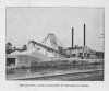
For example, let’s consider the social geographic context of the sand plant. Weymouth Siding was the site of Edwina, one of a number of failed Am Olam colonies hatched along the railroad corridors of Atlantic, Cumberland, and Cape May Counties. Its inspiration was the Jewish “back to the land” movement that began with the Pogroms in Russia. These land and agricultural schemes, along with other ethnically based land-improvement companies, were part of the speculative boom that precipitated the Panic of 1893. The Panic was an economic depression that truncated ambitious plans to tame (urbanize) the Pines. Within a dozen miles of Edwina were the settlements of Royalton, Hebron, Rotham, Ruskville, Mizpah, Burbridge, Thelma, and Reega.
Today, another speculative boom threatens Pinelands environmental integrity – exurban sprawl. Instead of railroad tracks, it is proposed sewer lines that now drive a rush to develop. Along the Route 40 corridor between Buena and Mizpah, there are currently four redevelopment plans that will overlay existing zoning rules (see the earlier post “Development plans threaten Buena Vista Pinelands"). Each plan anticipates sewering, not just in Pinelands Towns and Villages, but extending coverage to land currently zoned for Rural Development. We are misusing public funds to encourage exurban sprawl in the middle of an internationally renowned biosphere.
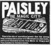
What’s next, invoking urban renewal to resuscitate Paisley – a famed railroad-era boondoggle planned midway between Chatsworth and Tabernacle? It too was spurred by a township’s speculative race for a “false tax base,” nicely chronicled in “Land Utilization in New Jersey: A Land Development Scheme in the New Jersey Pine-Area" (Lee, 1939). Should you wish to learn more about the dynamics of railroad-era colonization and its socio-economic impact, consider signing up for my Pinelands Short Course presentation, "Come Earnest Homeseekers: Ethnic Settlements in the Pines."
Kind regards,
Spung-Man

") .
.