My map project

Boyd

Administrator
Staff member
Site Administrator
Jul 31, 2004
9,502
2,765
Ben's Branch, Stephen Creek
Like many of you, I have been frustrated by the quality of Garmin's topo maps. So I've been doinig some research on this recently, and am finally putting together all the pieces to create my own, high resolution garmin-compatible maps of the pinelands. The map should be compatible with most newer Garmin units - if you have a Garmin mapping GPS wiht a USB interface then it will probably work (60csx, eTrex, Nuvi, Colorado, Oregon). When this project is finished, I will make it available for free. But I'm not quite there yet.

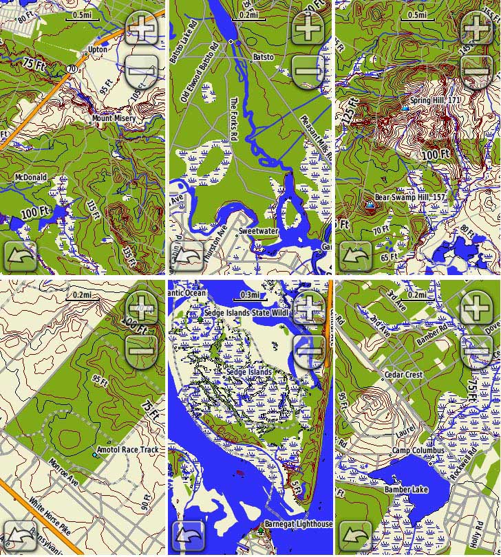
So today I loaded a section of my current alpha version onto my Oregon 400t and Nuvi 5000 and hit the road for a cruise through some familiar parts of the pines. The screenshots below compare my pine barrens map to Garmin's US Topo 2008... the "landscape" images are from the Nuvi and the "portrait" shots are from the Oregon:

or-01.jpg

nu-01.jpg


or-03.jpg

nu-03.jpg


or-05.jpg

nu-05.jpg


I won't go into too much detail about the process of creating these, but the primary software I'm using is GlobalMapper for creating the map and CGPSmapper for compiling it into Garmin's format. It's a pretty time-consuming process, but I'm learning a lot along the way.

All the data has come from public, government sources:

High resolution DEM (digital elevation model) topographic data from the usgs seamless map server, hydrography data from the usgs NHD server. Boundaries of state-owned land are from njdep, roads from the US census bureau TIGER shapefiles. I am still looking for more data to include, but the usgs servers were down for maintenance most of the weekend so I decided to make my alpha version with what I already had.

The cool thing is that once all this stuff is loaded into GlobalMapper you can do all sorts of things with it. I put a couple screenshots in my NJPB gallery - click on the thumbnails below for larger versions. You will need to click on them again in the gallery to seem them full size:


Since things are so flat in the pines, I sampled the DEM data at 5 foot intervals when creating the contour lines. I think this makes for a more interesting map and reveals a bit more about the lay of the land. Actually, I'm pretty sure that the water and contour data is higher resolution than the 24k USGS topos.

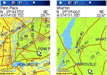
But what about the 60csx and other Garmin units with smaller screens? The maps displayed fine on my 60csx, but had one annoying glitch. The road names were unreadable; evidently the 60csx can't handle lowercase characters very well... I need to study this further before releasing my beta version. It may be necessary to create a separate version for these units. I made a trial run here where I converted all the labels to UPPERCASE and it seems good, but I wouldn't want to limit newer GPS'es to uppercase only.

60csx.jpg


I would like to make the beta version of my map available as my Christmas present to the NJPB community, but Santa might get a little backed up so please be patient :) This is going to be a pretty big file... my sourcefile is already over 500MB, but since Garmin's format seems pretty efficient I'm guessing that the actual .IMG file might be 40 or 50MB.. we'll see. The boundaries of my current dataset stretch from the southern tip of Cape May up to somewhere around Interstate 195. Heh, when I tried feeding it to the compiler yesterday it finally quit with an error message after 16 hours, so I've still got some work to do there.

More on this as I progress....
 

Teegate

Administrator
Site Administrator
Sep 17, 2002
25,602
8,177
Well done Boyd! I like the elevation lines in your topo maps. I would certainly love to beta test it.

Guy
 

Teegate

Administrator
Site Administrator
Sep 17, 2002
25,602
8,177
Boyd,

What is the name of the software in the bottom two photo's? My topo's don't look anything like any you have and I have the 2008 Garmin topo's. I have never been happy at all with my topo's. It is as if they are not complete. I have the setting's on the highest quality, but I have very little info that display's.

Guy
 

Boyd

Administrator
Staff member
Site Administrator
Jul 31, 2004
9,502
2,765
Ben's Branch, Stephen Creek
Are you talking about the two screenshots from the 60csx? That's my new map loaded onto the GPS and captured with Garmin's xImage program.

Or do you mean the two thumbnails which link to my gallery? Those are screenshots from Global Mapper, which is the program I'm using to import and edit everything.
 

Boyd

Administrator
Staff member
Site Administrator
Jul 31, 2004
9,502
2,765
Ben's Branch, Stephen Creek
Thanks all... stay tuned for more info.

46er, what map are you viewing in MapSource? That looks like the simple basemap. Do you have the Garmin Topo map? If so then you should be able to set it to display more detail. When I am ready to release this I should be able to make it work with MapSource as well as in the GPS, but that's something I haven't really looked at too carefully yet.
 

46er

Piney
Mar 24, 2004
8,837
2,143
Coastal NJ
Boyd, yes that's TOPO2008 on Mapsource, it's at the highest detail level and it looks the same on the NUVI.
 

Boyd

Administrator
Staff member
Site Administrator
Jul 31, 2004
9,502
2,765
Ben's Branch, Stephen Creek
Boyd, yes that's TOPO2008 on Mapsource, it's at the highest detail level and it looks the same on the NUVI.

That's odd. Are you sure the detail is at the Max? The bottom screenshot is what US Topo 2008 looks like on my Nuvi:

nu-03.jpg


I guess that is a pretty flat area, so not many elevation contours visible. But I see at least one in my screenshot which doesn't show on yours.
 

46er

Piney
Mar 24, 2004
8,837
2,143
Coastal NJ
Yep, at the highest detail level. The swampy area shows as lines, nothing like yours. Maybe its a difference in the NUVI models, mine is a 750. Is what you see on your NUVI the same as what you see in Mapsource? Mapsource is at 6.12.4, Topo2008 is at data version 4.


Just updated Mapsource to 6.14.1 and the contour line in yours now shows, roads are similar to yours, marsh is still lines. Will upload to the NUVI tomorrow.
 

Boyd

Administrator
Staff member
Site Administrator
Jul 31, 2004
9,502
2,765
Ben's Branch, Stephen Creek
The 750 should look just like my screenshots. I used to have a 650 and it looked the same. This is pretty obvious, but I assume you are disabling the City Navigator maps when you use the topo on your Nuvi, right? Do this by unchecking them with Menu > Tools > Settings > Map > Map Info. If you leave the City Navigator maps active they will hide the topo.

Mapsource is another thing though... the swampy areas are indeed just represented as those lines. Well, hold on a little longer and you can see how my map looks when it's ready. :)
 

Boyd

Administrator
Staff member
Site Administrator
Jul 31, 2004
9,502
2,765
Ben's Branch, Stephen Creek
Cool... but be careful with that new MapSource, I gather it creates all kinds of problems. I have not upgaded myself for this reason. I think it specifically has problems with the kind of "homegrown" maps I'm making. Since Garmin has never released the specs on their map format, all the existing software for map creation has been reverse-engineered.

Updating Mapsource should not have any effect on the Nuvi though. It is just displaying the files which came from the DVD.
 

46er

Piney
Mar 24, 2004
8,837
2,143
Coastal NJ
Updating Mapsource should not have any effect on the Nuvi though. It is just displaying the files which came from the DVD.


Understood, but I load the NUVI with Mapsource. I really did expect better.

Welp, I tried looking at the same location from the Garmin website and it shows exactly the same what I'm seeing on my computer and NUVI. I guess this is what I get. I'm going to post on the Yahoo TVNAV Garmin group site and see what kind of response I get. I'll start a different post so as not to clutter up your thread.

http://farm4.static.flickr.com/3179/3092836728_4229bf5e90_o.jpg
 

Boyd

Administrator
Staff member
Site Administrator
Jul 31, 2004
9,502
2,765
Ben's Branch, Stephen Creek
Yeah, I think that is about all you get from US Topo.... which is why I decided to make my own map :). Remember, the Garmin US Topo is comparable to the 100k USGS Topo maps in terms of resolution. This is a bad scan from TerraServer, but the area in your screen shot is roughly comparable to the little rectangle below:

100k.jpg


There just isn't the opportunity to put much detail in that space. 100k means that one inch on the map equals 100,000 inches (about a mile and a half) in the real world. Now on your gps or computer screen, you are zooming way in (because you can), so it shouldn't really be a surprise that curves start looking like sharp edges and there isn't much detail.

The better USGS maps are 24k (1:24,000) so those are 4 times better (actually 16x better in terms of area), but still pretty coarse if you blow them up too much. Garmin is slowly releasing 24k versions of their topo maps, but only has a few of the Western States so far. For a comparison, see the screenshots in this review:

http://gpsinformation.info/penrod/24Kmaps/twofourmaps.html

My hope is to come up with something a bit better than this even. I haven't dug deeply enough into Garmin's format though to understand what the limits are in terms of resolution.

Also remember that Garmin's GPS specs only call for 10 meter accuracy. To visualize this, imagine an actual stake in the ground marking a known point. Use that as a center point to draw a circle with a 10 meter (33 foot) radius. According to Garmin's specs, each time you navigate to the coordinates of the stake you will fall somewhere within that circle. If you went there today and marked a waypoint, then returned tomorrow and marked another one, those two waypoints could be 20 meters (66 feet) apart and the GPS unit would still be operating within its specs. Of course that's a worst case scenario, and you will probably do better than that. But if you returned every day for a long time and recorded a waypoint each time, the average of them all would be very close to the actual stake in the ground. So if you were 30 feet East of the stake one day and 30 feet West of it the next, the average would be dead center. But that might not be much consolation when you noticed yesterday's reading was 60 feet away from today's.

I think it helps to keep this kind of thing in mind as you use your maps and GPS receivers. To me, it's amazing that this stuff works at all, that we can carry it in our pockets and that we can actually afford to buy a gadget with these capabilities!
 

46er

Piney
Mar 24, 2004
8,837
2,143
Coastal NJ
Thanks Boyd. I have seen the 24k version, much better than what I have. I've always used a compass and paper map and am really just starting into land based GPS, I'm most familiar with using the GPS when I had a boat, not much detail there : ) It is amazing how far this has come, I remember using RDF, then LORAN, than LORAN-C; you have to wonder what will be next.

I appreciate the help. The TVNAV guy says what I am getting is all I will get till the 24K versions are all released.
 

Frolickin

Explorer
Apr 21, 2003
149
0
Millville, NJ
rdowens.net
Wow! This is singularly the most helpful thing I have read in some time. I appreciate the project and look forward to being the beneficiary of your work. Bravo! This will be a great resource.
 

bobpbx

Piney
Staff member
Oct 25, 2002
14,153
4,257
Pines; Bamber area
Also remember that Garmin's GPS specs only call for 10 meter accuracy. To visualize this, imagine an actual stake in the ground marking a known point. Use that as a center point to draw a circle with a 10 meter (33 foot) radius. According to Garmin's specs, each time you navigate to the coordinates of the stake you will fall somewhere within that circle. If you went there today and marked a waypoint, then returned tomorrow and marked another one, those two waypoints could be 20 meters (66 feet) apart and the GPS unit would still be operating within its specs. Of course that's a worst case scenario, and you will probably do better than that. But if you returned every day for a long time and recorded a waypoint each time, the average of them all would be very close to the actual stake in the ground. So if you were 30 feet East of the stake one day and 30 feet West of it the next, the average would be dead center. But that might not be much consolation when you noticed yesterday's reading was 60 feet away from today's.

Boyd, I do hear what you are saying here, but we have to add in the fact that on the first try you did not enter into a section of whitespace, with no identifiable landmarks--you get to the stake, or stump, or monument, or plant, or eagle nest and mark it proper. From then on you should always find it. I just wanted to put a little human element with awareness into this.
 

Boyd

Administrator
Staff member
Site Administrator
Jul 31, 2004
9,502
2,765
Ben's Branch, Stephen Creek
Thanks Batona, I hope this project will be useful for others once I'm ready to release it.

Bob, I agree completely. I wasn't trying to build a case against the usefulness of a GPS in the hands of a human being :). But I think some people do have unrealistic expectations about accuracy so I was attempting to put things in context with regard to the manufacturer's claims.

Getting within 30 feet of a known location (like where you parked your car) is usually more than good enough. But I'm sure Guy has an interesting perspective on this since he is trying to find stones which you might not notice if you were only 5 feet away.
 

Boyd

Administrator
Staff member
Site Administrator
Jul 31, 2004
9,502
2,765
Ben's Branch, Stephen Creek
progress update

Barring any unforeseen problems, looks like I am on track to release the beta version of my map in time for Christmas! It covers all of the state from about interstate 195 south to Cape May. File size is approximately 26MB. Here are some new screenshots from the Garmin Oregon:

oregon-v18b.jpg


I still haven't found an easy fix for the problems I encountered with lowercase text on the 60csx (and presumably other older models), so there will be a separate version with ALL CAPITALS for these units. Here's how the same locations shown above on the Oregon look on the 60csx:

60csx-v18b.jpg


Stay tuned, distribution info will follow after a little more testing...
 

Mts83

Explorer
Oct 24, 2008
207
1
Sourland Mountains
www.wtfda.info
Very interesting Boyd, I look forward to checking out the beta release. I had downloaded an add-on dataset a while back, though it only included road features. (major to paper routes). Adding so much topographical detail is nice.
 
Top