
NJ Silica Sand Co
- Thread starter 66C10
- Start date
You are using an out of date browser. It may not display this or other websites correctly.
You should upgrade or use an alternative browser.
You should upgrade or use an alternative browser.

I had to go back and look at that slide. I whizzed by it quickly because I thought it was a lunch room/cafeteria or kitchenThe guy in the lab has a calendar behind him. I think it's May, 1937, the month the Hindenberg was destroyed at Lakehurst.
 I fixed a few for you. After you attach a photo, click on it and choose the option to insert the full image in the post.
That's interesting. Never heard of dredging coal. I suppose it was not considered a pollutant in the river because it's just made of plant matter.The aerials are Dallin Aerial Services birds-eye photos. They are also available in the Hagley Digital Collection. (The Hagley might be interested in scanning your album--the original Martha Diary is also deposited there.)
I like the little dredge with the shanty on it, and attached pipeline. You can see a similar apparatus dredging coal fines from a dam pool on the Susquehanna River here: https://unchartedlancaster.com/2020...of-black-diamond-dredging-on-the-susquehanna/
Oh no, it definitely was a problem! Fine anthracite coal was not readily burned in standard fireboxes during the 19th Century, and was dumped together with waste rock in enormous heaps called "culm piles". From here, of course, the coal fines washed into rivers draining the coalfield, such as the Susquehanna, the Lehigh, and the Schuykill--"paved with derelict coal", says Henry S. Canby of the last. As the technology developed and mining became more expensive, it became possible to reclaim the culm piles, but that still left the coal washed into the rivers. There were quite a few of these coal-dredging operations, usually small and somewhat ramshackle enterprises. On the lower Susquehanna, the pools of the hydroelectric dams acting as settling basins for the coal fines; Holtwood Dam had an accessory power plant built to burn dredged river coal to augment the power from the turbines.
Nat'l Pulv. office NW view
Inside P2 boxes and 1 classifier and scrubber
P1 and Nat'l from old P4 pool
Pug mill-Olson and Mr. Wolf
setting beds from top bank #9
squirrel cage-man with hammer
#9 storage truck dumping
storage P1 back view
bank run man digging mud disregard
#7 from SW view one pile in storage
loading mldg. sand-Fordson shovel-Hollins truck
Stripping gravel-Jack's shovel-Four trucks
rounded sand grain
#9 Walt on top- Joe H at dump
Mr. Wolf(right) Mr. Tomlin (left) office girls names unknown
#4 scow-Mr. wolf on banks-Walt in small boat
Last edited:
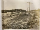
Here are some the aerials. Note you can see the Maurice river and the Manumuskin as well as schooner landing rd being the main road into the sand plant. Port Cumberland rd is seen in the distance before Whibco was present.
Those are very cool. I tried to roughly match them up to the NJGIN aerials from the 1930's (exact dates of that imagery rather vague). The c1949 USGS topo is probably the best map reference. Here are the first 3 images, the others are pretty similar in terms of view.
https://boydsmaps.com/#18.00/39.346214/-74.971970/njgin1930/-10.20/60.00
Here's the topo
https://boydsmaps.com/#18.00/39.346214/-74.971970/pines1949/-10.20/60.00
(this screenshot is zoomed out three clicks to make it readable)
This is the second picture
https://boydsmaps.com/#16.50/39.350506/-74.974309/njgin1930/87.00/60.00
And the third picture
https://boydsmaps.com/#18.50/39.349249/-74.972773/njgin1930/168.60/59.20
This is another way to compare features (although you can't tilt and rotate the map)
https://boydsmaps.com/sync/#15/39.346214/-74.971970/njgin1930/0/0/pines1949/15/0/0
Ben, yes that sand rd that heads south does end up At Barth rd but it comes out in someones back yard.To get to the rd you have to slip around their house to the left or right.There is another rd that parallels it and joins it that would start in the bottom right corner of that photo and parallels close to 55 most of the way before it bends left toward barth rd
Okay, yes, now I see why.Oh no, it definitely was a problem! Fine anthracite coal was not readily burned in standard fireboxes during the 19th Century, and was dumped together with waste rock in enormous heaps called "culm piles". From here, of course, the coal fines washed into rivers draining the coalfield, such as the Susquehanna, the Lehigh, and the Schuykill--"paved with derelict coal", says Henry S. Canby of the last. As the technology developed and mining became more expensive, it became possible to reclaim the culm piles, but that still left the coal washed into the rivers. There were quite a few of these coal-dredging operations, usually small and somewhat ramshackle enterprises. On the lower Susquehanna, the pools of the hydroelectric dams acting as settling basins for the coal fines; Holtwood Dam had an accessory power plant built to burn dredged river coal to augment the power from the turbines.

How Coal Affects Water Quality: State of the Science | Sightline Institute
After a recent spill at a British Columbia marine coal export terminal, the general manager was quoted in a local newspaper saying: There’s a lot of misinformation around coal. Coal is a naturally-occurring mineral. It is not toxic. Leaving aside his non sequitur—plenty of naturally-occurring...
 www.sightline.org
Visitor’s cars 1937 meeting
I am working on uploading the rest of the photos today. Hopefully there are no doubles. Out of these 4 albums a lot of them are the same pictures. I will also add some captions eventually. There pictures description list based on the number written on the back of the photos just give me some time.
Last edited:
#9 storage sheds-Mr. Wolf-One truck
#9 gravel storage NW view
#2 bank-dredge far right center-men on walk
Stripping. Bill Ahlquist Shovel-Broadie truck
#7 Mullers. mr. Wolf and Greenie.
#7 Lee Taylor-close up 2 mullers
one shovel and bank
#2 Scow-Cutter-Ohlson and two on board
#6 loaded cars two dumps
Machine shop and garage John Moore Jr by welder "Doc" George Herbert Sr. with sprocket
Group picture 1937 meeting. another caption reads: Plant visitation New Jersey Silica Sand Co. Millville NJ June 11, 1937.
Auspices of
American Foundrymen's Association Philadelphia Metropolitan Chapter
#1 Millville molding sand
#2 Albany molding sand
dry storage
Last edited:
Caption for man standing in woods with hat removed reads as follows: Old pit-mined by Pipe Co.
Caption for man in laboratory: Laboratory-Nelson Bailey.
Great stuff. That company projected a great knowledge in what they were selling, and in how to get it and sort it.
Millville and Vineland were straight up barrens at one time.You can still see it in the woods that are left in some areasThis photo is very cool having walked those tracks many times. Assuming this is all the ruins by the osprey nests about 1-2 down from port Elizabeth road.
South jersey always looks so much more piney in any old photos, especially in Deep South jersey.
Al, certain spots do look core barrens ish still like behind menatico ponds, along 55 near Sherman ave and a few other spots. Just always wonder if sections of Cumberland at one time looked no different than areas in Chatsworth for example. Saw an old photo of belle plain and it looked like the plains on 539. If I had one super power it would be to go back in time to see what areas use to look like and the species that inhabit them.
Al knows that I still want to do a plant survey on this little peninsula of sand that juts out into a flooded sand mine down there. We were exploring there about 15? years ago. We walked up to this oddity through a forest clearly not pine barrens, and suddenly came upon a little peninsula with a shocking conversion to something you'd see along the Wading River. I think this is it below. Wide view first to show the location relevant to NJ.


These are the last 2 photos that were in the albums. They appear to be at a port somewhere may be unloading sand from the rail cars and loading the ships. The ship names look like F.W. Gwinn of New York and Four Jims