Medford may straddle the path. Never a good thing for them. They pen up all that water for the lakes, which stresses the dams.
RAIN?
- Thread starter dogg57
- Start date
You are using an out of date browser. It may not display this or other websites correctly.
You should upgrade or use an alternative browser.
You should upgrade or use an alternative browser.
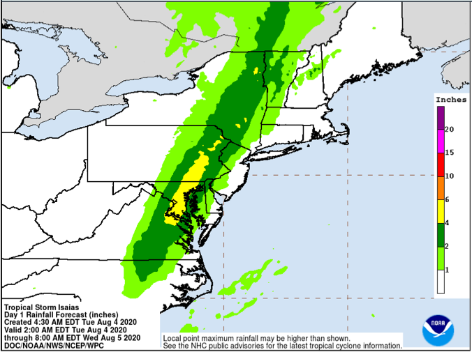
The rain totals have been lowered for my location, they are predicting a maximum of 2.5 inches now. But Medford has a forecast of 4.5 inches maximum.
I am in the 4 to 6 very edge. When we get that amount of rain I have trouble getting to and from work. One time I traveled in circles for 15 minutes trying to figure out a way in. Where I work was forced to buy flood insurance as we are in a flood plain. We even had to fill in the loading dock hole with concrete to keep the insurance people happy.
Haven't had any rain at all here yet, kind of surprised. And according to the new projection, we may not get any. The wind could be a problem though.
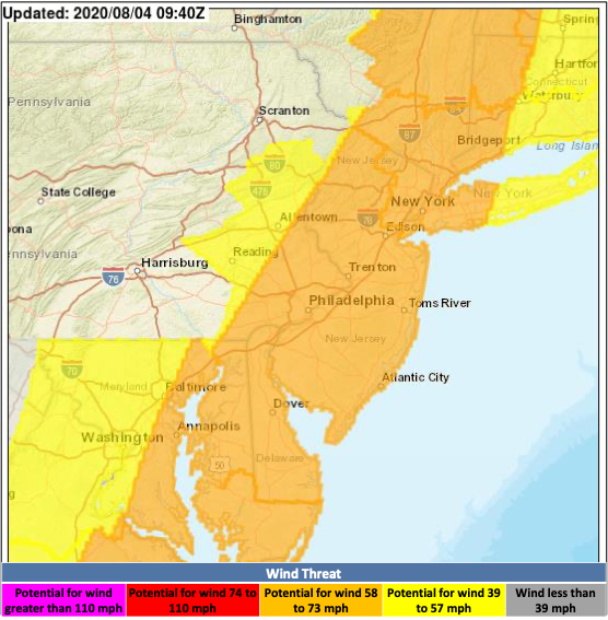
Whatever it turns out to be, be safe everyone. Right now tornado warnings just went up in the Upper Darby area.
I just saw this. Looks like we're in a SOE.

 www.nj.com
Gov. Murphy declares state of emergency as Isaias becomes a hurricane
Damaging winds, flooding and thunderstorms were forecasted to batter much of the state from daybreak Tuesday.
Got the tornado alert on my phone, fortunately nothing happened. They had some big problems in Delaware, were reporting a line of tractor trailers laying on their sides on the highway.
Had about an hour of rain here, then heavy winds. Calmed down a bit now but still some strong gusts. Was watching local news (first time in years) and got a chuckle from this. How often to you see an alert for Harrisville?
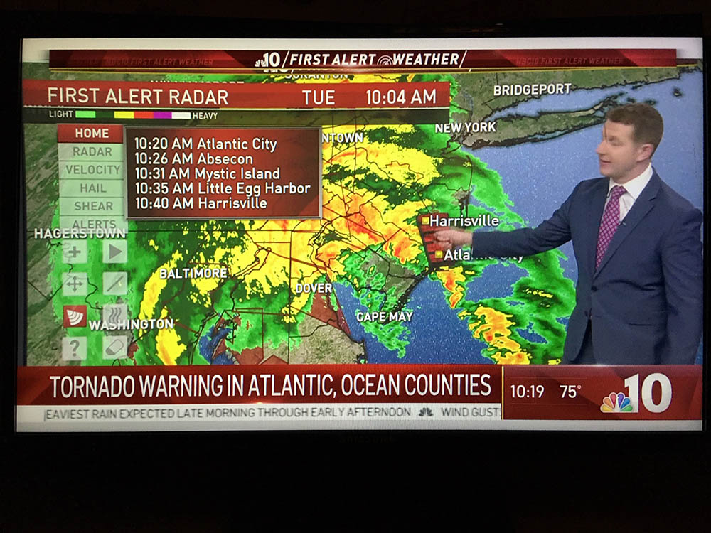
Had about an hour of rain here, then heavy winds. Calmed down a bit now but still some strong gusts. Was watching local news (first time in years) and got a chuckle from this. How often to you see an alert for Harrisville?

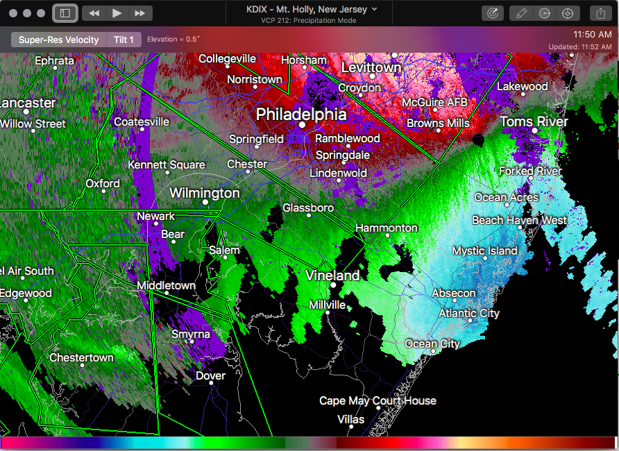
Have been getting scary wind gusts here, but (hopefully) the storm is moving North and winds are dying down now. Here are the current winds. The purple areas are ~100mph, light blue in the 60-70mph range and greens in the 30-50mph range. These may not apply to ground level conditions however.
And now it's gone, like a switch was turned off. Dead calm and the sun just came out... hope it lasts. 70 degrees with 90% humidity, should get miserable as soon as it warms up. Hope everyone else is OK, didn't last long but those wind gusts were about as strong as I've ever seen. At one point I heard a loud BOOM! and was a bit scared, until I found it was the guest room door blowing closed. 

Last edited:
The heavy stuff is just moving into my area now, it's dark as night, lots of thunder and rain is pouring down. Wind is just starting to blow. Nice to have a cool morning for a change though. Looks like we're in for a bunch more rain right through tomorrow.
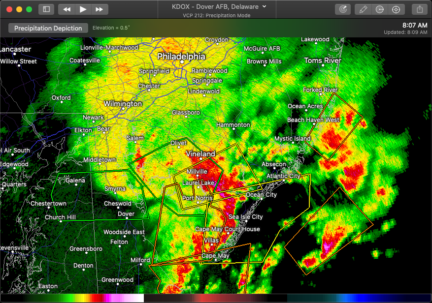
BULLETIN - IMMEDIATE BROADCAST REQUESTED
Severe Thunderstorm Warning
National Weather Service Mount Holly NJ
804 AM EDT Thu Aug 6 2020
The National Weather Service in Mount Holly NJ has issued a
* Severe Thunderstorm Warning for...
Southeastern Atlantic County in southern New Jersey...
Southeastern Cumberland County in southern New Jersey...
Cape May County in southern New Jersey...
* Until 845 AM EDT.
* At 804 AM EDT, a severe thunderstorm was located over Dennisville,
or 13 miles west of Ocean City, moving east at 35 mph.
HAZARD...60 mph wind gusts and penny size hail.
SOURCE...Radar indicated.
IMPACT...Damage to roofs, siding, trees, and power lines is
possible.
* Locations impacted include...
Atlantic City, Ocean City, Cape May, Pleasantville, Somers Point,
Ventnor City, Margate City, North Wildwood, Wildwood Crest,
Woodbine, Sea Isle City, Estell Manor, Avalon, West Cape May,
Longport, Stone Harbor, Corbin City, Cape May Court House, Scotch
Bonnet and Beesleys Point.
This includes the following highways...
Garden State Parkway between mile markers 0 and 31.
Atlantic City Expressway between mile markers 0 and 1.
PRECAUTIONARY/PREPAREDNESS ACTIONS...
Protecting yourself from immediate threats to life and safety shall
take priority. Whenever possible, as long as it does not cause
greater harm, all COVID-19 protective action guidance should be
followed.
For your protection move to an interior room on the lowest floor of a
building.
To report severe weather, contact your nearest law enforcement
agency. They will send your report to the National Weather Service
office in Mount Holly NJ.
In addition to large hail and damaging winds, frequent cloud to
ground lightning is occurring with this storm. Move indoors
immediately. Remember, if you can hear thunder, you are close enough
to be struck by lightning.
Torrential rainfall is occurring with this storm, and may lead to
flash flooding. Do not drive your vehicle through flooded roadways.
&&
LAT...LON 3922 7427 3910 7447 3893 7459 3892 7501
3929 7496 3940 7426
TIME...MOT...LOC 1204Z 263DEG 31KT 3922 7485
HAIL...0.75IN
WIND...60MPH
Our power went Tues when a departing gust pushed a pine tree onto our neighbors pole barn, bringing down the power line. We noticed this when the 20 foot length or wire on the ground was on fire and the pole barn also caught. Fire dept took care of the fire. We were able to borrow a friend's generator yesterday to run a window ac.
We called Atlantic Electric, and didn't expect restoration until Fri or Sat since our outage only affected 5 households. Had a chat with AE guy in a bucket this afternoon, first time they were in our area. He was familiar with our street, also the guy they sent to do assessment this morning got stuck in mud in the alley and had to be towed out. They heard him on the radio; he's in for some chop busting.
Later this afternoon there was a tree crew here, removed the fallen tree, then 3 repair trucks. New power line took about 2 hours, back on line about 6pm.
I heart AE.
As of this month I'll be on AC electric. I thought it was odd...I'm moving from Bamber to Barnegat, and I have to switch electric companies (JCPL to AC). Gee, I'm still north of the Mullica.
Something to look forward to. 
"NOAA's updated 2020 Atlantic Hurricane Season Outlook indicates that an above-normal hurricane season is very likely, with a significant possibility of the season being extremely active. The outlook indicates an 85% chance of an above-normal season, only a 10% chance of a near-normal season, and a nominal 5% chance of a below-normal season.
- - - - -
This updated outlook calls for a 70% probability for each of the following ranges of activity during the 2020 hurricane season, which officially runs from June 1st through November 30th:
19-25 Named Storms, which includes the nine recorded named storms during May-July
7-11 Hurricanes, which includes two hurricanes to date
3-6 Major Hurricanes
- - - - -
The season is now expected to be one of the more active in the historical record. The centers of the predicted ranges of named storms, hurricanes, and major hurricanes (22, 9, and 4.5, respectively) are well above the 1981-2010 seasonal averages of about 12 named storms, 6 hurricanes, and 3 major hurricanes."
