RAIN?
- Thread starter dogg57
- Start date
You are using an out of date browser. It may not display this or other websites correctly.
You should upgrade or use an alternative browser.
You should upgrade or use an alternative browser.
My wish from post #1092 may be coming true.
Well, I'd like some rain, but I don't "wish" for a hurricane. Even in a weakened state we could have high winds, downed trees, power outages and flooding. But of course, nature couldn't care less what any of us wants.
Well, I'd like some rain, but I don't "wish" for a hurricane. Even in a weakened state we could have high winds, downed trees, power outages and flooding. But of course, nature couldn't care less what any of us wants.
Neither did I. I stated in post #1092 that "...unless we get a few 2" rain events spread out over 4-5 days at a shot, or get the remnants of a tropical depression on top of a few rainy days, we're going to stay pretty deep into it. Still hoping for some rain bands from a TS sometime in the next few weeks."
In post #1100 I wrote "Out of respect for others in the path I'm not cheering on a hurricane, but if Ian drops some good rain on us I won't be unhappy about that."
I never "wished" for a hurricane. Just wanted to be clear on that.
It looks like the rain will be Friday, Saturday and Sunday.
Guess it's still too early to know, but seems like we won't get any of this until later in the weekend. The current NWS forecast says cloudy on Friday, 40% chance of rain Saturday and 50% on Sunday.
As of now, computer guidance models are spitting out different scenarios, so there are wide disparities in the timing of the rain. “There’s some question during this time period for Saturday, Sunday and Monday of how long it’s gonna take the remnants of this hurricane to reach our area,” DiMartino said. “Some guidance brings it in on Saturday, some guidance brings it in on Tuesday of next week.”

Will Hurricane Ian bring heavy rain to N.J.? Here’s what forecasters are predicting.
Hurricane Ian is expected to intensify into a major storm in the next two days before it takes aim at Florida.
Last edited:
I have a gut feeling it might go out to sea before making it this far north.My wish from post #1092 may be coming true. I hope that any impact to those in the Southeast is minimal. Out of respect for others in the path I'm not cheering on a hurricane, but if Ian drops some good rain on us I won't be unhappy about that.
View attachment 18211
Hazardous Weather Outlook
National Weather Service Mount Holly NJ
316 AM EDT Tue Sep 27 2022
New Castle-Kent-Inland Sussex-Delaware Beaches-Kent MD-Queen Annes-
Talbot-Caroline-Sussex-Warren-Morris-Hunterdon-Somerset-Middlesex-
Western Monmouth-Mercer-Salem-Gloucester-Camden-
Northwestern Burlington-Ocean-Cumberland-Atlantic-Cape May-
Southeastern Burlington-Carbon-Monroe-Berks-Lehigh-Northampton-
Delaware-Philadelphia-Western Chester-Eastern Chester-
Western Montgomery-Eastern Montgomery-Upper Bucks-Lower Bucks-
316 AM EDT Tue Sep 27 2022
This Hazardous Weather Outlook is for central Delaware, northern
Delaware, southern Delaware, northeast Maryland, central New
Jersey, northern New Jersey, northwest New Jersey, southern New
Jersey, east central Pennsylvania, northeast Pennsylvania and
southeast Pennsylvania.
.DAY ONE...Today and tonight.
No hazardous weather is expected at this time.
.DAYS TWO THROUGH SEVEN...Wednesday through Monday.
The probability for widespread hazardous weather is low.
I have a gut feeling it might go out to sea before making it this far north.
It may, but if it does make it this far north, it may also join forces with the already existing low-pressure system expected for the weekend and dump a good amount of rain on us. Again I'm not cheering this on, this is one of the most powerful hurricanes in a long time. The water has been pushed out of Tampa Bay at this point (it's freaky, check it out if you get a chance), and Ian is just 2 mph short of a Cat 5 (at least it was a few hours ago when that was reported). They are expecting 12-18 (!) foot storm surge and up to 24 inches of rain in some areas (yes you read that right). Parts of Florida are about to be decimated and I'm definitely hoping for the best outcome for all affected.
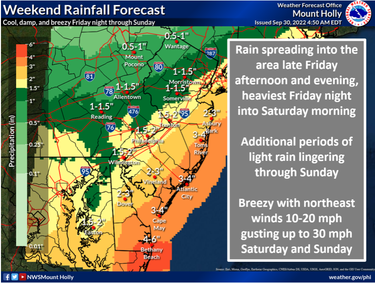
Regarding what might happen here, I'm looking at the updated rainfall predictions. It's noteworthy that the track has shifted slightly west, and extrapolating the following graphic, we are looking at a bit more promising scenario for rain. I know that most of NJ is not on this map, but the track of the 4-6" (yellow) line was east of this yesterday. Note that Cape May is in the 4-6" range at this time.
Pretty similar to yesterday's forecast with a little more rain to the West. The good thing is that the wind forecast has dropped, with 30mph gusts instead of 40mph.

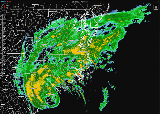
Here it comes.... it's a big one!  Heading out for a quick walk before it gets too wet.
https://boydsmaps.com/#7.00/36.205993/-76.655054/conus/0.00/0.00

 Heading out for a quick walk before it gets too wet.
https://boydsmaps.com/#7.00/36.205993/-76.655054/conus/0.00/0.00


