Rancocas State Park ruins?

I live next to the Rancocas State Park and have seen these bricks, foundations, and an awesome stairway built into the side of a hill along the rancocas creek. I have been told by family who have lived in and studied the area for years, that they were summer homes for philadelphians, but havent been able to find any information about this in books or the internet. There was also supposed to be a mansion located on Breezy Ridge, along the north branch of the creek, however I still havent found any indications that a building has been there or any information in print/online.​
Has anyone ever heard of these homes? There are pictures attached of the stairs and of the other sites, located right around where the rancocas creek splits into north and south branches. There is also a map attached with the approximate locations of the sites. Any information is greatly appreciated!​
 

Attachments

  • Rancocas Ruins (2).jpg
    Rancocas Ruins (2).jpg
    1.8 MB · Views: 2,012
  • Rancocas Ruins.jpg
    Rancocas Ruins.jpg
    1.8 MB · Views: 2,870
  • RSP map.jpg
    RSP map.jpg
    932.7 KB · Views: 2,997
  • Rancocas Ruins!.jpg
    Rancocas Ruins!.jpg
    1.7 MB · Views: 4,553
The Forks of the Rancocas is a fabled land that hosted the large native town known as Remkokes before European settlers ever arrived on the creek to take up parcels for agrarian pursuits. In 1670 the Bohemian Augustin Herrman toured Maryland and Virginia and what would become Delaware and West New Jersey. In 1673, a cartographer produced a map of Herrman’s findings:

Herrman detail.jpg


In another part of his map, Herrman noted that what would become West New Jersey was “At present Inhabited Only or Most by Indians.” At that time, the ground surface on top of the peninsula towered 30' above the creek:

Vermeule 1878.jpg


The earliest major European landowner on this peninsula I have identified to date was Daniel Wills Jr., whose father settled on the north shore just downstream from the Forks. Through a gift of unlocated lands from his father’s proprietorship, Daniel Jr. obtained a warrant to have 480 acres located at “The Forks of Ancokus.” Daniel strengthened his holdings at The Forks by purchasing another 100 acres from Henry Mosley in 1697. Daniel remained tenured in the tract until he gave his son James Wills 200 of the original 480 acres. It is unclear whether Daniel or James ever constructed a residents on the peninsula or just used the land for grazing cattle and sheep.

The land passed down through and then out of the family during the ensuing 30 or so years until Charles Read purchased 40 acres at The Forks in 1747. Between the years 1754 and 1758, he added to his holdings at The Forks through a 256-acre acquisition from Andrew Conarro for £163 and 234 adjacent acres from John Erwin for £400. These two parcels comprised Read’s plantation known as Breezy Ridge. In his biographical account of Read, author Carl Raymond Woodward notes:

From the limited evidence at hand it appears that Breezy Ridge was a pretentious establishment. The substantial hip-roofed house looking southward across the stream stood on an eminence exposed to the breezes that swept up the Rancocas Valley. Nearby stood a boathouse marked with the initials C.R. There is mention of “Read’s Dam,” also, on the South Branch of the Rancocas which may have been nearby. Five islands in the Rancocas, totaling 6½ acres in area, also were acquired in 1756—one by purchase, the others by survey under one of Read’s proprietary grants.
Although the precise place of Read’s residence through these years is not certain, there is evidence that for a time he lived at Breezy Ridge—he is referred to in deeds given in 1760 as “Charles Read of Breezy Ridge.” Perhaps he maintained his Burlington home and Breezy Ridge simultaneously, using the latter as a summer retreat.
The entries in Read’s notes indicate unusual agricultural activity from 1756 to 1758. Presumably Breezy Ridge was the locale. Experiments as diverse as the seeding of millet, the grafting of fruit and the feeding of cattle were recorded during these years. That stumpy grafts were superior to slender ones he found to be “strickly [sic] by Experim[en]t.”
On selling 20 cattle he had fattened on grass, he made a profit of £57. On harvesting his hay crop in 1756, he noted the capacity of his barracks, and also computed the weight of hay per cubical unit. When he butchered his hogs in 1757, he noted carefully the lost in weight of the dressed carcasses. No step in the day’s work on the farm was too small to escape his attention.
Again at Breezy Ridge, Read experienced the common vexation of runaway servants. In the Pennsylvania Journal for August 17, 1758, appeared an advertisement offering 20s. reward for an Englishman named Joseph Dealy—who ran away June 7 “from the plantation of Charles Read, Esq., at Breezy ridge in Burlington County.” The advertisement was signed by Hugh Dunn, who may have been Read’s tenant, or the superintendent of the plantation.

…Much of the soil on Breezy Ridge was light and sandy, not so suitable for the growing of grain and grass crops as for sweet potatoes and other vegetables. Coveting for the cultivation of crops the rich but undrained marshlands that bordered the plantation, Read engaged on Thomas Rakestraw to ditch and bank the meadows on the north side of this branch of the Rancocas. The terms of the agreement reveal a creditable knowledge of agricultural engineering, which is evidenced also by the description of the water engine in Read’s notes. The bank was the kind “Commonly Called twelve by Four” (presumably 12 feet wide at the base and 4 feet high), “the ditch to be Out side and a five-feet Drain behind the Bank with the necessary Sluices, and always hereafter shall be repaired made and amended and Skoured & Other necessary work Done for keeping the Same Dry.” In 1761 Read sold Breezy Ridge to Thomas Bispham of the town of Gloucester.

In his book, Woodward supplies a map of how the Breezy Ridge Plantation appeared:

Breezy Ridge Map.jpg


Thomas Bispham remained tenured in the Breezy Ridge property until his death in 1776. In September of that year, Bispham’s executors sold the plantation to John Woolman’s younger brother, Uriah, for £1450. Born near Rancocas in 1728, Uriah Woolman was a successful Philadelphia iron and steel merchant for many years until he decided to retire to Breezy Ridge. He retained title to the property until his demise in 1804. Since Uriah had no children of his own, he devised his Breezy Ridge lands to 12 nephews, who sold off portions of the land on the peninsula. At some point in time subsequent to the nephews selling land there, probably between 1804 and 1820, John Bishop acquired approximately 174 acres of the Breezy Ridge plantation, including the dwelling house facing the South Branch that Charles Read had constructed. John Bishop also purchased a farm in Mansfield Township and soon relocated there, leaving his son, Joseph Ridgway Bishop to occupy Breezy Ridge. The 1849 Otley and Whiteford cadastral map of Burlington County depicts the landowner as “J. Bishop,” which could be either John or Joseph Bishop:

1849 detail.jpg


Joseph and his wife, Hannah Haines, had two daughters: Ann, who married William Johnson; and Lydia, who married Abraham Van Sciver on 26 January 1860 at the Baptist Church in Moorestown. When John Bishop drafted his Last Will and Testament, he devised Breezy Ridge farm to its occupants, Joseph Ridgway Bishop and his wife, Hannah, as joint tenants with rights of survivorship. The 1859 Parry, Sykes and Earl map of the county features a label for J.R. Bishop within The Forks:

1859 detail.jpg


Joseph Ridgway Bishop predeceased his father, but John made no changes to his Will. On 2 December 1863, John Bishop died and Hannah Haines Bishop, Joseph R.’s widow, gained full ownership of Breezy Ridge farm, devised to her by her father-in-law.

Less than three months later, Hannah conveyed the farm to her daughter, Lydia:

For and in consideration of the sum of one dollar and the natural love and affection she hath for her daughter,” Hannah Bishop deeded to her daughter “The farm, plantation or tract of land called and known by the name of Breezy Ridge situated in the Twp. of Lumberton Burl. Co., Containing 165 79/100 acres more or less. Also another tract of land containing 8 acres more or less. Subject never the less, the 8 acres to the following conditions, that is that Hannah Bishop in during her natural life to have and occupy and enjoy the 8 acres of land as may seem to her best without any hindrance or molestation from her, Lydia Van Sciver, or any other person acting under the authority and not suffer for the use of any firewood or any other thing while living or to any incumbrance to her other daughter Ann Johnson, wife of William Johnson by reason where of that Anna Johnson is to suffer any loss or expense incurred for Hannah Bishop’s good and comfortable maintenance.

This transaction provided Abraham and Lydia Bishop Van Sciver with a place to live and raise their family. The marriage produced five children: Joseph Bishop Van Sciver; George Dobbins Van Sciver; Abraham D. Van Sciver; Annie Van Sciver; and Mary Carlisle Van Sciver. Abraham contracted pneumonia and died in January 1871. Subsequent to Abraham’s death, Lydia remarried to William Amos. The couple had two children together: William and John Amos. The J.D. Scott 1876 Combination Atlas Map of Burlington County depicts not only Lydia with her new married name, but also the presence of a second dwelling in the Forks: the home of William A. Johnson and his wife Ann, Lydia’s sister:

1876 detail.jpg


During the second half of the 1880s, a group of investors purchased the central eastern portion of the peninsula formed within the Forks and platted a new subdivision named “Riverdale.” The company prepared a map of their holdings, which delineates streets and building lots and labels Lydia’s house as the “Amos Residence,” as shown in the detail below from the development map:

Riverview Amos House detail.jpg


The map also featured a statement confirming the high bluff overlooking the creek:

Riverview, High Bluff.jpg


The center section of the map illustrates that the building lots lay above Breezy Ridge Farm and nearer to the North Branch as well as two planned lakes for the recreational use of the prospective residents:

Riverview site plan.jpg


While potential householders did purchase building lots, development at the Riverdale site grew very slowly. Grading efforts in December 1894 uncovered two Indian skeletons buried long ago. Lydia remained in possession of her Breezy Ridge Farm until her death in February 1902. She died intestate, so the Burlington County Orphans Court determined her children would share and share-alike in their mother’s landholdings.

The year before their mother’s death, J.B. and his brother, George, formed the Hainesport Mining and Transportation Company on 22 March 1901. This company sought to profit from the construction sand and gravel lying along the banks of the Rancocas. Mined by various companies since at least the 1880s, the lands surrounding Rancocas Creek contained a variety of sand types ranging from water filtration and building sand to foundry molding sand. The Van Sciver brothers began business with $50,000 in capitalization, but a year later, they doubled that amount. The rising hikes in capital continued through at least 1909, when the corporation issued stock valued at $600,000. Among other sand-bearing lands, the Hainesport Mining and Transportation Company acquired all of the land at the Forks. J.B. Van Sciver served as his administrator for his late mother’s intestacy and in August 1905, J.B. and all of the other heirs of Lydia Amos’s estate sold multiple parcels of land in the Forks, including building lots in Riverdale, to the Hainesport Mining and Transportation Company for the nominal price of $1.00. The company then began sand-mining operations and, in the space of six to eight years, destroyed the lofty 30-foot-high Breezy Ridge plateau, creating a virtual moonscape across the area. Many Indian artifacts from the village that once occupied the bluff in the Forks disappeared into the sand scows belonging to the company, never to be seen again.

In a 1910 report to Congress concerning conditions and the need to expend improvement funds on the Rancocas Creek, the United States Army Corps of Engineers states the following:

The banks of the Rancocas and of both of its branches contain immense deposits of building, filter, and molding sand. The deposits along the main stream and the Lumberton branch have been largely developed, while those up the Mount Holly branch have been hardly touched, owing to lack of navigation. The sand for some of the filtration works of Philadelphia, to the amount of 268,000 tons, was secured from beds located much more conveniently for shipment by water via the Mount Holly branch than by rail, but followed the latter route as scows and tugs of sufficient size could not go above the forks. It is estimated that the amount of sand transported from the Lumberton branch and from below the forks amounts annually to over 600,000 tons, of an average value of $1.

The same report contained letters of testimony from various businesses that would benefit from improving navigation on the Rancocas, including one from George D. Van Sciver of the Hainesport Mining and Transportation Company:

…Letter of the Hainesport Mining and Transportation Company
Hainesport, N.J., April 5, 1909
We believe that the river should be deepened at various places and straightened at some points above what is known as the forks or the junction of the south and north branches of the river. We find it very difficult to get our lighters and tugs to our sand banks at Hainesport, N.J., on an average run of tide, and on a very low run of tide impossible at times for a period of one to three days to move them at all. This condition makes the cost of getting material to Philadelphia and other points greater on account of increased freight charges.
Below you will find the quantity of gravel we carried out of the river, and its cost, during 1908: 867 boat loads carrying an average of 300 cubic yards each at 40 cents per cubic yard, which includes the cost of material, making $104,040. Carried to Hainesport from Philadelphia, 4,000 tons of pig iron at 43 cents per ton, $1,892.
Our business as well as others should be largely increased should we have a deeper waterway and a straighter channel. We believe that if this were to be accomplished manufacturing plans would be erected on the banks of the river as they would be able to avail themselves of the low rate which could be provided.
Hainesport Mining and Transportation Company,
Geo. D. Van Sciver, President.

It appears sand-mining operations in the Forks ended between 1911 and 1913. Van Sciver’s company had already acquired sand-bearing lands elsewhere along the creek, principally in Chester and Willingboro townships. While the Van Scivers shipped many barges of construction sand to Philadelphia, destroying the evidence of past historic and prehistoric habitation, they did not raze any of the buildings, including the old Charles Read dwelling. That succumbed to fire during the 1920s.

During the 1960s, the State of New Jersey acquired land in Westampton, Hainesport, and Mount Laurel townships to create the Rancocas State Park, including the land in the Forks. The state retains title to this land today as part of its statewide park system, although New Jersey has failed to develop the land for recreational activities or as a Wildlife Management Area. Today, the land within the Forks remains virtually as the Hainesport Mining and Transportation Company left it, except for the vegetation that has grown during the intervening years. Mounds dot the landscape in various locations around peninsula, formed when the sand-mining operations removed the overburden and turf to expose the underlying sand.

Best regards,
Jerseyman
©2013 All rights reserved
 

Teegate

Administrator
Site Administrator
Sep 17, 2002
25,602
8,181
I haven't read it yet and I like it! I will read it tonight.

Guy
 
Jerseyman, thank you so much!!! Boy howdy, I havent been able to find any information on hainesport, besides just one tiny book from the library, and what you have provided is a goldmine! Much of this is new information to me. I had heard of the scivers and the sand mining company, and a little bit about breezy ridge, but am glad to see that some of the info comes back from the late 1600's. Its wild to think that the peninsula was 30' over the creek! Thanks again for the response, it is so much more than I had hoped for! Finally, I am starting to learn more about the state park I have lived next to for almost 15 years.
 

bobpbx

Piney
Staff member
Oct 25, 2002
14,153
4,258
Pines; Bamber area
Really good research. I always smile when I see the name "Uriah". It is such a fanciful name. Brings to mind a guy that is out there on the edge.
 
Got out there with the kid two weeks back. GREAT hiking, and found some evidence of the old buildings at various spots (having the topo map helped me know where to look).

img_7839.jpg


There was evidence of the sand mining all over the place. Wouldn't have known what it was without Jerseyman's history.

img_7964.jpg
Definitely a great spot, the park is big enough that you feel like you're getting away from things. It's no "I've been driving down dirt roads in Wharton for an hour" getting away from things, but I really enjoyed it.

More pictures for anyone who may be interested - http://southjerseytrails.wordpress.com/2014/04/19/rancocasstateparksouth/
 
  • Like
Reactions: ElleJay

jokerman

Explorer
May 29, 2003
337
12
Manasquan
So interesting, thanks for the hard work and time to bring the summary to us. The destruction is always so sad but its a common theme in most NJ places.
 

Wreckless

New Member
Jan 9, 2009
19
4
Ocnaled
Across the creek in the Centerton section of Mount Laurel there was a phosphorous factory that made matches. Old timers told me about it as my house was nearby. Housing development has obliterated much in the area. Also across from the park was an amusement park in Rancocas Woods. My grandmother told me how she went there. She also called the area Texas because of all the sand and wild cactus growing. The cacti are still there,btw and grow close to the ground.
 

deathproof13

New Member
May 19, 2012
5
0
mount laurel
There's a lot of brick ruins in the Mt Laurel side of the park. Across water in the Hainesport side is an abonneded building. I think it use to be a park ranger building or a hunting lodge? Not sure...
 

ElleJay

New Member
Jan 21, 2023
1
3
California
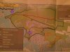
Hello all, I live out in California but have been researching my family tree and looking up things in this area for many years, since my ancestors settled in this area in colonial times, and I am wondering if anybody has came across Thomas Rakestraw's gravestone (same Thomas Rakestraw mentioned in Jerseyman's awesome local history post) or if they've seen any old cemetery near an old saw pit or may know where he lived based on some of the descriptions I have, as his later property sales somehow aren't recorded, but I presume he was neighbor or was near Breezy Ridge, since he or his wife (Elizabeth, nee Zane) sold some land to Charles Read 1758 on the North side of the South Ancocus, but he also had his will saying his property line was next to Joseph Moore's place: "1773 Dec 6. Rakestraw, Thomas, of Evesham, Burlington Co., cordwainer; will of. My body to be buried on my own land near an old sawpit, by the line of Joseph Moore's land, at which place I reserve a piece of 30 feet in length and 25 in breadth, which I order not to be sold or conveyed away, as long as the water runs in Delaware River, but to be kept for a burying place for my family forever. Wife, Elizabeth, to be well provided for on the place, and she is to keep son, Job, 2 years after my decease, but, if she marry, my friend and trustee, Isaac Evens, is to take him. I would have her to keep my youngest son, Paul Chalkley, till he is 8 years old. Son, Thomas, plantation where I live; and to his brother, Abram [...]" Here's the property entry from NJ State Archives about the land he sold to Charles Read, which makes me think he must have been his neighbor, if still doing things for him and the map Jerseyman provided in his post, fits the description:

Rakestraw, Thomas (ux) (Grantor)
TO: Charles Read
FROM: Thomas Rakestraw (ux)
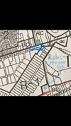
CONVEYANCE. North side south branch Ancocus Creek, Burlington County.
OTHERS NAMED:
LOCATIONS: West Jersey; Burlington; Ancocus Creek
16 Feb 1758

The land sale above may have actually been from land he had procured by marrying first wife, (Mary, nee Mason) since that sale coincides with around the time she passed away in 1757.

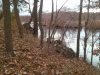
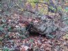
Any help on finding where he and his 30 x 25 ft. family burial plot may be, or to narrow down, would be greatly appreciated!

Thanks in advance,

~Lisa "ElleJay"
 
Last edited:
Top