Sea Breeze/Delware Bay, NJ

MikeNJ82

New Member
Nov 11, 2008
8
0
Hello all,

I stumbled across this fourm and it seemed really interesting, a big "whats up" and happy to be here....

I noticed a few posts on Sea Breeze, NJ along the Delaware Bay. I'm really looking to check it out to do some photography and had a few questions for any members that may have traveled there before:

1. Is there public parking? (I don't want to inadvertently park on someone's private property).

2. Is it safe? (road-wise I guess).

3. Are the locals hostile to outsiders visiting?

I ask about locals being hostile because I do not want them to think I'm some Weird NJ-type that wants to go there to cause trouble/vandalize things, etc. I'm really just curious and want to take some great pictures, I'd completely respect the area and it's residents. Any help would be appreciated, thanks for looking!

-Mike
 

whippoorbill

Explorer
Jul 29, 2003
675
121
66
Bridgeton
Hello all,

I stumbled across this fourm and it seemed really interesting, a big "whats up" and happy to be here....

I noticed a few posts on Sea Breeze, NJ along the Delaware Bay. I'm really looking to check it out to do some photography and had a few questions for any members that may have traveled there before:

1. Is there public parking? (I don't want to inadvertently park on someone's private property).

2. Is it safe? (road-wise I guess).

3. Are the locals hostile to outsiders visiting?

I ask about locals being hostile because I do not want them to think I'm some Weird NJ-type that wants to go there to cause trouble/vandalize things, etc. I'm really just curious and want to take some great pictures, I'd completely respect the area and it's residents. Any help would be appreciated, thanks for looking!

-Mike

Mike,

There isn't any official public parking at Sea Breeze, but one can tuck himself off to the side of the main road heading to the bay. I always take the right at the fork located a hundred yards or so from the bay and park close to the reeds on the left side of the road. If you're familiar with the area, this is by the old tavern.

The road is safe. It tends to flood a bit during high tide, though.

I've not had problems with the few locals there. I'm always carrying a camera, often have my kids along, and carry a tourist/I'm-just-looking-around appearance. One time a local saw me while I was handling field-recording gear and he simply (and nicely) asked, "what contraption is that you got there, buddy?" I explained, we had a nice conversation, and off he went.

Bill
 

Kevinhooa

Explorer
Mar 12, 2008
332
25
41
Hammonton, NJ.
www.flickr.com
seabreeze

I checked out Seabreeze a couple of years ago in early March. It was super cold that day and I didn't see a soul out there. Parked on the side of the road and just walked around. Not really a whole lot to see, but it is a neat place. Try and get out there an hour or two before sunset on a partly cloudy day and you could get some great shots.

Kevin
 

MikeNJ82

New Member
Nov 11, 2008
8
0
Thanks Kevin for your input, I've heard it's pretty desolate in winter. It's one heck of a long drive for me from here, I'm in Union County, NJ up North and the mapquest directions are thru places that I'm not the least bit familiar with. I've hard that Fairfield and Bridgeton are rough towns and it sends me through both.. I guess I'll have to find out. The sunset on the water sounds like a great opportunity for photos however, thanks again.
 

Ben Ruset

Administrator
Site Administrator
Oct 12, 2004
7,619
1,878
Monmouth County
www.benruset.com
Thanks Kevin for your input, I've heard it's pretty desolate in winter. It's one heck of a long drive for me from here, I'm in Union County, NJ up North and the mapquest directions are thru places that I'm not the least bit familiar with. I've hard that Fairfield and Bridgeton are rough towns and it sends me through both.. I guess I'll have to find out. The sunset on the water sounds like a great opportunity for photos however, thanks again.

Why wouldn't it send you straight down the Parkway?

The only real "rough" towns in NJ are Newark and Camden, and *maybe* Asbury Park.
 

omega

Explorer
It's actually a nice drive. I'm going to Bridgeton next Thursday to videotape some interviews at the courthouse. It isn't a short drive even from Toms River, but once you get off the parkway I find it very enjoyable. Now that I think of it, it's an evening taping some I might make a side trip earlier in the day.
 

MikeNJ82

New Member
Nov 11, 2008
8
0
bruset: according to mapquest (who I sometimes don't trust), it sends me down the Turnpike to exit 3, then on a few other highways (the last being 56 West/Landis Ave) before putting me on the local back roads out to the pay. Being I live off the 130's on the parkway (and the Bay area is literally on the other side of the state from my house), not sure how I could take the Parkway in that ride, any ideas ?
 

Mts83

Explorer
Oct 24, 2008
207
1
Sourland Mountains
www.wtfda.info
Unfortunately (or fortunately for urban sprawl reasons) there is no direct route from the Atlantic City/Cape May area to the Millville/Vineland/Cumberland co area. The only routes are all two lane, US-40, CR-552, NJ-49, and NJ 47/347 (and some smaller roads). There was a proposal back in the 60s and 70's to build a NJ-60 freeway which would have connected Ocean City and Vineland, however that never happened. If it had, pristine areas such as Estell Manor, Weymouth, and Maurice River Township would have no doubt been destroyed by now with the available access. The same issue has been brought up with completing Route 55, though then again there would be major environmental impact. On the flip side of the coin, those two roads (if built) would/would have provided a fast route to the Cumberland county area.

That said, you can take the Parkway south from Union by taking Exit 44 (CR-575) to US 40 to 552 to get out there (575 has recently been signed with Millville mileages as a control city), however by far the best/easiest way is by taking the western route. I'd suggest taking the NJTP to 295 (connect at Exit 7) to 55 to 553. Take 553 through the countryside towards Bridgeton. When 553 turns near Bridgeton continue straight until it turns into NJ-77 south. Once in downtown Bridgeton continue straight through the light near the tall court building (right) and the KFC (left) which will eventually put you right back on 553 (553 will come to a T and a gas station will be on your left). The turnoff for Seabreeze is off 553.
(You can also just follow 553, though it circles around Bridgeton making the trip longer)

If you really want to avoid the turnpike/western route though, I can give you some additional directions if you’d like from the GSP. It’s longer, though more scenic as you get to see more of the pines.
 

RednekF350

Piney
Feb 20, 2004
5,051
3,320
Pestletown, N.J.
.

That said, you can take the Parkway south from Union by taking Exit 44 (CR-575) to US 40 to 552 to get out there (575 has recently been signed with Millville mileages as a control city), however by far the best/easiest way is by taking the western route. I'd suggest taking the NJTP to 295 (connect at Exit 7) to 55 to 553. Take 553 through the countryside towards Bridgeton. When 553 turns near Bridgeton continue straight until it turns into NJ-77 south. Once in downtown Bridgeton continue straight through the light near the tall court building (right) and the KFC (left) which will eventually put you right back on 553 (553 will come to a T and a gas station will be on your left). The turnoff for Seabreeze is off 553.
(You can also just follow 553, though it circles around Bridgeton making the trip longer)

If you really want to avoid the turnpike/western route though, I can give you some additional directions if you’d like from the GSP. It’s longer, though more scenic as you get to see more of the pines.


These are very good directions and will provide the most scenic route once you dump out of 55.
553 is a good road and it gives you the self guided tour of the Delaware Bay coastline with roads for diversions at each old coastal town.
The summers in my early dating years with my wife had many trips in the back of my brother-in-law's pickup down to the Turkey Point/Dividing Creek/Hansey Creek/Back Creek/Beaver Dam/Hollywood Beach and Nantuxent Creek areas for some of the most incredible crabbing you could ever imagine.
I fished out of Longreach at Bivalve for the first 8 years that I had my own boat but later shifted to Cape May.
553 is a good winter time ride with a sixer on the seat and stops at all the hidden towns along the way.
 

whippoorbill

Explorer
Jul 29, 2003
675
121
66
Bridgeton
553 is a good winter time ride with a sixer on the seat and stops at all the hidden towns along the way.

Yeah ... heed Scott's advice, Mike. Especially since you have to make the long haul from North Jersey. Start at Sea Breeze and hug the bay southward, using 553 as your road to access the treasures.

Bridgeton isn't a rough town. Plow on through at 100mph and the bandits'll all miss! I'm a typical citizen here, and have (only) been in and out of prison 16 times. (Gullible parole officers) :)

Ben's right; Camden's average is 32.

Good luck when you make the trip. Ignore any strange-looking field recorders tucked away in the reeds.

Bill
 

AJ1957

Scout
Apr 18, 2008
42
0
Man I gotta get out of Monmouth County more often. I was just looking over the Delaware Bay/River shoreline on Google and I must admit that I never knew there was so much of nothing down there. What gives? Too swampy to build on? I can’t believe there’s that much undeveloped shoreline in New Jersey. Looks like a beautiful area.
 

Mts83

Explorer
Oct 24, 2008
207
1
Sourland Mountains
www.wtfda.info
Yeah ... heed Scott's advice, Mike. Especially since you have to make the long haul from North Jersey. Start at Sea Breeze and hug the bay southward, using 553 as your road to access the treasures.

Bridgeton isn't a rough town. Plow on through at 100mph and the bandits'll all miss! I'm a typical citizen here, and have (only) been in and out of prison 16 times. (Gullible parole officers) :)

Ben's right; Camden's average is 32.

Good luck when you make the trip. Ignore any strange-looking field recorders tucked away in the reeds.

Bill

I agree, it's a great ride though those areas. Bridgeton is a little tough, though I've gone down Pearl St on a weekend summer night and survived, it isn’t that bad :ninja::) haha. Down along the bay is great- its a forgotten corner of NJ, feels like you're another state, and is comparable to somewhere down in bayou country. Fortescue, Turkey Point, Bivale/Shellpile, Money Island are all places you may want to check out (and others). There’s really too much to explore in one day... you never know what you'll run into along the bay... maybe even a "UFO" (some people who have explored around down there may know what I’m talking about lol)
 

MikeNJ82

New Member
Nov 11, 2008
8
0
Wow.. thanks to everybody.. I've got a few locations to plan out, hopefully before it gets too cold. I figure Bridgeton can't be as bad as our cities up North like Newark, Patterson and Elizabeth (Eliza-BIT in North Speak). It probably is a good thing they didn't connect the Bay area to those highways as they propose, it would have definitely been ruined by now, we've seen a lot of that happen up North. In any event, I'll keep everybody posted, thanks again for the great input and anybody else that wants to contribute thanks in advance!

-Mike
 

RednekF350

Piney
Feb 20, 2004
5,051
3,320
Pestletown, N.J.
I just got back from hauling a boat trailer up fom Delmont below Leesburg and I stopped out at East Point Lighthouse.
The bay is very angry today and should be very angry tomorrow with the frontal change.
Tomorrow would be a good picture taking day if you like rough seas in your photos.
Sea Breeze will take a pounding.
Here is the D-bay marine forecast for tomorrow.
Yaaaarh!

NZ431-152130-
DELAWARE BAY WATERS SOUTH OF EAST POINT NJ TO SLAUGHTER BEACH DE-
1233 PM EST SAT NOV 15 2008

GALE WARNING IN EFFECT THROUGH SUNDAY AFTERNOON

TORNADO WATCH 934 IN EFFECT UNTIL 7 PM EST THIS EVENING


THIS AFTERNOON
S WINDS 20 TO 25 KT WITH GUSTS TO 35 KT.
SEAS 2 TO 4 FT. SHOWERS AND POSSIBLE TSTMS.

TONIGHT
S WINDS 20 TO 25 KT WITH GUSTS TO 30 KT...BECOMING W
15 TO 20 KT AFTER MIDNIGHT. SEAS 3 TO 5 FT. SHOWERS WITH A CHANCE
OF TSTMS IN THE EVENING...THEN SHOWERS LIKELY AFTER MIDNIGHT.

SUN
W WINDS 20 TO 25 KT WITH GUSTS TO 35 KT. SEAS 3 TO 5 FT.

Scott
 

Kevinhooa

Explorer
Mar 12, 2008
332
25
41
Hammonton, NJ.
www.flickr.com
Not much there

Man I gotta get out of Monmouth County more often. I was just looking over the Delaware Bay/River shoreline on Google and I must admit that I never knew there was so much of nothing down there. What gives? Too swampy to build on? I can’t believe there’s that much undeveloped shoreline in New Jersey. Looks like a beautiful area.

Hey AJ1957, I agree with you. There isn't really a whole lot there on that side of NJ. My guess would be that over the years so many people have gotten tired of water and flooding problems that it keeps anything major from happening there. You get a full moon high tide with a large amount of rainfall, and I don't live there but, I'd imagine things can get pretty wet. That, and the bottom part of NJ is on the inside of a long sweeping turn in the Delaware River which would make it primarily mud and sediment. It's kind of weird though, if you look at the Delorme Atlas & Gazeteer there are two "High Points" listed the same way mountains and hills are. One is Potato Island at 11ft. Pg. 72 J6 and the other is Muskee Hill at 67ft. Pg.69 K17. When you consider what's in North Jersey it's kind of weird that these would even be listed.

Kevin
 

whippoorbill

Explorer
Jul 29, 2003
675
121
66
Bridgeton
Bridgeton is a little tough, though I've gone down Pearl St on a weekend summer night and survived, it isn’t that bad :ninja::) haha.

There, in that, Bridgeton land
You won't find no "hot-dog" stand (uh! uh!)
What they like to eat instead,
Is barbecued brains straight-outta-your-head

So if you're trav'lin out that way
Listen up to what I say
Don't want to be nobody's meal?
Better bring along a real fast automobile!


Sorta borrowed that ditty from a novel I'm currently reading, with my hometown added. :)

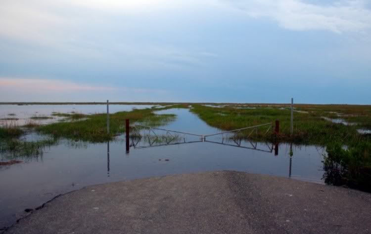
Back to the bay; below is a photo I took this spring on Thompson's Beach Road. With all the bay talk going on here, I figured I'd bring up the places that intrigue me most.

thompsonsml.jpg


Thompson's Beach along with Moore's Beach are two abandoned communities located south of the mouth of the Maurice River, quite near East Point. The latter I hiked out to, with Al, several full moons ago, and the walk there and Moore's Beach itself are magical. Many remnants of the old bay-side community are still there to be found. Reaching the beach merely requires strutting a potholed, abandoned road for a mile or so -- through a WMA at that -- there's great scenery along the way.

Thompson's Beach presents more of a challenge in accessing, as the picture above hints at showing. Thompson's Beach Road "now" officially ends at the gate, the portion beyond having been recaptured by the marsh; a wildlife preserve is now located at the place I took the photo (with plenty of spots to park a vehicle, plus there's an overlook stand here for viewing the area) -- the bay is two miles distant from this point. The bay-side town was abandoned several years ago and what one sees from (and beyond) the gate above is the now-flooded road that once accessed the town. Al and I have been talking for quite some time about tossing on the hip waders and working our way out to the bay. Utility poles can still be seen leaning in the distance, and I imagine much more in the way of structure remains of Thompson's Beach as well, as that community existed much more recently than did the one at Moore's Beach. Seriously, it whispers, "explore me."

DBX, anyone? :)

Bill
 

Teegate

Administrator
Site Administrator
Sep 17, 2002
25,938
8,679
Looks like an interesting place to explore. Maybe PBX will go there soon???

Do you travel to Reeds Beach which is just south of Moore’s Beach? To be truthful I was conceived there when my parents stayed in one of the small houses on the north road while helping my grandparents fix up their house that had been damaged by Hurricane Hazel 2 years before. I spent some time there during the 1960’s and even have a few photo’s. Here is one showing the Dickerson’s store where we would go to buy our food and soda. The steel structure behind the store was the boat rigging where my uncle would store his boat and enter and exit the bay. The store was picked up and turned so the front faces the road and it now is a much more modern structure. My uncle inherited the house and eventually sold it, and the new owners expanded it quite a bit. The residents of Reeds Beach are living on borrowed time, and one day another hurricane will come and devastate it as I witnessed during the semi minor storms of the 1960’s.

Reeds_Beach_Store.jpg


Guy
 
Top