Swimming in clay/sand mines...

manumuskin

Piney
Jul 20, 2003
8,552
2,465
59
millville nj
www.youtube.com
So I explored 4 blue holes today. One is my favorite in all of the state. Truly gorgeous initials are L.A. I don't want anyone to know where it is or get spoiled because right now its untouched and gorgeous. Members on the forum message me if you want to know. I dont want it getting out. The other 3 were cool. Looked around Menantico saw the ponds pretty and also found some ruins which were pretty neat. Did finally locate the large pond at Manumuskin which is gorgeous. The smaller pond is a nightmare. There are bottles of beer and old coolers left behind just everywhere it is horrid and makes me EXTREMELY angry.

Did also find ruins at Manumuskin but wasn't Fries Mill that I was looking for. If anyone knows how to get there (I trekked miles by myself today and couldnt locate what I was looking for) Please private message me. I don't want idiots to find the location if you are willing to offer some advice. Thanks Again! I will post pictures. The one lake is stunning.

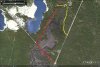
I have to go to work now but will send you a map of fries mill tomorrow complete with two routes into it.one is much shorter but the trails are almost gone.I also have some nice blue holes locations I can send you.Do you understand coordinates?You read maps well right?
 

manumuskin

Piney
Jul 20, 2003
8,552
2,465
59
millville nj
www.youtube.com
also the ruins you may have found at menantico could have been the ruins of clarks grist mill owners house if it was a nice rock lined cellar hole.There are many ruins back there including a furnace at cumberlan,a forge and much more.fries mills has many very nice cellar holes and several large rock chimneys.
 

pineywoman

Explorer
Aug 24, 2012
427
48
I am great at reading maps. In terms of coordinates, I am learning. However, the only gps unit I have is in my vehicle. In fact,had to google earth today when I was in Manumuskin. I was at that 4 way interesection sort of paved area and trekked around and took 3 of the 4 routes. Then I was able to locate the large pond by the google earth map. Normally, it is a lets just explore and check it out. I saw a ton of wildlife today. I did venture off into the woods in certain areas and saw ruins, definitely one looked like a cellar hole. Weird foundations of other things, but not homes. Probably a trestle at one time? I also saw old sewage piping and piping in general jetting out from the dirt into oblivion. It is fun and scary to venture alone. Most likely going with another person on next adventures. I trekked a lot. Even at menantico, weird ruins near the tracks there, sort of bunkerish. I'll post the photos up in the next few days so guys can check it out.

Any info would be appreciated and does not ever go into anyone's hands FYI. I just want to see it as it's probably the lesser explored ruins in our area and I like exploring. You got to check out LA. If you haven't, I think that's my favorite blue hole yet. Out of all of them.

I do understand coordinates and usually will just create a map of coordinates prior to a journey if needed. I found buttermilk falls that way in the Delaware gap since it is what they use to find it. However, the coordinates were for Pennsylvania side and the falls are in NJ. Haha. That one was fun, but found it. I'm a map nut. It's how I find my locations. I found sea breeze by looking at google earth without even knowing what it was or was all about and just wanted to go by what I saw, lol.

Thanks Manumuskin. Also, sucks you have to go to work now. 3rd shift on a Saturday night :(
 

manumuskin

Piney
Jul 20, 2003
8,552
2,465
59
millville nj
www.youtube.com
Okay a quick explanation.The red trail is longer but easier to follow.The yellow trail is shorter but the trail from the blacktop road to the bridge over the creek is a very old road with some trees across it.Purple square is an old chimney Blue square is two old chimneys and the remains of Potters/Fries Mill tavern.This cabin stood into the 90's and then punks burnt it down.I was in it back in the early 70's and a piano was still in it and I took a readers digest from it that was from 1945 and in excellent condition.
The Black square is fries Mills proper (read the interpretive map there and you will find some really nice ruins including the grist mill.Green square is where yours truly learned to swim as a 7 year old back in 71.The white square is the old chapel wher in playing with Daddy longleggers during service.The lavendar squares are gay bars,excuse me those are the platforms that were the floors of the pavilions we slept overnight in.They are concrete pads and so covered with pine needles and dirt they are very hard to find.The apache pad is closest to the trail,That was my hooch,then comanche and then blackfeet,each were for progressively older kids.The clearing you see there is the old ball field.The pink square is the NC caretaker house.He is an ex cop that never lost the attitude.He may be nice to you but he is a cocky prick to men.You are allowed out there just stay away from his house..The bridge is at the north end of my swimmin hole.
By the way where is this LA you speak of?I have probably been to every blue hole in cumberland county but not every hole in south jersey by a long shot.I don't fool around holes that are still being used though.
 

Attachments

  • Fries Mill.jpg
    Fries Mill.jpg
    237.8 KB · Views: 1,234

Spung-Man

Explorer
Jan 5, 2009
976
656
64
Richland, NJ
loki.stockton.edu
Don't forget about the Hartman maps:


Fries Mill is located on Map No. 3. It is also on a lesser known 1950 map drawn up by Hartman (excerpt below).

Fries Mill 2.jpg

Compiled by Chas. S. Hartman of Port Elizabeth N.J. 1950.
Byerly & Dorchester surveys recorded Burlington, N.J. Lib. M. Folio 15.
Survey made Apr, May & June 1691

My copy of the 1950 map is of poor quality, or else I would have uploaded the whole document. The series is a wonderful resource for all who wish to explore the poorly documented region of eastern Cumberland, western Atlantic, and northern Cumberland Counties. I had permission to copy the entire Hartman collection through the Atlantic County library, but the ball was dropped. Full-sized Hartman maps are available upstairs in the Mays Landing Library Branch in their own dedicated holder. I hope to resurrect the project at Richard Stockton College as part of the William Leap Collection, which members of the West Jersey Historical Round Table including myself helped establish.


S-M
 

pineywoman

Explorer
Aug 24, 2012
427
48
Manumuskin, you rock!! Thank you. I did venture straight down the red area, but didn't go out to Port Elizabeth. I did also go up a bit on the left portion of the red trail coming from in between the two ponds (that you didn't map off). I downloaded some of the pictures and am on my desktop now. So I will upload them now to here. THANK YOU so very much. I plan to check it out the next free time I can get!
 

pineywoman

Explorer
Aug 24, 2012
427
48
Touche Ben. Smartphone here as well (of course use to work in IT industry and would be lost if I didn't have one). I plan on buying a handheld unit.. They are uber cheap anymore these days. The map he laid out is great. I've actually already saved it to a word document and printed it out. From the written map, it looks like I spanned a lot yesterday and am kind of shocked by it. I pretty much toured almost 50% of it, maybe more. This place is absolutely huge. 3500 acres I believe.

Here's the small pond there.
http://gallery.njpinebarrens.com/showphoto.php/photo/15228/title/small-pond/cat/500

The large pond:

http://gallery.njpinebarrens.com/showphoto.php/photo/15229/title/large-pond/cat/500

As you can see in the large pond the storm was starting to come in. I had just gotten out of there in the knick of time. It was almost black by the time I got back to the car with a torrential downpour.

Oh and the lovely trash EVERYWHERE. Horrible. It is all down the path via Schooner Landing. Once you get past the small pond no trash though, but it was sooooo very very sad. To see it scattered everywhere.
http://gallery.njpinebarrens.com/showphoto.php/photo/15230/title/lovely-trash/cat/500
 

pineywoman

Explorer
Aug 24, 2012
427
48
Okay, Garmin got ya! Will put that on my list to pick up. Everyone has their own niche on here. Pretty cool. Boyd with the custom maps with GPS. Muskin with his piney adventures in crazy storms. hahaha
 

manumuskin

Piney
Jul 20, 2003
8,552
2,465
59
millville nj
www.youtube.com
  • Like
Reactions: pineywoman

pineywoman

Explorer
Aug 24, 2012
427
48
Even the Menantico?? That looked sort of bunkerish to me. Hmmm, interesting. I knew it wasn't a house or Fries Mills that was a definite. It is odd to see the trees growing out of the old asphalt roadways. Really odd, but not creepy odd. I don't get scared back there. It is actually quite peaceful. Audrey isnt really a secret (although it is to folks my way, FYI) I enjoyed how well-kept it is. It is a beauty. A few more I will be checking out. Menantico is funny because the one side looks like it was naturally placed there. Then you have the other which is like a blue hole. That is trashed too. (Menantico)
 

manumuskin

Piney
Jul 20, 2003
8,552
2,465
59
millville nj
www.youtube.com
The one side of the road is a landlocked Blue hole that is the result of rain water and ground water filling the hole dug by a mining operation.The other side of the road that looks more natural is also a sand mine but it is darker and richer because the menantico creek flows through it and fushed nutrients and life into it.You will notice the closer to the creek the blacker the water gets mainly because of more mud on bottom since Menantico is really a clear water stream.Further away from the creek toward the boat ramp the water is clearer with a sandy bottom and pondweed growing in it.In time this will accumulate mud and make the water look dark here also.The Sand wash I believe to be about 80 years old so it does take some time for a sterile sand wash to turn into a paradise of sorts.The place would be a paradise if trash didn't trash it.
 

pineywoman

Explorer
Aug 24, 2012
427
48
It's an interesting place. Can't wait to check more out and enjoy this year and next year!! I love my Pineys!

The water at the ramp is nice. I could see fish even in that one. A lot of like seaweed looking stuff on the river floor.

Thanks Muskin! You are THE Man!
 

Boyd

Administrator
Staff member
Site Administrator
Jul 31, 2004
9,505
2,766
Ben's Branch, Stephen Creek
Yeah, one of the cheaper Garmin units would be a good choice. One of our forum members, Boyd, has made some custom Pine Barrens related maps for Garmin GPS's.

My maps are available for free download here: http://www.gpsfiledepot.com/maps/byuser/282/

For general use, I would suggest the NJ 2012 map which is compatible with all Garmin mapping GPS devices. It contains a lot of detail not found on any other maps, including landcover (green areas are forest), State Forest trails, sand roads traced from aerial photos and Guy's pine barrens points of interest: http://www.gpsfiledepot.com/maps/view/294/

Even if you don't have a GPS, you can still use and print these maps on your computer. Download/install Garmin Basecamp before the maps though - it is free and runs of both Mac and Windows: http://www8.garmin.com/support/mappingsw.jsp

Many of my other maps (ones that contain aerial photos or scanned USGS maps) require a newer Garmin model. Here are a few models to consider. You need to shop around to find whatever is on sale to get the best deal. These are very different, so if you aren't familiar it would be worthwhile to visit a store like REI where you can see them in person: https://buy.garmin.com/shop/compare...349&compareProduct=63801&compareProduct=87774

BTW - nice photos! I need to explore that area myself one of these days. Also, if you are interested in ruins then you really need to check out Bethlehem Loading Company (Belco) at the Atlantic County park at Estell Manor. There are some spectacular ruins there. Many can be seen from the trails (which are on my map) but the real gems are buried deep in the woods where very few people have gone.

http://www.aclink.org/PARKS/mainpages/estell.asp

http://www.aclink.org/PARKS/mainpages/historic.asp
 
Top