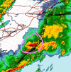
Rain is starting here. The weird thing is, the stong wind suddenly stopped when the rain started, now it's just light rain and light wind.
The alert ends at 6:00 PM, so hoping the worst is over, it was really intense for awhile here.
URGENT - WEATHER MESSAGE
National Weather Service Mount Holly NJ
205 PM EST Wed Mar 5 2025
Ocean-Cumberland-Atlantic-Cape May-Atlantic Coastal Cape May-
Coastal Atlantic-Coastal Ocean-Southeastern Burlington-
Including the cities of Long Beach Island, Atlantic City,
Millville, Hammonton, Wharton State Forest, Cape May Court House,
Ocean City, and Jackson
205 PM EST Wed Mar 5 2025
...WIND ADVISORY REMAINS IN EFFECT UNTIL 6 PM EST THIS EVENING...
* WHAT...South winds 20 to 30 mph with gusts up to 50 mph expected.
* WHERE...Atlantic, Atlantic Coastal Cape May, Cape May, Coastal
Atlantic, Coastal Ocean, Cumberland, Ocean, and Southeastern
Burlington Counties.
* WHEN...Until 6 PM EST this evening.
* IMPACTS...Gusty winds will blow around unsecured objects. Tree
limbs could be blown down and a few power outages may result.
PRECAUTIONARY/PREPAREDNESS ACTIONS...
Winds this strong can make driving difficult, especially for high
profile vehicles. Use extra caution.
")