Where we went?By the way, WJHE, it is amazing what does survive the passage of time. I could take you to see the location of a sawmill that ceased operations in 1726 in the Haddonfield-Cherry Hill area and a segment of the dam remains extant, along with a scour bowl in the embankment behind the dam caused by the dam being breached by a large freshet after operations ceased. It is an amazing sight and site in 21st-century suburban Camden County!
Best regards,
Jerseyman

What to look for when trying to find an old watermill site
- Thread starter WestJerseyHistoryExplorer
- Start date
You are using an out of date browser. It may not display this or other websites correctly.
You should upgrade or use an alternative browser.
You should upgrade or use an alternative browser.
Wow! Virtually 15 years ago! That's amazing. I guess you could say there's been a lot of water go over the dam since then!
I miss those days of conducting fieldwork. When the virus is over, we need to plan another group activity!
Best regards,
Jerseyman
I miss those days of conducting fieldwork. When the virus is over, we need to plan another group activity!
Best regards,
Jerseyman
Last edited:

It's nice to see you're still coming here!Wow! Virtually 15 years ago! That's amazing. I guess you could say there's been a lot of water go over the dam since then!
I miss those days of conducting fieldwork. When the virus is over, we need to plan another group activity!
Best regards,
Jerseyman
")
Thank you for the greeting, Ben; it means a great deal to me!! It has clearly been too long, but I was not sure how the regular folks here would feel about my return after such an extended hiatus. I can see I have missed some great threads and postings and I will respond to a few of them as time permits.
It is great to see many of the same folks still pursuing their individual interests in the Pines. Of course, history will be my personal pursuit until the day they shovel dirt in my face!
Best regards,
Jerseyman
It is great to see many of the same folks still pursuing their individual interests in the Pines. Of course, history will be my personal pursuit until the day they shovel dirt in my face!
Best regards,
Jerseyman
I was not sure how the regular folks here would feel about my return after such an extended hiatus.
It's never too late to come home. Great to have you back!!!
The good news is that NJ just released high resolution imagery for all of Southern NJ within the past couple weeks. But the bad news is that I won't have time to make any maps from it for awhile.
Just to update this thread.... a new map is now available with 1-meter LIDAR for everything South of I-195. This map just shows the terrain, I will be releasing another map with roads, waterbodies, etc. in the future. Here's an example using the raceway link that @pinelandpaddler posted above. As you can see, there's quite a difference.
https://boydsmaps.com/#17/39.83589/-75.05702/lidar2021bw/0.00/0.00
Last edited:
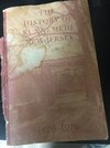
Thank you all for the time you have taken to help me out and lend me some much needed input. Ive had two deaths recently in the family and within a week from each other so its hard to find the motivation to get back into things im into. If anyone is interested in meeting up at the tavern and exploring the area around it feel free to shoot me a message through text or on here . I have a metal detector i can also bring with me to search the area behind the tavern . I wouldn’t dare dig anything there or anywhere without permission. What i would like to use the metal detector for is to locate big concentrations of iron in the ground. I hope that big patches of iron in the ground could be the nails of a burnt or collapsed structure. Im aware of the huge “ no metal detecting “ sign but thought that usually pertains to digging up and damaging the property. I could find potential sites of a home / mill etc. just by swinging the metal detector over the ground and locating these patches of iron. Does anyone know if that would be frowned upon? My guess is yes just because if someone sees me with a metal detector back there , they might get the same idea and potentially cause damage . Hope to hear from anyone who is interested. Until then ill be reading a book given to me by my neighbor. ( attached photo )
Tim
856 393 5541 ( text me )
Tim
856 393 5541 ( text me )
Attachments
West Jersey History Explorer:
Your search for the sawmill has sparked my interest. During your fieldwork, you should concentrate your investigation on the mouth of Otter Branch, because a 1724 court order for clarifying the boundary between Gloucester and Newton townships refers to this stream as "Samuel Ward's Mill Creek." In January 1717, the New Jersey Colonial Assembly passed an act to raise revenue through taxation. This is the only early tax act found that lists individual sawmills and gristmills by county and Samuel Ward's name is not enumerated within the law, suggesting that Ward established his mill sometime between 1717 and 1724. It is likely that Ward located his mill at or proximate to the mouth of Otter Branch since the topography of the land leading to the mouth is a rather deep ravine—ideal for creating a millpond. Since Ward's 1729 will fails to mention the sawmill in its covenants or the associated inventory (stock of lumber), Ward likely had ceased milling operations there prior to his death. Perhaps a freshet wiped out the dam.
In 1756, Gabriel Davis constructed his tavern at the top of the bluff overlooking the North Branch of Big Timber Creek. To facilitate access to the tavern and the landing, Davis constructed the floodgates dam. Since he built the dam just above the head of tide, Davis's project did not require a legislative act. The floodgates dam prevented the flow of water up the branch beyond the dam, thereby allowing the farmers along the waterway to maintain their meadows. The dam included a gated sluice bypass that allowed for repairing the dam. Some documents mention "sheeting" adjacent to the dam. This installation of timber prevented the creek bottom from being scoured. The detail below from the 1777 road map shows both the dam and the sluiceway:
View attachment 14550
The sluiceway at the dam should not be construed as a millrace, so the location previously identified in this thread is incorrect.
The next potential sawmill to occupy the mouth of Otter Branch belonged to Nicholson & Troth, 1816-1818, although it is unclear whether it ever actually operated. Rather than repeat what Bill Farr wrote about the mill, I will direct all readers here: http://www.westjerseyhistory.org/books/farrwatermills/N.shtml
Some judicious digging might reveal remains of the dam and/or the mill foundation, but the construction of the Floodgates Road Bridge (now a ruin) over the mouth of Otter Branch and the widening of Somerdale Road might have destroyed the evidence of the dams and mills.
Best regards,
Jerseyman
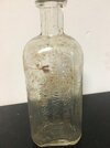
Jerseyman, thank you for the much needed input ! I kept coming across posts which would have “ Jerseyman is the one you need to talk to about this .” Today i am going to take a walk back there and follow up on everything you have suggested to check out. I will post an update later along with photos. Anyone who wants to join me or search on their own can simply park at the tavern . The front of the tavern ( front faces Timber creek ) has newly built steps leading down to a trail that you can follow right up to the creek. Once at the bottom of the steps also keep your eye to the ground on your left . To me it looks like a spring that may have had a springhouse constructed over it due to numerous large pieces of field stone arranged in what looks like an old foundation. There is also a large recently felled tree youll see and in that trees’s rootball i found an old corktop medicine bottle . So keep an eye out !
Attachments
So good to see you post again, Jerseyman! Great info as always. Evidently, the mill dam was not in the same location as the old Floodgates Road Bridge. There does appear on Lidar what looks to be an old road or possibly a dam just a short distance upstream from the old bridge: https://boydsmaps.com/#18/39.83768/-75.05812/lidarHD
I hope to get out there soon to do some ground-truthing. My curiosity has been piqued.
Welp, what appeared to be something on the older lidar does not show up on the new lidar. I'm looking here for the location of the dam:
Last edited by a moderator:
I think the old, lower-resolution LIDAR encouraged people to see things that weren't really there. This is especially true of my old map that is now on NJPB Maps. 
The feature certainly appears on the lidar image; it just wasn't an actual feature on the ground. I wonder why.I think the old, lower-resolution LIDAR encouraged people to see things that weren't really there. This is especially true of my old map that is now on NJPB Maps.
OK, I think I finally have an answer for you.Would the mill have been on the bee lane side of Somerdale road ?
Dam: https://boydsmaps.com/#18/39.83730/-75.05852/lidar2021bw
Race: https://boydsmaps.com/#18/39.83759/-75.05900/lidar2021bw
Mill: https://boydsmaps.com/#18/39.83763/-75.05943/lidar2021bw
Last edited by a moderator:
Gabe, whenever this rain ends i will go to the coordinates of each feature above and take photos. Again , thanks so much for the help.
on a related note, i also remember an old foundation upstream where Otter Branch crosses Evesham. I remember playing around it as a kid and the old barber Bubbico in Magnolia would talk about it
It was right around this area https://boydsmaps.com/#17/39.84904/-75.05207/lidar2021bw
It was right around this area https://boydsmaps.com/#17/39.84904/-75.05207/lidar2021bw
Last edited by a moderator:
I made it out to where I thought the mill site might be. I left disappointed. The area is thick with briars and I wasn't able to get a good look. I saw no evidence of a dam or race, but I can't claim to have done an exhaustive search.