Oh man. I tried to dig one up for my collection. I gave up real quick, it's like steel cables all knotted together. I ended up taking the inflorescence and a small part of the stem with one leaf.I think some ground-truthing is in order!
Where is this?
- Thread starter Teegate
- Start date
You are using an out of date browser. It may not display this or other websites correctly.
You should upgrade or use an alternative browser.
You should upgrade or use an alternative browser.
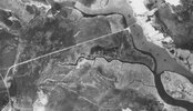
@Boyd Thoughts on John’s hypothesis ?When I was thinking it could be phragmites I never realized they grew in circular clusters. Is the ground actually pushed up or is the base of the plants so dense that the LiDAR sees it as ground. I’d imagine the root system would be more dense around the edges simply because there’s more nutrients there. They could be so thick that they are choking themselves out in the center.
If the elevation differences between the rims are anywhere close to being accurate, we should be able to tell just by walking aroundOh man. I tried to dig one up for my collection. I gave up real quick, it's like steel cables all knotted together. I ended up taking the inflorescence and a small part of the stem with one leaf.
I can split this part out into a separate thread if you like, but which post should it start with?
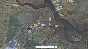
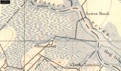
Prior to Lower Bank Road being built, when you left LB by crossing the bridge out of town the road turned left through the meadows and towards Landing Creek. When you reached Landing Creek you could turn left and go towards the "warf" at the mouth of the creek & Mullica River. Two years ago the bulkheads along the creek were still visible at low tides, but rotting pretty well. If you reached landing creek and turned right you went towards San Francisco Ave. There are small wooden stuctures that are likely bridge supports. They too can still be seen. San Francisco Ave (Gloucester Landing) was the port of entry from the Mullica River waters to Egg Harbor City. As you pass under Clarks Landing Rd, continuing south, you will come to the old location of Gloucester Furnace. It was a town with sawmill (Guy, Gabe, Bob, myself have seen the sawmill base). Mark S. and I paddled & explored the whole creek for days one summer. It's beautiful. There was once a furnace and town at this location which was owned by the Richards Family of Batsto. On the 1930 map note that Clarks Landing Rd is simply a dirt road and does not follow all the way through to Philadelphia Ave (Rt 563). I know that structure you are speaking of and knowing the history there, I've assumed it's an old dock or loading area for product that was once produced at the furnace and/or for lumber harvested to be shipped down creek to the river warf. That's what i know of that area and I hope it's helpful.I can see that it was built sometime between 1931 and 1942. Do you have more specific information?
Attachments
That would be incorrect Ron.My only guess is, that it is at Wells Mills Park.
Tuckerton Seaport?Seen yesterday. I've not noticed it before, but then it has been placed about 7 feet off the ground.
View attachment 20308
When I posted it, I figured it would be unfair to do so because it could be anywhere along that road. So I will give a huge, one word clue: SkirmishTuckerton Seaport?
No, that is incorrect.Not on shore rd, but Osborn Island?