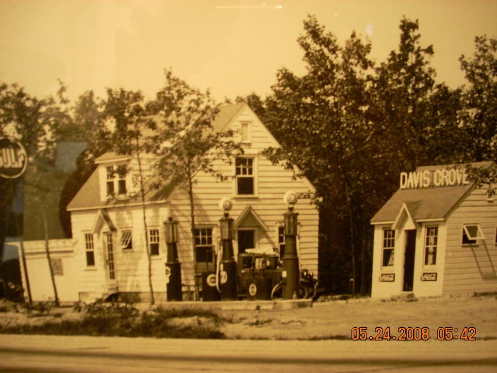
Where was Davis Grove?

Okay, Folks. I was in Mount Holly today, so I copied the Route 40 drawing and the deed for the property. The survey stations shown on the plan I posted in a previous message are 100 feet apart as the scale on the original drawing is 1"=50' and those station lines are 2" from one another. The diagonal road appears to be a shortcut route to get to the main Burrs Mill-Bozarthtown Road that remains in place today.

To quote the deed (Book 802, p. 454) in setting the beginning point on the southeastern boundary marker on the property known as tract no. 2: “BEGINNING at a point in the last course of the tract or land described as tract number three (3) in the deed of conveyance Haines to Kennedy; said point being nine hundred sixty four and eight tenths feet eastwardly from the beginning corner located in the centre of what is known as Bozarthtown and Burrs Mill Road…”

So, if you want an exact location for the Davis Grove filling station, the westernmost monument should be found at 798.49' from the center of the present Burrs Mill Road.

Best regards,
Jerseyman

P.S. Doug—if you want the drawing and deed copies for your files, just drop me an email with your snail-mail location. Your wife has my email address.
 

oji

Piney
Jan 25, 2008
2,129
549
64
Browns Mills
Would that make it in the triangle bordered by Beebe Lane and Rt.70? BTW What are the odds the fuel tanks are still in the ground? Oops looks like Guy beat me to the draw. Is he as quick with a sixgun:)
 

Teegate

Administrator
Site Administrator
Sep 17, 2002
26,008
8,774
Would that make it in the triangle bordered by Beebe Lane and Rt.70? BTW What are the odds the fuel tanks are still in the ground?

I would say you are correct. As for the tanks, I bet the state would be surprised if they were.

Guy
 
So that put the western corner of the property here. It appears Beebe Road goes through it maybe.

http://maps.google.com/maps?q=39.888774,-74.654665&ie=UTF8&t=h&z=16&iwloc=addr


I went down the middle of 70 and not on the property. I will get there in a few weeks and look for it if nobody else does.

Guy

Guy:

Tract no. 2 featured 5 sides, all located east of Beebe Road with the northwestern side running along the edge of Beebe Road:

Detail_from_6_of_10_2937.jpg


This is from a different drawing of Route 40. Let me know if you have any questions.

Best regards,
Jerseyman
 
A

anghew025

Guest
OK...OK...OK... I think I got it now. I'm sorry, I'm an auto mechanic. Looking at enginnering maps and blueprints make my head feel funny.:) Jerseymans post from Monday after he got back from Mount Holly threw me off at first, but after really reading that one a few times, and then TeeGates and oji's, then seeing Jerseymans 2nd drawing, I now see where it is. I guess when I was out there Saturday, I was in the right church, but in the wrong pew. I was about 1000 feet east of the actual spot. But couple things still throws me off, though. First, on the drawing and the blueprint, there is, what seems to me I guess, a road that acts as the south side of Bebee Lane. Was that really there? If so, is it still? I cant see it on the Google overhead maps of today. Or is it a misinterpretation of Burrs Mill rd.? Secondly, how come you cant see any images of any buildings on the 1930 fly over pictures? Again, this is all new to me. You guys are the pros. I defer to you. And now, the $64,000 is, what happened to the buildings? And, I'm with you oji, I too would love to know if those tanks are still there.

To TeeGate- When are you planning to head out there? Maybe we could meet up, if the schedules match. Let me know.

To Jerseyman- I would GREATLY appriciate copies of the deed and drawings, and, if you have the possibility to, could you get a copy of the second drawing you posted too? It would be great to have them on hand when i take my pop out there with me. I will have the Mrs. drop you a line with our locale.

Thanks again everyone, this as been a whole hell of alot of fun. I honestly cant wait for the next one to pop up on this forum!!!

Douglas M. Cranmer


Doug:

Not a problem feeling funny when presented with blueprints and engineering drawings—been there, done that!! Sorry my posting yesterday confused you. I cannot say absolutely that the shortcut road to Burrs Mill Road that is now Beebe Road on the north side of Route 70 ever extended across the highway, although I suspect that it did at one time. However, if the Burlington County Clerk’s office ever recorded this road in a road return, such a document made the roadway a legal right-of-way and the state would have a record of it on its drawings.

I agree with you—I also do not see the buildings on the 1931 aerial photo either. I have calculated that the contract for the aerials was carried out during late 1930 and into about April to June 1931. We know that Davis did not acquire Lot no. 2 until 1932 and I am almost certain he constructed the dwelling house. I postulated before that the small building and pumps may have predated the house, but my musings are not necessarily correct and, based on the aerial, I would say I was wrong.

As to when the buildings came down, I guess you could check that out on historicaerials.com, which has coverage for this area beginning in 1954 or 56. Perhaps checking the weekly Medford Central Record newspaper might help answer that question, although it would be like looking for the a needle in a haystack unless you can narrow the search dates down.

Yes, I think all of us have enjoyed this pursuit!! Do have any other mysteries in your family????

Best regards,
Jerseyman
 
Doug:

I just noticed on the Route 40 drawings that the roadway crossing on an angle adjacent to the Davis Grove filling station is labeled as 49.5 feet wide. This measurement makes the thoroughfare a 3-rod road, suggesting it dates to the eighteenth or early nineteenth century. I am now almost certain that a road return does exist for it in one of the road books in the Burlington County Clerk’s Office. All of the road books are kept in the basement record room on the opposite from the deed grantor-grantee indices. If I have an opportunity, I will look, but I am not certain when that will be.

Best regards,
Jerseyman
 

bobpbx

Piney
Staff member
Oct 25, 2002
14,721
4,908
Pines; Bamber area
Guy:

Tract no. 2 featured 5 sides, all located east of Beebe Road with the northwestern side running along the edge of Beebe Road:

Detail_from_6_of_10_2937.jpg


This is from a different drawing of Route 40. Let me know if you have any questions.

Best regards,
Jerseyman

Jerseyman, do I see the word "pumps" on the little oval on the property by the roadside?
 
Jerseyman, do I see the word "pumps" on the little oval on the property by the roadside?

Indeed you do, Bob! The word “pumps” designates that the oval—or pump island—sported the gasoline dispensing pumps. At the time this drawing was made, two pumps stood on the island. I believe the original photo that LMCFashions posted showed three pumps there.

Best regards,
Jerseyman
 

oji

Piney
Jan 25, 2008
2,129
549
64
Browns Mills
Guy, If you're not spot on, then I believe you're darn close. Take a look at the USGS Pemberton Quad http://gallery.njpinebarrens.com/showphoto.php/photo/5284 and focus on the road coming from the Ongs Hat area, around what I think are the clearings to the north and then to Burrs Mill.

I think jmaul has something here, the 1885 topo shows roads east of Burrs Mill Rd. that continue on to Burrs Mill. On my 1958 topo these roads stop at Rt.70. Yesterday I visited the area and walked aroundfrom the road just east of Beebe Ln. to a short distance from Burrs Mill Rd. and saw no signs of a gas station. I even looked in the woods near Fire Ln. thinking that if they repaired cars they might have thrown old parts in the woods behind the station. I did see some small dirt mounds in the woods by Beebe Ln.
 
Guy, If you're not spot on, then I believe you're darn close. Take a look at the USGS Pemberton Quad http://gallery.njpinebarrens.com/showphoto.php/photo/5284 and focus on the road coming from the Ongs Hat area, around what I think are the clearings to the north and then to Burrs Mill.

I think jmaul has something here, the 1885 topo shows roads east of Burrs Mill Rd. that continue on to Burrs Mill. On my 1958 topo these roads stop at Rt.70. Yesterday I visited the area and walked aroundfrom the road just east of Beebe Ln. to a short distance from Burrs Mill Rd. and saw no signs of a gas station. I even looked in the woods near Fire Ln. thinking that if they repaired cars they might have thrown old parts in the woods behind the station. I did see some small dirt mounds in the woods by Beebe Ln.[/QUOTE]

oji:

I am not certain what you are saying here, but the deed for the property, in combination with the second map I posted, clearly defines the location of the property with a precise measurement from the center of present-day Burrs Mill Road.

Whether anything remains at the site today or not, the site for the former Davis Grove filling station is definitely identified and located!

Best regards,
Jerseyman
 

oji

Piney
Jan 25, 2008
2,129
549
64
Browns Mills
I have no question that it was there. I was just saying that everything was cleaned out after the demolition. I was also wondering that the current Rt. 70 might be wider than the original Rt.40 making the roadway closer to where the pumps were located.
 
oji:

Thanks for your clarification. Yes, I think Route 70 is wider than the original Route 40 construction. In fact, if you take another look at the photograph that LMCFashion posted and then take a look at the blueprint and the second drawing I posted, you will see that the state planned to take most of the outer island of land containing a pole and a light. Sure enough, the photograph depicts that the pole and light as both gone. I think when the Rockafeller Foundation paid to have the road improved further, I suspect additional widening may have occurred. Furthermore, the Rockafeller money also paid for roadway beautification, so it could very well be that the filling station and house fell to the wreckers during the work the foundation funded. The Rockafeller money and its work was reminiscent of Ladybird Johnson’s efforts to rid American highways of its ubiquitous billboards during the 1960s.

Best regards,
Jerseyman
 

omega

Explorer
what an interesting thread, and it brought up memories. First the picture Guy posted, I drove by that old gas station nearly every week back in the 80's on my way too and from Glassboro State. I remember the widening of 70 and the sunoco station with a sign sayind "This is progress?" or something to that effect, and the vacuum repair shop... I had forgotten about that. and then the Scranton connection, My grandparents came there from Wales about 1905, and I worked in TV there in the mid to late 80's. And I can't leave out the mystery solving efforts of Jerseyman, incredible.

I know the next time I drive route 70 what I will be looking for. :lol:
 

Teegate

Administrator
Site Administrator
Sep 17, 2002
26,008
8,774
All,

It has taken me until yesterday to get to the location of Davis Grove and search around for evidence of it’s existence. Various other endeavors have prevented me from getting there. The evidence I was looking for are the monuments shown on the maps posted in this thread by Jerseyman. He was kind enough to pass along to me a larger view.

It actually is quite easy even after all these years to figure out the location using the maps, and starting at Burrs Mills Road I worked my way down 70 even going past the location of Davis Grove. In the end I was unable to find any evidence of the monuments. That is not to say they are not there since they more than likely would be below the surface of the ground. I suspect some of them if they survived would be under the asphalt that now lines the edges of the road.

I had parked in two place along the grass edges of 70 while exploring, and as usual for me I get consumed in what I am doing and don’t watch what goes on around me. My kids had at first searched with me, but retreated to the car with their iPods. And while I forged on with a blind eye to the world, the State Police were riding by keeping tabs on me. After driving across 70 and parking along Burrs Mills Road, he finally had enough and confronted me. It turns out I should have not parked there along the road.

He also was concerned on what I was doing, and a quick explanation by me using Jerseyman’s maps was all he needed to see. With a smile and a laugh he headed off to let me continue on. His laugh told me two things, either he understood completely what I was doing, or he thought I was crazy and let me go. I will keep my believes on which of the two I think it was to myself.


Jessica keeping tabs on me.


IMG_1213.JPG


In my opinion this is the same view shown in the Davis Grove Photo. Plus or minus a few feet. If we can believe the one tree leaning to the left between the two buildings is still in existence, it would be the larger tree on the left in this photo. Maybe a stretch but one can only wish.


IMG_1223.JPG


davisgrove.jpg


I will return later this year and look again.

Guy
 

oji

Piney
Jan 25, 2008
2,129
549
64
Browns Mills
Guy, Where do you think it was located? My guess is the grassy clearing on the east side of Beebe Ln. Whoever demolished the place did an excellent job cleaning up the area.
 
Guy:

Good job on your attempted location of the former filling station known as Davis Grove. This thread may not go away anytime soon as a friend of mine has just received a query from a descendant of the Davis family from which the place takes its name. I could not believe it when he sent me an email inquiring about Davis Grove. I explained that I had just finished the research to locate the place and I gave my friend a link to this thread! It is amazing how small the world has become with the Internet!!

I will keep you all posted on the Davis connection.

Best regards,
Jerseyman
 

Teegate

Administrator
Site Administrator
Sep 17, 2002
26,008
8,774
Jerseyman,

That is interesting for sure. It is a small world. Looking forward to hearing the results.


Guy
 
Top