Winter Storm Watch

Boyd

Administrator
Staff member
Site Administrator
Jul 31, 2004
9,505
2,766
Ben's Branch, Stephen Creek
Here we go... although "uncertainty is very high"
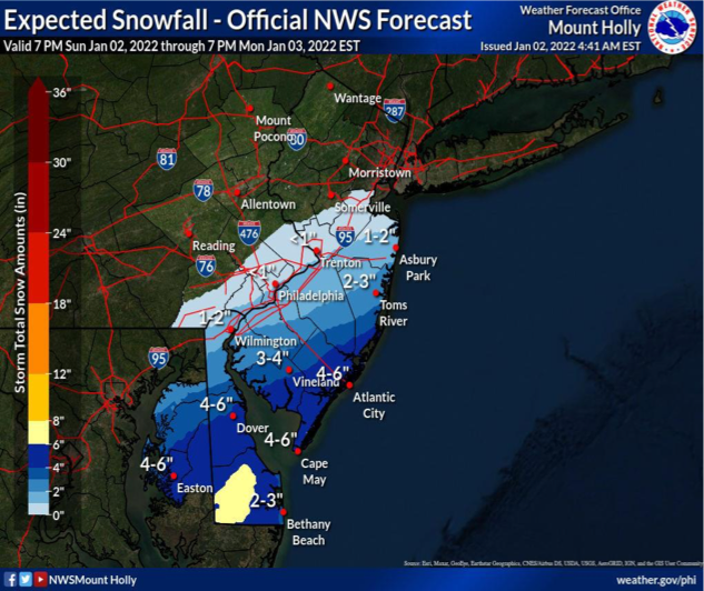
Screen Shot 2022-01-02 at 7.21.18 AM.png


Event Summary

A period of snow, which may begin as rain, is expected for southern portions of Delmarva and southern New Jersey through much of Monday.

Snowfall rates of 1 inch per hour or higher are possible in the heaviest snow on Monday morning. This could cause major impacts to the Monday morning commute. Roads could become snow-covered rapidly with these snowfall rates.

Uncertainty in this forecast is very high; this is the most uncertain 24 to 36 hour snowfall forecast in recent memory. Additional forecast changes, potentially significant, are likely.

Gale force winds are possible on some of the local coastal waters

Additional rounds of coastal flooding are expected, and the coastal flood threat for Monday morning has increased. A Coastal Flood Watch has been issued for tidal portions of Atlantic, Cape May, and Sussex Counties.


  • Love
Reactions: manumuskin

bobpbx

Piney
Staff member
Oct 25, 2002
14,153
4,258
Pines; Bamber area
Uncertainty in this forecast is very high; this is the most uncertain 24 to 36 hour snowfall forecast in recent memory. Additional forecast changes, potentially significant, are likely.

I see they are hedging their bets. I've never seen a statement like this from a weather service. I suppose it's the new normal so they aren't criticized. I could see this if it were 4 days away - but 24 hours away?
 

Boyd

Administrator
Staff member
Site Administrator
Jul 31, 2004
9,505
2,766
Ben's Branch, Stephen Creek
I'd say they're just telling the truth. This is what their current projection is, but they could be wrong. So it's up to you to decide whether to believe it or not.
 
  • Haha
Reactions: bobpbx

1Jerseydevil

Explorer
Feb 14, 2009
567
214
I'd say they're just telling the truth. This is what their current projection is, but they could be wrong. So it's up to you to decide whether to believe it or not.
In other words, nothing new here, look out the window as always.
 
  • Haha
Reactions: Boyd

enormiss

Explorer
Aug 18, 2015
574
366
Atco NJ
Hard to believe as warm as it's been that anything would accumulate.
Alarm goes off 4:40 tomorrow and I'll look out window :)
 

imkms

Explorer
Feb 18, 2008
587
224
SJ and SW FL
A snippet from the NWS at 4:40pm today

“Snowfall totals: By daybreak, there will be less than an inch of
snow across much of southern New Jersey and the Delaware Valley. But
snow ramps up during the morning commute, and by the afternoon,
there is an expected total of 5-7 inches across southeast New Jersey
and Delmarva, a swath of 2-4 inches from about central New Jersey
down the I-95 corridor, including Philadelphia and Wilmington,
although it looks like Philadelphia will be on the lower side of
that. Less than an inch elsewhere, with no snow expected for the
southern Poconos, much of the Lehigh Valley, and far northwest New
Jersey.”
 

Boyd

Administrator
Staff member
Site Administrator
Jul 31, 2004
9,505
2,766
Ben's Branch, Stephen Creek
Oh great, I am in the maximum snow zone, 6 to 8 inches. :siren:

Screen Shot 2022-01-02 at 6.36.30 PM.png


Event Summary

A cold front will lead to a rapid drop in temperatures through tonight. Rain will move into the region from the southwest after midnight, transitioning to snow in the early morning hours.

Snowfall rates in excess of 1 inch per hour are possible in the heaviest snow on Monday morning. This will likely cause major impacts to the Monday morning commute. Even though roads may initially remain above freezing, higher snowfall rates will still lead to roads eventually becoming snow-covered in areas under warnings or advisories.

There remains some uncertainty in the forecast, particularly in how far northwest the snow will move inland. Locally higher snowfall totals above 8 inches cannot be entirely ruled out where heavier banding forms.

Gale force wind gusts are likely on the coastal waters and lower Delaware Bay with a Gale Warning in effect.

Additional rounds of coastal flooding are expected. A Coastal Flood Warning has been issued for tidal portions of Atlantic, Cape May, and Sussex Counties.
 

Boyd

Administrator
Staff member
Site Administrator
Jul 31, 2004
9,505
2,766
Ben's Branch, Stephen Creek
Quite a change in the predictions overnight, now there's a very large area of 8 to 12 inches and unfortunately they are more confident about it! To top it off, temperature will drop to 12 degrees tonight. :siren:

"Increased confidence for impactful snow across the southern half of the forecast area."


Screen Shot 2022-01-03 at 7.29.34 AM.png


Rain will be changing over to snow by sunrise. Snowfall rates around 2 inches inch per hour are possible in the heaviest snow band this morning. This will likely cause major impacts to the Monday morning commute. Even though roads may initially remain above freezing, higher snowfall rates will still lead to roads becoming snow-covered in areas under warnings or advisories.

There remains some uncertainty, primarily with the northwest extent of accumulating snow. The uncertainty is highest near and northwest of the I-95 corridor.

Storm force wind gusts are expected on the Delaware coastal waters. Gale force wind gusts are expected on the rest of the coastal waters and lower Delaware Bay with a Gale Warning in effect.

Coastal flooding is expected with this morning’s high tide and with the morning high tide on Tuesday. A Coastal Flood Warning has been issued for tidal portions of Atlantic, Cape May, and Sussex Counties.

Another round of wintry weather is possible Thursday night into Friday. If the threat for impacts with this storm increase, we may start briefings for it later this week.
 
Last edited:

bobpbx

Piney
Staff member
Oct 25, 2002
14,153
4,258
Pines; Bamber area
I've never seen a map like that Boyd. A swath of snow 8-12 inches deep, and maybe 12 miles wide right next to one 3-4 inches deep? I'll have to get up to speed to get over the shelf if I head north from Barnegat.
 
  • Like
Reactions: Boyd

Boyd

Administrator
Staff member
Site Administrator
Jul 31, 2004
9,505
2,766
Ben's Branch, Stephen Creek
A swath of snow 8-12 inches deep, and maybe 12 miles wide right next to one 3-4 inches deep?

I find that map really confusing and the labels are misleading. I believe the light yellow band you refer to is actually only 6 to 8 inches deep, and the large darker yellow-orange area represents the 8 to 12" snowfall. Look at the color code in the scale at the bottom left. The way I read the map, you, I and quite a large portion of the pines are going to get 8"-12", and that "shelf" is going to be only 6"-8". I suspect the 3"-4" label refers to only Atlantic City?

This is just quick and dirty, but I think the magenta area here is projected to get 8 to 12 inches. That's the way I read it anyway....

Screen Shot 2022-01-03 at 9.54.14 AM.png
 

Teegate

Administrator
Site Administrator
Sep 17, 2002
25,602
8,181
It is a sleeper up my way so far. Dusting at best.
 

Boyd

Administrator
Staff member
Site Administrator
Jul 31, 2004
9,505
2,766
Ben's Branch, Stephen Creek
I don't think that's what the NWS is forecasting. Just go here, click on any locations in the magenta zone of my little map and look at the forecast. They all show really heavy snow in the 7 to 12 inch range


Like I said, look at the legend on the bottom left. As the colors get darker, the amount of snow gets greater. Can't imagine that would be a "mistake". I think the 8"-12" label is just in the wrong place on the map. The 1"-3" zone is blue.

Screen Shot 2022-01-03 at 10.09.11 AM.png


But maybe I'm not understanding what you're saying? Anyway, in a few hours we'll know. I sure hope you are right, I'd much rather get 3 to 4 inches total - however, we already have that much down here!
 

bobpbx

Piney
Staff member
Oct 25, 2002
14,153
4,258
Pines; Bamber area
I don't think that's what the NWS is forecasting. Just go here, click on any locations in the magenta zone of my little map and look at the forecast. They all show really heavy snow in the 7 to 12 inch range


Like I said, look at the legend on the bottom left. As the colors get darker, the amount of snow gets greater. Can't imagine that would be a "mistake". I think the 8"-12" label is just in the wrong place on the map. The 1"-3" zone is blue.

View attachment 16552

But maybe I'm not understanding what you're saying? Anyway, in a few hours we'll know. I sure hope you are right, I'd much rather get 3 to 4 inches total - however, we already have that much down here!

We are in agreement. I was saying that for them to put 3-4" on the map (for our area) which you posted at 7:34 was the mistake.
 
  • Like
Reactions: Boyd

Boyd

Administrator
Staff member
Site Administrator
Jul 31, 2004
9,505
2,766
Ben's Branch, Stephen Creek
Here's a bigger version of the map that is more clear. The placement of those labels is still very confusing, but if you just use the color scale then it makes more sense.

Screen Shot 2022-01-03 at 10.24.33 AM.png
 
  • Like
Reactions: bobpbx

Boyd

Administrator
Staff member
Site Administrator
Jul 31, 2004
9,505
2,766
Ben's Branch, Stephen Creek
Same here, with a steady light snow falling at the moment. The storm warning ends in four hours, I'm wondering if another shoe is about to drop because at this rate I doubt that we'll make it to 12 inches. The heavier snow bands appear to be hugging the coast right now.
 
  • Like
Reactions: manumuskin
Top