Fall/Winter Stone Searching 2021/2022

Teegate

Administrator
Site Administrator
Sep 17, 2002
25,648
8,255
All,

Recently, a map was passed along to me and after looking it over I realized I had three stones to find, one incised with the letters JB. Looking the map over I was able to determine approximately where they would be located but it soon became apparent they were on private property. I then contacted the owner and was graciously granted permission to explore. At that point I started plotting them using all of the available info I had here or was able to acquire.

A little background. The stones are located in Bishop's swamp (sometimes called Vinicomb's pasture) on what one deed calls "Fast Land." I did not know what that really meant so I contacted Rednek and he sent me the definition. Fast Land is described as: land that is located immediately above the high water mark of a navigable body of water. It is obvious now to me that a navigable body of water can be considered anything that you could put something as small as a kayak in because the body of water near it is really small. And I have to believe that they call it Fast Land because while surveying across a swamp it is really slow until you get to the high ground. Just a guess.

Here is what the map says.

Fast Land.jpg


And here is how a 1909 deed describes the incised stone.


All the following hereinafter described tract of land, cedar swamp and premises situate, lying and being in the said township of Tabernacle, county and state aforesaid, and according to a survey made by Job Irick, Deputy Surveyor, 10 mo, 17th day A.D. 1829 in the presence of adjoining owners, is butted and bounded as follows. Beginning at a stone J.B. standing on a point of land and on the westerly side thereof, and on the the south side of a swamp, and runs....

deed1.jpg


As you can see the stone and the letters JB have been there since at least 1829 with JB most certainly Bishop's initials.


I spent a few evenings working on this and came up with the three possible locations the stones could be. Two of them were within 800 feet of each other but the third was much further. So I concentrated on the first two with the intent to return multiple times if needed to find all of them.

This morning Jessica and I headed out early and arrived to find hunters on state land nearby. Pretty certain they would not be a problem we headed into the woods toward Bishops swamp. The deed tells us the JB stone was not in the swamp and when arriving at the location this was true.

In less than 30 seconds I discovered the stone sticking up a foot from the ground. And on the side of it turned 90 degrees were the initials JB. Time has worn away the stone but the letters are there. Some other markings are below them but I have no idea what they are.

DSC_3689a.jpg


DSC_3693a.jpg


Letters JB

DSC_3690a.jpg


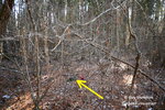
The arrow points to a yellow pin where I felt the stone may be. And the numbered points are from me getting GPS coordinates of the stone itself. They are about 4 feet away from my calculations.

pointer.jpg


The next stone was 800 feet away directly across Bishop's Swamp. And a swamp it was. There was a solid hard sheet of ice covered by a thin layer from last night freeze. Each step was a struggle and it was slow going.


Jessica texting in Bishop's swamp.

DSC_3699a.jpg


DSC_3703a.jpg


DSC_3702a.jpg


DSC_3700a.jpg


Unfortuanly, we were not able to find the second stone so very soon we will return. We then started our journey back a different route and the swamp was even worse. Jessica fell fully in twice and flooded her boots, her bag and her gloves. She walked the last half hour without wearing gloves.

But along the way we still looked for things we wanted to find.

DSC_3706a.jpg


Red cold feet.

DSC_3709a.jpg
 

Teegate

Administrator
Site Administrator
Sep 17, 2002
25,648
8,255
Jessica is bruised and sore from her falls yesterday so I went it alone back to the second stone we had looked for. I spent 30 minutes roaming around and came up empty. There are downed trees and some thick vegetation but for the most part I can see quite well. Nothing.

So I moved on to the final stone which the deed describes as 17 chains and 30 links away (1141.8 Feet).

Here is the map showing the 2 locations and the deed describing them.

bishop.jpg


Deed.jpg


Getting to the second location was quite easy and a nice walk. In no time at all I could see the stone in the distance. Again, it was there before 1829.


DSC_3723a.jpg


DSC_3714a.jpg


This shows my calculation with the yellow pointer and the waypoint where I found it. I was about 25 feet off.

best bet.jpg


I will recalculate and go back again to search for the second and final stone to find there.

Even though most of the cedar was taken from the swamp years ago, some still grow. You can see the faint outline of a road that was used to take the cedar out. I walked ahead and after that blockage one can still see the outline.

DSC_3729a.jpg
 

Attachments

  • DSC_3725a.jpg
    DSC_3725a.jpg
    293 KB · Views: 87
All,

This morning we headed to Wharton off of 206 looking for a incised stone that in 2010 we were not able to find.

The view early this morning with the sun peaking through the trees.

View attachment 16195


I remember when we were there the last time we found a portion of a mailbox with a name on it. Jessica found it again. The location is along private property and some disturbance was evident. We did not find the stone.

View attachment 16196


Our next location would be more difficult. We were looking to visit a stone at the back corner of the Chew Cemetery property by getting there from Parkdale and traveling completely on state property. We had to fully walk around the blueberry field shown below. BTW, that blueberry field lot is quite old and was acquired by Anna Miller from Lloyd Bickely in what appears to be 1876. She also acquired one lot on the other side of 206 that today is also a portion of that blueberry field.

The stone at the back of the Chew property is circled as well as a corner of the blueberry field where we were hoping to find the state monument.

View attachment 16197

These maps gives you a little more info about the Chew property. The back lot was purchased by William C. Chew on 4/20/1876 and many of the other lots are from the same time frame. I think we can safely say the Chew family arrived around that time.

View attachment 16198


We finially made it to the blueberry field corner and found the state monument. However, it is stamped wrong and has a number that belongs with the Parkdale property a mile away. The Wharton survey team made a major mistake there.

This should say 344.

View attachment 16199

Then the line southward to a road that use to cross the blueberry property but has been cut off by them. This portion of the road is no longer used and is closing in, making it tougher to follow. Jessica received her Covid booster shot yesterday (now working in a classroom) and was starting to feel the effects at this point. But she plowed on and we eventually arrived where the stone should be. A quick look around and I found it nudged against a tree.

View attachment 16200


Knowing a state monument should be nearby we poked at the ground and found it in good time. This one is correct.

View attachment 16201

It is interesting to see that there use to be a house way back in the corner of that property. You would never know this unless you were at the location we were at. I am on state property taking this photo and never stepped on the private lot.

View attachment 16202

Judging by the looks of the tires, someone long ago used what now is state property as a dump for engine parts, tires and rolled up fencing. I doubt anyone living there now had anything to do with it.

View attachment 16203


Everyone in the family was texting Jessica asking how she was doing after the booster. This is her answering their questions just before starting to feel tired.

View attachment 16204

And the final stretch back to the car.

View attachment 16205

And here is a bonus. There have been a few posts very recently about the use of VW Bugs in the pines. Well, you can see here that tradition is still going on. Enjoy.


https://youtu.be/sGDKEfue800
Is this in Waterford? I think I turn off that road sometimes to get home from 206.
 

Teegate

Administrator
Site Administrator
Sep 17, 2002
25,648
8,255
The road the VW was on is just north of Chew on 206. So it may be the road you take home to Waterford.
 
  • Like
Reactions: BeachandBarrens

Teegate

Administrator
Site Administrator
Sep 17, 2002
25,648
8,255
We again spent the morning looking for the Bishop stone we searched for last weekend. We failed again to find it. I will return as many times as needed with cutters and remove some downed branches and a few logs to get a better view of the ground in that spot.
 

Teegate

Administrator
Site Administrator
Sep 17, 2002
25,648
8,255
We went back early this morning and looked again for the final stone to Bishop's swamp. I took cutters, a 100 foot tape measure and orange tape and measured off and came up with the same location as before. It is surrounded in cedars and poking in the ground my poker went in over 1 foot before hitting ground. It is just not a good spot to look. I am suspending my search there for a while. I have other fish to fry.

We did look for this Wharton monument that Jessica found. Notice her walking stick marked it up when she hit it.

DSC_3740a.jpg
 

Teegate

Administrator
Site Administrator
Sep 17, 2002
25,648
8,255
Was stone searching today in Greenwood and this was right in one of the firebreaks. Look closely at the tree with the arrows. I doubt that is from putting it up but maybe it is. I was thinking coyotes are trying to jump up to get the corn in the barrel???????


DSC_3755a.jpg
 

Teegate

Administrator
Site Administrator
Sep 17, 2002
25,648
8,255
We spent the early morning doing some reconnaissance for a project I want to do in a month or so. There is a large piece of Wharton that is landlocked by rivers and swamp on all sides but one, and that is owned by a private land owner. I could contact the owner and ask permission to drive by his house multiple times until I find what I want, but have decided that Jessica and I are going to use a large pool tube or my other daughters inflatable kayak to get across. I choose a location using aerial maps that is close and fairly easy to get to by vehicle and we visited this morning and checked it out. Everything looks good for a late March or early April completion of a survey the Wharton survey team never did.

On this piece of Wharton is a 25 acre tract of land that in 1870 was purchased, and since that time the owner was apparently never heard from again. When Wharton was surveyed the state must have been deciding what to do about this and most likely was in the process of taking it. Just a guess really. If they knew the owner or was not taking it they would have surveyed the property and they didn't.

I spent quite a bit of time trying to find the deed and I now have it. On the 4 corners are stones and I need to find at least one to make an attempt to find the rest. It may take many multiple crossings to finish and we want to complete this before the vegetation increases.
 

Pinesbucks

Explorer
Apr 15, 2013
295
111
Was stone searching today in Greenwood and this was right in one of the firebreaks. Look closely at the tree with the arrows. I doubt that is from putting it up but maybe it is. I was thinking coyotes are trying to jump up to get the corn in the barrel???????


View attachment 16793
Guy those look like the teeth marks of a climbing treestand. It allows you to climb the tree without steps or branches. In this scenario it likely allowed the person to hang the feeder and not make it easy to be stolen when they are not around.
 

Teegate

Administrator
Site Administrator
Sep 17, 2002
25,648
8,255
Thanks. I don't know anything abut that so I was unsure.
 

RednekF350

Piney
Feb 20, 2004
4,956
3,114
Pestletown, N.J.
Guy those look like the teeth marks of a climbing treestand. It allows you to climb the tree without steps or branches. In this scenario it likely allowed the person to hang the feeder and not make it easy to be stolen when they are not around.
Definitely from a climber. The extra wear is from going up and down more than once. I am trying to figure out how the hunter refilled it. Perhaps a lowering mechanism that is only accessed from up top ?? I can't imagine carrying feed bags up there and pouring them in from the stand.
 

Teegate

Administrator
Site Administrator
Sep 17, 2002
25,648
8,255
The stand was behind me. They shot under the feeder. Had to watch that they did not shoot into it.
 

Teegate

Administrator
Site Administrator
Sep 17, 2002
25,648
8,255
We visited the Broome bog near Harrisville looking for the two final corners and came up empty. It was semi wet in the Oswego swamp today. We also returned to a location we visited before looking for old corners and found two Wharton monuments. This property was first surveyed on 4/18/1754 by John Monroe. We returned to look for old ruins that we missed the first time and found them to be mostly gone but pretty extensive. I suspect the ruins predate all of the blueberry operations that obviously occurred in more recent times.

DSC_3756a.jpg


We also passed by this blueberry building that we visited before.

DSC_3768a.jpg


Not sure how old this is.

DSC_3766a.jpg


This pipe is rusted right through it and is barely hanging on. Again, most likely from the blueberry operations.

DSC_3765a.jpg


This turtle had to have been on the move since the last snow or the plows would have removed it from the road. I see from other places they are on the move already.

DSC_3771a.jpg
 

dragoncjo

Piney
Aug 12, 2005
1,530
242
42
camden county
Very bizzare for that little box turtle to be moving. Likely was laid on side of road an hibernated in its nest. Rains and Wednesday warm weather must have brought it up. Still very weird though.
 

Teegate

Administrator
Site Administrator
Sep 17, 2002
25,648
8,255
I have noticed on Facebook that someone else photographed a full size turtle out and about.
 

dragoncjo

Piney
Aug 12, 2005
1,530
242
42
camden county
Really is highly unusual. Box turtles are usually down once they hibernate and don’t become active until late March/early April. They may move around within a leaf pile or whatever they hibernate in but it’s very odd to see them moving across roads or across a forest.
 
Last edited:

Teegate

Administrator
Site Administrator
Sep 17, 2002
25,648
8,255
We were at the cranberry pump house along the Oswego river early this morning. Just south of there Lot 6 of the Oswego tract passes and we were looking for the monument at the location where it reaches the Oswego river. We parked at the pump house and followed the river for a 1/4 mile and along the route Jessica cut herself on briers so bad it was soaking through her pants and we had to patch her up or head back home. Quite a few band aids later we were able to continue on. Arriving at the location we had to search a while until Jessica noticed this.

DSC_3774a.jpg


DSC_3778a.jpg


Just twenty feet to the left is the Oswego.

DSC_3781a.jpg


There were two more in the general area to look for but the briers were so thick we just went back to the car and moved on to the road to Calico. After crossing Beaver Run (Not Branch) on foot we headed towards Cutts property up ahead. The state burned the area a year or so ago.

DSC_3792a.jpg


Not far away we found this in an open area on the division line of lot 6 and 5 of the Oswego Tract. Someone had issues stamping the number 5.

DSC_3786a.jpg


My main goal for the day was to find a monument right along the road along Cutts property. State property reaches the very edge of that road so we could legally go there. It would have been impossible without crossing the Beaver Run on foot. The reason I wanted to find it is that old deeds say a stone was there and I wanted to see if it still was. Turns out someone had removed the Wharton survey monument and there was no stone to be found.

DSC_3793a.jpg


And you can see that the state property goes right to the edge of Cutts road. I am standing at the corner.

DSC_3799a.jpg


While in that portion of Wharton we passed by this spung.


DSC_3801a.jpg
 

Teegate

Administrator
Site Administrator
Sep 17, 2002
25,648
8,255
I have been reading over old deeds and am getting a better understanding of many of the places in the Wharton area. One example is Bobby's Causeway. After following one deed (1888) from a stone I know about, it takes me to Fleming Pike at Sandy Causeway. However, where Sandy Causeway of today is located at the intersection of the Price Branch and the Clark's Branch, the 1888 deeds calls this location Bobby's Causeway.


The deed does not call it Fleming Turnpike as well, it just calls it "turnpike." This location is 109.56 feet from the intersection of Sandy Causeway and Fleming Pike.


Bobby's Causeway.jpg
 
Top