Fall/Winter Stone Searching 2021/2022

Teegate

Administrator
Site Administrator
Sep 17, 2002
25,602
8,180
We returned to the Sykes stone today in the burned area. I dug around the side that angles down and was able to get my camera in and get a few close shots. That stone is seriously deep underground so no damage at all was done.

Before the chalk.

DSC_4093a.jpg

DSC_4094a.jpg


Jessica injured again.
IMG_6248a.jpg
 
  • Sad
  • Like
Reactions: John and manumuskin

Teegate

Administrator
Site Administrator
Sep 17, 2002
25,602
8,180
I had a very interesting stone I was going to look for today but had to postpone the search because the area is mostly wetlands and I did not want to have to turn back. So I switched plans and went alone to look for two other stones. I found nothing. In any event, while walking down a road in Wharton I came to the path I wanted to take and a Park Police vehicle was parked at the path. Nobody was in it. So I was certain I would run into them along the path but never did after walking it a mile. Not sure what was going on. I never saw anyone at all today.

The woods were really nice along the edges of the cedar swamps and open wetlands.

DSC_4107a.jpg


DSC_4110a.jpg


DSC_4112a.jpg


So next week hopefully I will have a very interesting stone to show you. Maybe!

Guy
 
  • Like
Reactions: Boyd and manumuskin

Teegate

Administrator
Site Administrator
Sep 17, 2002
25,602
8,180
So next week hopefully I will have a very interesting stone to show you. Maybe!

Guy

Well, I was out of the house this morning a little after 6 and in the woods before 7. I got within 300 feet of where I wanted to go and I could not get across the stream. I was alone, and sinking in the mud over my boots and having trouble standing and moving forward or backward. This was troubling so I bailed. I will wait until the summer when the water level is down and return.
 
  • Wow
Reactions: Boyd

Teegate

Administrator
Site Administrator
Sep 17, 2002
25,602
8,180
For the most part stone searching is winding down but I still have a few I am working on. The most interesting one should be found next weekend. Today, we went looking for a stone on state land off of 532. The road only goes about half way to the location so I knew it would be a summertime push through heavy woods to get there. I was uncertain if I wanted to do that in the event the stone was not there. We decided to go and when we reached the location where the road ended in the middle we discovered that someone had extended the road. We followed it since it was heading in our direction and it was obvious someone had really put an effort into this road. It eventually meandered to private property and then continued on. So it is obvious the owners of that property were the ones who had seriously extended the road across state land.

Here is the road trimmed back and mowed with a friend of ours standing guard.

DSC_4179a.jpg


Female I believe.

DSC_4178a.jpg


DSC_4177a.jpg


And the trip did not flush up the stone so we returned to the car and headed on. This was the best year ever for lady slippers and if you did not find one you must have been looking up in the air. Here is most likely the only one you have viewed with Lilly of the Valley surrounding it.

DSC_4180a.jpg
 
Last edited:

Teegate

Administrator
Site Administrator
Sep 17, 2002
25,602
8,180
All,

A month ago I was looking over old deeds and was surprised when I found this 1892 deed that mentions there is/was an incised ABM (Aaron B. Moore) stone along with a date on it of 1840. Here is the description from the 1892 deed.

All that certain tract of cedar swamp and pine land situated in the township, county and state aforesaid, and bounded as follows. Beginning at two large stones standing on the NE side of Green Limb Branch corner to Henry Wrights sixteen acres is lettered A.B.M. 1840, formally a corner to Aaron B. Moore.

aaron.jpg


And after looking over more deeds I found a few others, with this one from 1879, just two years after the death of Aaron B. Moore.

And in the line of late Aaron B. Moore's land thence (3) by the latter, south thirty one degrees and 24 minutes East seventeen chains and eighty links to a pine stump and two stones, ONE of them marked A.B.M. 1840.

Moore2_1879.jpg


Now I had to figure out where this location was/is so I started with the Green Limb Branch mentioned above. There is one in Medford but this was not Medford, however we all have driven right by the biggest clue as to where this branch is located.


IMG_3363a.jpg


Now that I knew the branch and could narrow down the location, I made a rough draft of the shape of the property using the deed. And by using that shape along with tax maps of the area, I was able to come up with the location the stone was/is located. Since it is a corner to 3 private properties I was not able to go without permission. I contacted one owner and quickly was granted access to their property. However, as mentioned a few weeks back when I did go I was not able to safely cross the Green Limb Branch.

When I informed the property owner I had not reached the stone, they contacted one of the adjacent owners so that I would not have to cross the Green Limb Branch. I soon heard back that I was granted permission from the second property owner and today was the day to find the stones.

This morning Jessica and I met up with both owners and and while talking I learned they both had viewed the stone years ago. We arrived at the location and I immediately started roaming around while they passed info between all of us on where they felt the stone was. Their thoughts and my calculations pretty much were the same but I could not come up with the two large stones. After 30 minutes it seemed a lost cause.

One owner had to leave while the other one came up with a way to remove much of the briers and vegetation that was in the area. But the result was the same and I eventually left with him promising to let me know if he found the stones.

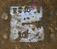
We came home, showered and was about to eat lunch when this photo was texted to me.

imagejpeg_0_.jpg


By 1PM I had picked up my brother and we were on our way back. Arriving there the owner was working and told us to drive there ourselves. When we examined the stone nothing was incised on the top side. I started to dig around the edges hoping to pull it up enough to see the opposite side; however, when my brother and I pulled on the stone it would not budge. After 20 minutes of frustration we gave up. We headed back and noticed the property owner was not home so we left for home ourselves. A short distance down the road we ran into him and he persuaded us to return and he would help us out.

In no time at all we had the stone pulled up but unfortunately nothing again was incised on the back side. I then realized we had the second stone mentioned in the deed that was side by side with the ABM 1840 stone.

But that is not the end of the story. After coming home and looking over his photo in my computer, I now believe it is the 1840 stone. If you look closely you can see the number 1 and the number 8. The sandstone is just seriously worn. And some of the markings above it may be letters as well.


18.jpg


I should have spent more time and cleaned it off when we were digging around it.


DSC_4332a.jpg


Aaron B. Moore was born 4/18/1807 and died one day short of his 70th birthday on 4/17/1877. Jessica and I visited his grave in the Old Lumberton Cemetery.


DSC_4263a.jpg


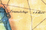
I was sent the below photo by Richard Franzen of the Tabernacle Historical Society showing that Aaron B. Moore lived on what today is Powell Place road in the Tabernacle township "Friendship" near camp Inawendiwin.

1859 map_.jpg


Read more about Aaron B. Moore. FYI the info there is incomplete. I believe he had well over 10 children.


Attachments

  • 1859 map_.jpg
    1859 map_.jpg
    803 KB · Views: 81

Oriental

Explorer
Apr 21, 2005
253
132
Very cool Guy!

I have done some fairly extensive research on the Friendship Saw Mill and while Aaron B. Moore certainly owned a share of that enterprise, I do not believe he ever made his residence there. Aaron was probably raised at Fox Chase, a farm and tavern that once stood on the site of Seneca High School. As a grown man he was among the largest landowners in the area. His homestead was called the Oakshade Farm which stood near the intersection of 206 and Carranza Road (see the first image). Interestingly, a third road (Old Indian Mills Road) joins the other two at that location. Years ago, the first section of Old Indian Mills Road was known as Oakshade Road since it led to that homestead. Indeed, if you were to follow that road today, you can still see the old path as it continues into the woods only to re-emerge on the other side of Medford Lakes-Tabernacle Road where it is still known as Oakshade Road (see the second image).


1654478269212.png

1654478980447.png
 

Oriental

Explorer
Apr 21, 2005
253
132
Incidentally, A. B. Moore and his wife Achsah Bozarth founded the cranberry bogs at Moore's Meadow. I guess the deeds you were looking at were related to that property of some nearby land. The interesting arrangement of the bogs at Moore's Meadow is due to his many children each getting approximately 80 acres of the property. They are laid out in long narrow sections as seen on the topographic maps. Somewhere I have a list of which parcel was given to which child.

1654479888473.png
 

Teegate

Administrator
Site Administrator
Sep 17, 2002
25,602
8,180
Thanks Oriental. Heading to work so I will respond later. However, this shows a ABM stone which was one of his corners at Moores Meadow and Birches. You can see it is in a swamp. I waded out there in waders but could not find it. It was there when the state bought Wharton so it either is still there under the ground or missing.

IMG_2720a.jpg
 
  • Like
Reactions: manumuskin

Oriental

Explorer
Apr 21, 2005
253
132
Guy, I always look forward to reading about your adventures in the woods. My guess is that there are many folks here who enjoy seeing what you discovered even though we rarely have anything to contribute or add to the conversation. PLEASE keep it coming!

For what it's worth, the early deeds I have viewed call the tract Sheep's Neck or Sheep's Neck Pasture. I wish I knew why. Nearby is Lamb's Swamp but I think that name might come from a person and not the animal.
 

Teegate

Administrator
Site Administrator
Sep 17, 2002
25,602
8,180
Oriental,

There is a chance that since he owned property in the area he also owned that place and stayed there rather than take a carriage two miles in a straight line back to his main home.

The map I posted was from 1859.
 

Teegate

Administrator
Site Administrator
Sep 17, 2002
25,602
8,180
Yesterday, Jessica and I wanted to clean up some loose ends and find the state monuments that are at the locations of stones we or myself and manumuskin found in the past. Both locations are in the Tylertown Feedstrip area.

This is the first time we have been there in mid June and it is really dense. Our first stop was this large stone manumuskin and I found in 2009.


IMG_3344a.jpg


We worked hard on this one and finially came up with the monument which is marked wrong. It should be 465.

DSC_4410a.jpg


Nearby we had to dig about 4 inches for this one on the slope of a hill. Usually the hill washes away exposing the monument but this one covered it up.

DSC_4400a.jpg


DSC_4403a.jpg


Earlier we found this large dead pine snake in the road. Don't let the serious environmentalists let you think that motorcycles in the woods are the main cause of death for them.

We looked around the area real quick while standing in the road and we agreed we need to explore there more. Jessica then dragged the snake off to the side of the road.

DSC_4413a.jpg


In the middle of an intersection in Greenwood we found one of these on each side of the road. Someone spent quite a bit of time collecting all of this.


DSC_4414a.jpg


DSC_4415a.jpg


Then later this afternoon I visited my dad in the cemetery.
 

Attachments

  • DSC_4410a.jpg
    DSC_4410a.jpg
    245.2 KB · Views: 66
Last edited:
Top