
Goshen in Camden or Burlington?
- Thread starter Neil in SJ
- Start date
You are using an out of date browser. It may not display this or other websites correctly.
You should upgrade or use an alternative browser.
You should upgrade or use an alternative browser.
Largo and All,
Here is another addition to the Raleigh Land Improvement sightings. This one is semi near the race track mentioned in recent posts.

http://maps.google.com/maps?q=39.72...195&spn=0.005916,0.015256&t=k&om=1&iwloc=addr
Guy
Here is another addition to the Raleigh Land Improvement sightings. This one is semi near the race track mentioned in recent posts.
http://maps.google.com/maps?q=39.72...195&spn=0.005916,0.015256&t=k&om=1&iwloc=addr
Guy
It came to me while reading on another matter that it was in Pearce's "Heart Of The Pines" that I saw an extensive piece on the Raleigh Land Development Co. and it's Proprietors/partners, inclusive of a proposed community map. Check it out.
Thanks for the map tidbit Guy.
So, while driving by it today while off work, it occured to me...doesn't all this still basically put Goshen in CamCo, not BurlCo?
That was the original thread question right?
G.
Thanks for the map tidbit Guy.
So, while driving by it today while off work, it occured to me...doesn't all this still basically put Goshen in CamCo, not BurlCo?
That was the original thread question right?
G.
I figured I'd revive this thread. I've seen Goshen Neck mentioned in several threads, especially the Locks Bridge thread. I think this deserves its own thread though.
I've spent a lot of time around here and plan to explore more this fall and winter. I'd like to hear everyone's input since I know little is documented about this area. I'm amazed at the links that this location has to many others in the area. Atco Lake being one of them.
http://westjerseyhistory.org/articles/atcolake/index.shtml
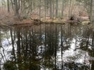
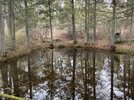
it’s been a while since we’ve talked about Goshen Neck. Over the last few months we’ve been exploring around Goshen. Today we explored all along the earthen dam down stream from Old Atsion Road which formed Goshen Pond (not to be confused with what is called Goshen Pond today). The earthen dam is about 700’ long and in the middle it is clear that there was a spillway at one time probably for a mill.


It is surrounded by large cedar and pine trees. Looking back across it toward the dam. I’m thinking the spillway was filled in when the mill out lived it’s usefulness

Turning around from there it’s clear the canal from the spillway continued on downstream.

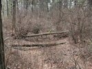
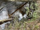
After getting back on the dam we followed it all the way to where the Mullica breaches it. There was some timbers there some looked newer but some looked much older.

We definitely will be exploring more in that area. You never know what you might find. Piano lessons anyone.

It is surrounded by large cedar and pine trees. Looking back across it toward the dam. I’m thinking the spillway was filled in when the mill out lived it’s usefulness
Turning around from there it’s clear the canal from the spillway continued on downstream.
After getting back on the dam we followed it all the way to where the Mullica breaches it. There was some timbers there some looked newer but some looked much older.
We definitely will be exploring more in that area. You never know what you might find. Piano lessons anyone.
Attachments
-
 B9C07BEE-CD53-471B-B277-6461739386A6.jpeg171.4 KB · Views: 202
 -
 2CAA977A-E53F-490B-89E8-BDA9898BC2DA.jpeg182.6 KB · Views: 194
 -
 FF6C8584-0407-4256-9112-23A486ED90CE.jpeg181.6 KB · Views: 189
 -
 DA8C3A3C-3450-46B5-A45D-A993CD11238D.jpeg197.2 KB · Views: 195
 -
 90C96FDE-83AC-435F-891F-84AC955353A0.jpeg159.5 KB · Views: 195
Last edited:

Nice report. I have a theory that the canal, given it’s unusual length, allowed bog iron collection from the mullica river bed by diverting the water and thus lowering the levels of the river.
This probably would have been winter collection by Charles Read.
I recollect that had an agreement with Inskip. He could collect bog iron but couldn’t erect a competing sawmill. I might have to double check that.
This probably would have been winter collection by Charles Read.
I recollect that had an agreement with Inskip. He could collect bog iron but couldn’t erect a competing sawmill. I might have to double check that.
Given some of our past discussions I have given that theory some thought. In Jerseymans post #8 on this thread he identifies 3 mills around the pond. I’m guessing they were in operations at different times. I’ve identified the three mills in the below picture. They only mill that would still be in operation if the canal diverted the Mullica would be number 2. It is located on the canal just below the dam but before the merge back into the river. The green arrows point to the canal and the yellow line represents the earthen dam. The blue is the the trail race and pond that I just posted.Nice report. I have a theory that the canal, given it’s unusual length, allowed bog iron collection from the mullica river bed by diverting the water and thus lowering the levels of the river.
This probably would have been winter collection by Charles Read.
I recollect that had an agreement with Inskip. He could collect bog iron but couldn’t erect a competing sawmill. I might have to double check that.
So my question would be what came first the dam or the canal. I’m thinking the dam came first and the canal after to bypass it. Also food for thought. I’ve noticed the area below the dam seems more disturbed then above. Could they have used the dam to divert the river by opening up a different section so they could collect bog iron.
Last edited:
It is interesting to note that exactly 18 years ago today Ben and I were at #3. To be more specific, we were at the green arrow pointing from #2.

Yes that’s #2. It’s just downstream of the earthen damIt is interesting to note that exactly 18 years ago today Ben and I were at #3. To be more specific, we were at the green arrow pointing from #2.
View attachment 19191
Here to be exact
Last edited:
Yes, my GPS cords have it there.
39.758111
-74.776889
I know I've seen it done before but I can't seem to get the "exaggeration" to change
Click the wrench icon (or go to the main menu on the mobile app)
Now click exaggeration
Set whatever you like with the slider and click the Save button.
A few points might be confusing however... First, each 3d map has its own setting, so be sure you are viewing the desired map BEFORE you go to the exaggeration menu. Second, this is a "local preference" that only affects the device you are using. The exaggeration setting does not become part of a link, so the map my look different to the person who clicks your link (depending on their setting).
Finally, this setting has NO EFFECT when you look at a traditional top-down map view. It is only visible when you tilt the map in 3d view. So, using your link here is some extreme 8x exaggeration in 3d view
Great image you provided and thoughtful questions! I agree that the dam is older than the canal. Sawmills existing there as early as the 1720’s. Charles Read’s interest in bog iron was mid 1760’s. So the dam was very likely the predecessor. Providing my theory in the purpose for the canal is correct (for winter iron harvest from mullica).Given some of our past discussions I have given that theory some thought. In Jerseymans post #8 on this thread he identifies 3 mills around the pond. I’m guessing they were in operations at different times. I’ve identified the three mills in the below picture. They only mill that would still be in operation if the canal diverted the Mullica would be number 2. It is located on the canal just below the dam but before the merge back into the river. The green arrows point to the canal and the yellow line represents the earthen dam. The blue is the the trail race and pond that I just posted.
View attachment 19188
So my question would be what came first the dam or the canal. I’m thinking the dam came first and the canal after to bypass it. Also food for thought. I’ve noticed the area below the dam seems more disturbed then above. Could they have used the dam to divert the river by opening up a different section so they could collect bog iron.
Now, there might be a problem with the assumption that mills 1 and 2 were in fact mills. How do we know? It is a logical assumption, but perhaps not factual. I want to visit the locations again to see if there is other evidence of mills being there. Perhaps 1 is not mill ruins, but the lock, or gate used to divert the water to the canal from the mullica. Is it right at the confluence?
2 could be another gate, that allowed the canal to flow back to the mullica to provide power to mill 3 (which was definitely a mill),
Or bypass the mill entirely and return to the mullica below the dam and mill 3.
During the 1700’s the “mini ice age” was in effect and ice was a serious problem for water wheels in the winter. Mill 3 may not have been in operation at the same time the iron was being harvested.
In my head this all adds up nicely, but it is all speculation.
I thought the same thing about the mills. I was always told both location 1 and 2 were mills. Location 1 specifically being Inskeeps mill. I’ve never had any reason not to believe it but I don’t have any proof. Mill 1 was completely exposed this summer and exploring it I’m fairly certain it was a mill that spanned the Mullica and it is just downstream of where the canal splits off.Great image you provided and thoughtful questions! I agree that the dam is older than the canal. Sawmills existing there as early as the 1720’s. Charles Read’s interest in bog iron was mid 1760’s. So the dam was very likely the predecessor. Providing my theory in the purpose for the canal is correct (for winter iron harvest from mullica).
Now, there might be a problem with the assumption that mills 1 and 2 were in fact mills. How do we know? It is a logical assumption, but perhaps not factual. I want to visit the locations again to see if there is other evidence of mills being there. Perhaps 1 is not mill ruins, but the lock, or gate used to divert the water to the canal from the mullica. Is it right at the confluence?
2 could be another gate, that allowed the canal to flow back to the mullica to provide power to mill 3 (which was definitely a mill),
Or bypass the mill entirely and return to the mullica below the dam and mill 3.
During the 1700’s the “mini ice age” was in effect and ice was a serious problem for water wheels in the winter. Mill 3 may not have been in operation at the same time the iron was being harvested.
In my head this all adds up nicely, but it is all speculation.
Mill 2 I question a little more. It does span the canal and is almost exactly where the canal breaches the dam. A few weeks ago it was almost completely exposed but I didn’t get a chance to really check it out or get pictures. I will go back and check it out when I get a chance. If in fact all three locations were sawmills I’m curious which would be the newest and which the oldest. Also I would expect the cranberry operation to be about 1760 as well. The area just upstream and west of mill 3 looked like it could have been a cranberry bog.
Last edited:
Gee, wish I went there during the dryness of this summer, but it seems like I’m always working.
Cranberry cultivation wasn’t a thing till the 1830’s in the pinebarrens so the cranberry operations were quite a bit after that.
Cranberry cultivation wasn’t a thing till the 1830’s in the pinebarrens so the cranberry operations were quite a bit after that.
So, the canal diversion could have been seasonal. Just in the winter when the mills weren’t running. There must have been significant iron in that stretch. I wonder if lowering the water also aided in repair work to the mill components and the canal allowed easier passage for bog iron boats . Maybe the whole canal was just a giant lock.
Finally, this setting has NO EFFECT when you look at a traditional top-down map view. It is only visible when you tilt the map in 3d view.
That was it, Thanks!
Another thought. Could that canal been a bypass for for the two sawmills (#1 and #3) and the pond all together from bog iron further upstream.So, the canal diversion could have been seasonal. Just in the winter when the mills weren’t running. There must have been significant iron in that stretch. I wonder if lowering the water also aided in repair work to the mill components and the canal allowed easier passage for bog iron boats . Maybe the whole canal was just a giant lock.