A Look Inside Lenape Farms WMA

RednekF350

Piney
Feb 20, 2004
4,944
3,080
Pestletown, N.J.
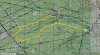
My son and I spent the better part of yesterday exploring the new Tuckahoe WMA Lenape Farms Unit in Estell Manor. This is the monstrous acquisition that was executed by the State this year on both sides of Route 50.

We went into the east side off of Steelmantown Road first and we were surprised to find that access into the former clubhouse area has already been terminated by F&W. We parked at a gate and walked about a half mile to the heart of the former clubhouse, trap and skeet fields.

We encountered a F&W worker who told us that access throughout much of the acquistion is going to be restricted to foot access only. The clubhouse, which is today hosting a two day trapper education class, will only be accessible for special events such as that. The road into the clubhouse is a large gravel surfaced road but secondary roads within the acquistion are smalle and wetter and it wouldn't take long to turn them into muddy mini-disaster areas. The apparent light, seasonal use of the more remote sections of the tract by the former owners is about all the roads would adequately handle.

We left the main entrance and went south on 50 to the southern border off of Gibson's Creek Road. We entered a small path that is shown as a road on the USGS maps and it traverses some beautiful woods and wetlands. Honestly though, the woods I experienced in the Manahawkin Swamp a few weeks ago were far more impressive and awe inspiring.

A remote impoundment off of Jackson Creek had our interest as a potential waterfowling spot and we hiked in about a mile to get to it. It certainly looked good when we got there but the walk-in options would be imposing if we were carrying decoys and guns.

The last area we checked was the west side of 50 and Walker's Forge Road. There is very limited access at this point with most gates still locked. Posted signs have been removed and WMA signs are popping up in more locations. According to the guy we talked to, vehicular access to this area will likely be tightly restricted as well.

This an impressive piece of land and it is hard to fathom that it was all privately owned at one time and almost entirely fenced. I expected to see deer sign everywhere within these fenced limits but such was not the case. I did see a lot of evidence of beaver, otter and coyote.

I was just a little disappointed with the limited access but after seeing the environmental sensitivity of the areas and the light duty conditions of the internal roads, the State is most certainly doing the right thing. My son and I agreed that much of the area will be prime hunting area for those willing to make the effort.

Explore it now in its pristine condition.

Scott

Some photos.

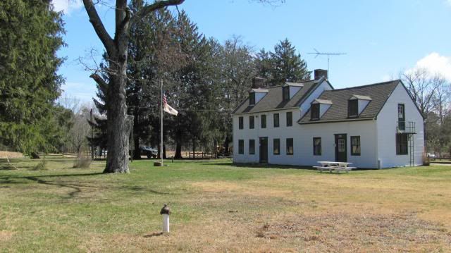
The clubhouse. These men were living large and in charge.
img_1680_zps96c5114b.jpg


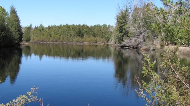
The pond next to the clubhouse. This had a park bench and manicured lawn next to it. I chose the wild view.
img_1684_zpsf93fd9e5.jpg


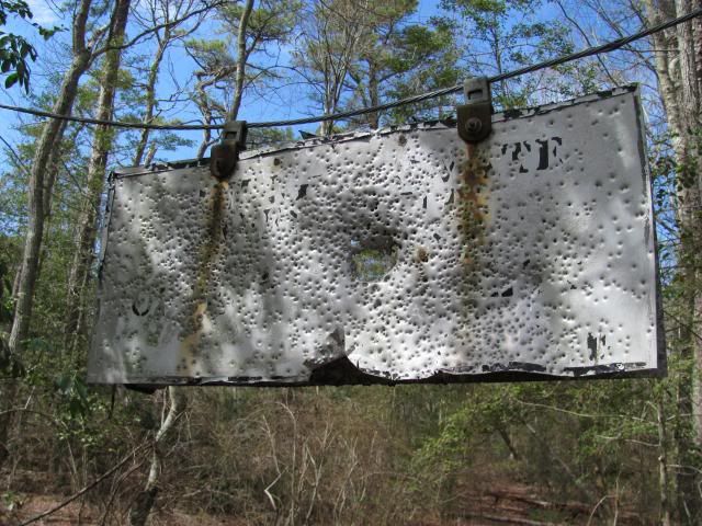
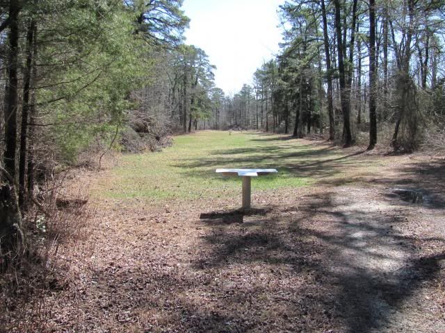
A 350 yard rifle range with machined aluminum bench rest rifle tables. This will likely be abandoned.
img_1683_zpsdea6013b.jpg


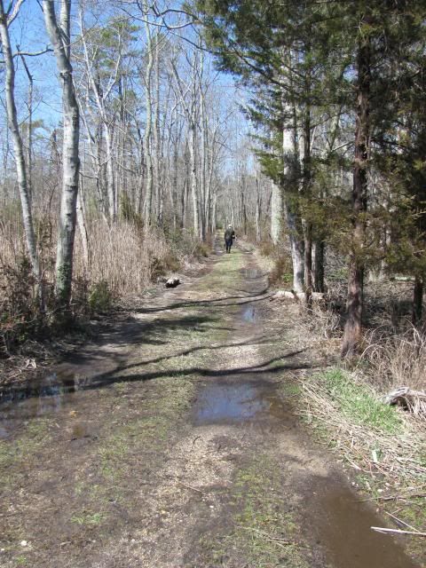
A lightly used and grass covered wetland road leading to the club's private boat ramp on Stephen's Creek. Two passes by an A-hole in a blown Chevy with 44's and this road would be closed forever.
img_1686_zps21a2a572.jpg
 

Y-BUC-BILL

Explorer
Mar 9, 2007
129
26
Hi Scott...Great report on a great piece of property.Looks like the State Division of Fish and Wildlife will control who use's it.Good or bad??
 

RednekF350

Piney
Feb 20, 2004
4,944
3,080
Pestletown, N.J.
Hi Scott...Great report on a great piece of property.Looks like the State Division of Fish and Wildlife will control who use's it.Good or bad??

Hope your feeling well Bill, looking forward to seeing you back at the club.

As to your question, you know what my answer answer is. Good.
:dance:

Scott
 

woodjin

Piney
Nov 8, 2004
4,338
326
Near Mt. Misery
Nice report scott. were you under the impression that there were sections that are relatively untouched/remote/virgin? Or did the former owners trail up the place pretty good?

Jeff
 

RednekF350

Piney
Feb 20, 2004
4,944
3,080
Pestletown, N.J.
Nice report scott. were you under the impression that there were sections that are relatively untouched/remote/virgin? Or did the former owners trail up the place pretty good?

Jeff
Actually Jeff, the roads you see on the USGS maps within the property limits are pretty much it. Anywhere you see one of their bird hunting fields you will have a small connection to the larger roads.

We were trying to figure out how they performed their deer hunts because we saw no evidence of stands or blinds. We did see numbered plates on trees along some of the roads that we were assuming were stations at which the hunters would stand.
 

Boyd

Administrator
Staff member
Site Administrator
Jul 31, 2004
9,504
2,766
Ben's Branch, Stephen Creek
A week or two ago I noticed that the gate opposite Maple Lake had been removed and today I finally ventured inside for a brief look around. Vehicular access is now possible via a dirt road about 1.5 miles in length. The magenta line on the map below shows my track. The road leads to a dead end where you must turn around and return by the same route. There are some pretty deep puddles on the road from the recent storms, but nothing that a little common sense and 4 wheel drive can't handle.

When you reach the Western end, there's a closed gate (like the padlocked barricades found in other WMA's) at Estell and 9th Ave. You can turn South on Estell Ave but there's a large tree that has fallen and blocked the road. I took a short walk past the tree to the open field that can be seen just South of my track below. If that tree were gone, it might be possible to drive further. But this area is covered with high grass, and even though some people on this site doubt the chiggers have appeared yet, I didn't want to test that theory myself. :D

So - believe it or not - this was my first trip inside the new WMA, which is almost literally in my back yard! Here's a link to the road on NJPB maps so you can orient yourself: http://maps.njpinebarrens.com/#lat=39.3999561896023&lng=-74.79127407073975&z=15&type=topo&gpx=

This is the only road that is not gated off, and also the only vehicle entrance to the WMA (aside from the short road leading to the parking area at Stephen Lake.

lenape.jpg
 

manumuskin

Piney
Jul 20, 2003
8,552
2,465
59
millville nj
www.youtube.com
I just took a first time ever drive through Lenape farms and this is what I come up with.Purple circles are open access.Red squares are gates that I remember being there and closed.Black trails are trails I followed and they started getting tight so I turned around.This is quite a big patch of woods and a very nice drive.Like Boyd says nothing common sense can't handle.I"d take it slow in a low clearance vehicle but other then that I wouldn't worry.
 

Attachments

  • lenape farms.jpg
    lenape farms.jpg
    333.9 KB · Views: 729

Spung-Man

Explorer
Jan 5, 2009
976
656
64
Richland, NJ
loki.stockton.edu
This an impressive piece of land and it is hard to fathom that it was all privately owned at one time and almost entirely fenced. I expected to see deer sign everywhere within these fenced limits but such was not the case. I did see a lot of evidence of beaver, otter and coyote.

Explore it now in its pristine condition.

It’s amazing how quickly the Pine Barrens reclaims the human footprint. The eastern Lenape Farms land nearest the Great Egg Harbor River was intensively farmed since colonial times but was abandoned with the establishment of Bethlehem Loading Company's munitions plant, and in the interior was once Old Forgotten Ingersol’s, a forest-product settlement that provided ship-timber, charcoal, and naval stores, and was even reputed to have an illegal blooomery to provide the Steelman boatyard with bootleg iron. So heavily cut was this area that the location was called the Risley Plain, as in a Pine Plain.

Can anyone tell me the location of Ingersol Pond, another long-gone and dried up Pine Barrens spung?

The section above Cumberland Avenue was surveyed c.1882 into eighty 15-acre lots to become the Russian Jewish settlement of Burbridge Village, named for Union General Gano Burbridge. The scheme was based on a sorghum subsidy for sugar production at a mill down in Rio Grande, Cape May County. Over 28 families settled then abandoned the tract.

I say no more, because researcher Carl Farrell will present an amazing account of ethnic settlement during the 2016 Historical Society of Hamilton Township Speakers’ Series at the Presbyterian Church in Mays Landing,, Wednesday,April 13, 2016. The program is titled “The Forgotten Colony at Estellville.” It is an incredible story.

Also see: Munn D. 2007. Atlantic County Game Preserve; a Retrospective History. 100th Anniversary 1905–2005. City of Estell Manor, NJ: Atlantic County Game Preserve. 91 pp.

S-M
 
Last edited:

manumuskin

Piney
Jul 20, 2003
8,552
2,465
59
millville nj
www.youtube.com
Al,
I assume yellow is the road you drove ?
I drove all but the northern leg.I exited at the NW corner because it was getting dark and I have no cell and I knew Momma would be worrying but I seen the northern leg was open and looked as good as the rest of it and I know the gate was open to the north of the pond so there should be no problem with it.I intend to go out and drive it all my next days off and take my time so i can get out and check out the area.I was out checking the roads east of 50 because i had been stone hunting that side of the road last week and seen some open roads i didn't have time to check because of darkness.well when I exited Steelman landing road that i had never been down before I noticed the gate across 50 was open so in I went.At this time it was after 5pm and getting dark fast.I didn't realize the woods were that big or i would have waited.I"ll report here when i drive the northern leg but the rest of it was so good that the north road should be too but i do notice a small swamp crossing that road on the topo but see absolutely no major holes on any aerial.I imagine the roads are so decent from years of being maintained by the owners.We'll see how that holds out with the state owning it.I notice they usually maintain their roads after they dry out in the spring once the hunters get done tearing them up just from use and being muddy.I thought i could drive from steelman road past a house and pond i seen on the aerials and pop out at another gate down south on 50 but there are gates north and south of the house and one blocking steelman landing as well.
 

manumuskin

Piney
Jul 20, 2003
8,552
2,465
59
millville nj
www.youtube.com
It’s amazing how quickly the Pine Barrens reclaims the human footprint. The eastern Lenape Farms land nearest the Great Egg Harbor River was intensively farmed since colonial times but was abandoned with the establishment of Bethlehem Loading Company's munitions plant, and in the interior was once Old Forgotten Ingersol’s, a forest-product settlement that provided ship-timber, charcoal, and naval stores, and was even reputed to have an illegal blooomery to provide the Steelman boatyard with bootleg iron. So heavily cut was this area that the location was called the Risley Plain, as in a Pine Plain.

Can anyone tell me the location of Ingersol Pond, another long-gone and dried up Pine Barrens spung?

The section above Cumberland Avenue was surveyed c.1882 into eighty 15-acre lots to become the Russian Jewish settlement of Burbridge Village, named for Union General Gano Burbridge. The scheme was based on a sorghum subsidy for sugar production at a mill down in Rio Grande, Cape May County. Over 28 families settled then abandoned the tract.

I say no more, because researcher Carl Farrell will present an amazing account of ethnic settlement during the 2016 Historical Society of Hamilton Township Speakers’ Series at the Presbyterian Church in Mays Landing,, Wednesday,April 13, 2016. The program is titled “The Forgotten Colony at Estellville.” It is an incredible story.

Also see: Munn D. 2007. Atlantic County Game Preserve; a Retrospective History. 100th Anniversary 1905–2005. City of Estell Manor, NJ: Atlantic County Game Preserve. 91 pp.

S-M
I just found this looking on the hartman maps for info on something else altogether and I remembered your question.see map attached. No pond there now but theirs a swamp.
http://maps.njpinebarrens.com/#lat=39.35243730871651&lng=-74.77506715457918&z=17&type=nj1930&gpx=
 

Attachments

  • Ingersol Pond.jpg
    Ingersol Pond.jpg
    220.1 KB · Views: 477
  • Like
Reactions: Spung-Man

92 Blazer Jeff

Explorer
Aug 24, 2015
259
100
GLASSBORO,NJ
The gates may be open for hunting season. The Glassboro WMA is only open to vehicles during hunting season and closed to only foot & bicycles
the rest of the year.
 

Boyd

Administrator
Staff member
Site Administrator
Jul 31, 2004
9,504
2,766
Ben's Branch, Stephen Creek
While working on a map, I just noticed that the Lenape Farms WMA no longer exists! The Western part has been swallowed up by the Maple Lake WMA and the Eastern part was swallowed by the Tuckahoe WMA. See these maps

http://www.state.nj.us/dep/fgw/pdf/wmamaps/maple_lake.pdf
http://www.state.nj.us/dep/fgw/pdf/wmamaps/tuckahoe.pdf

The little Maple Lake WMA (which is literally my backyard) has grown from its original 500 acres to 5000 acres... it also swallowed up the Gibson Creek WMA.

Have not studied the NJDEP website closely enough to see what other changes have been made, although I also noticed that the Edward C. Bevan WMA is now the Millville WMA. When did that happen? Who was Bevan? Is he now out of favor politically? :p
 
Last edited:
  • Like
Reactions: manumuskin

Rooftree

Explorer
Mar 24, 2017
330
580
78
Haddon Township
I googled. Edward G. Bevan was a senior wildlife manager for State of NJ who died in 1981. He played a vital role in the early efforts of state's Green Acres Program as stated on the link below on his wife, Fola who died in 2007. She was a teacher and President of the Millville Historical Society. Also she was named one of the Cumberland County's ' People of the Century'.

http://www.co.cumberland.nj.us/Fola-Bevan
 
Top