Amatol reports and mapping

gipsie

Explorer
Sep 14, 2008
547
67
55
atlantic county
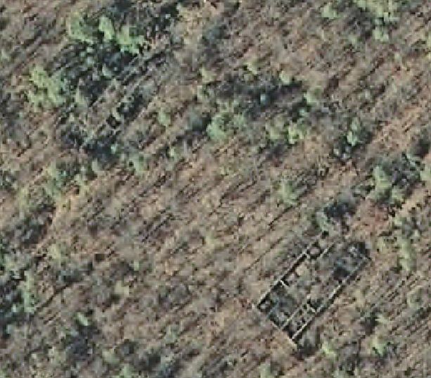
As I have said on the other thread about Amatol, one of my pet projects has been exploring and trying to map out the area. I started this in November or early December with my friend Pete, who was shortly thereafter deployed overseas to Qatar/Iraq. We originally went out there after a new geocache that was published. The description of the area that the cache was supposedly placed listed 6 or more ruins of buildings. We went to the coordinates and they were obviously wrong. There were no ruins (nothing except a deer stand) and no geocache. I had been to the area before and never saw 6+ ruins that close together, so we were immediately intrigued. A few days later, we met out there and began exploring the area. We walked along the longitude and then the latitude lines, thinking that they had been mistaken. We eventually found the ruins of the 9 (not 6) buildings. The ruins were on private property (and after running into some guys from the gun club they belonged to, I have since acquired permission to explore the area).

When Pete and I were out there exploring, we marked a bunch of waypoints on our GPS units with hopes of getting back out there to explore again. I had it in my head that I would get to all the spots and take photos, do research and map out the entire area before he came back from deployment. Well, life once again got in the way and realizing that he was coming back in a couple of weeks, I decided to head out there on Thursday and get some of the picture taking/mapping out of the way. I had full intentions of going to all the waypoints that we marked, but only made it about 1/3 of the way. I spent 4-5 hours in the area and started to get spooked when I kept hearing other people in the area.

My idea of this thread is to keep you all updated on my progress of exploration and get your ideas/thoughts on some of the areas/ruins I have found. The next couple of posts will document....
 

gipsie

Explorer
Sep 14, 2008
547
67
55
atlantic county
The first day...

Near where I parked, there was a foundation that was very close to the road. No ruins, no building. Just a foundation that looked like it had "steps" and about 6 or 7 rooms.

I then went to what I originally had marked as a "hole". It brought me to a concrete hole in the ground. The hole was about 3.5 ft x 3.5 ft and was around 6 foot deep. 3 of the sides had bolts sticking out of it and the fourth side had some sort of brackets. 4 of them, all in a row. Not sure what this could have been. Any ideas?

bolts on far side of hole.jpg6 ft deep hole.jpgbrackets around hole.jpg
 

gipsie

Explorer
Sep 14, 2008
547
67
55
atlantic county
My second stop took me to what I believe to be the "pouring and cooling" buildings. These buildings are pretty intact ruins. There is an angle of about 15-25 degrees of the outer walls pointing inward which made me believe that they are the P&C buildings. There were three of them in a row about 250' distance between them. The buildings themselves had 3 "rows". An inner "hallway" and two outer rows that ran the length of the "hallway". Each row was no more than 10-12 ft wide. They ran about 60-75 ft. There were openings between the rows, too low to be windows. The ruins themselves were very overgrown but easy to walk through the rows. The back walls on two of the buildings were collapsed but one was still intact. The front of the buildings (and I am just guessing front and back) had flat areas that were almost like patios. And an outer wall surrounding the "patio" area. On the patio I found a chair sitting there facing the ruins and a not too far away tricycle....

pouring and cooling building rear.jpgpouring and cooling building 1.jpgsecond P&C building from inside.jpgpouring and cooling building patio.jpgpouring and cooling building front half.jpg
pencil.png
 

gipsie

Explorer
Sep 14, 2008
547
67
55
atlantic county
The thing that really confused me was this "trench".

I had it marked from my last visit. A couple of feet deep and maybe 2 ft wide (if that), I had noticed a "pit". The indentation in the ground measured about a 3-4 ft diameter. Just a depression in the earth, but if you look closely there is a "tunnel" through the earth that becomes a trench. The depression immediately opens into a trench, concreted on both sides that ran about 250-300 feet in a straight line. I have been trying to figure out what it was, but there was no escape. It started at the concrete opening, ran for about 300 ft. and then just ended. Anyone knows what this may be?


far end of trench.jpgmiddle of trench.jpg
 

Boyd

Administrator
Staff member
Site Administrator
Jul 31, 2004
9,505
2,766
Ben's Branch, Stephen Creek
I have looked at some fair-sized ruins/foundations on the NJ 2007 aerials and wondered about them - right around here: http://maps.njpinebarrens.com/#lat=39.603472846501084&lng=-74.73918557167053&z=17&type=nj2007&gpx=

Here is a full resolution screenshot, there appear to be two similarly sized buildings, one in the lower right and the other overgrown one in the upper left. If you browse the full res imagery, there appear to be others also. I really should get up there and explore one of these days!

amotol01.jpg
 

gipsie

Explorer
Sep 14, 2008
547
67
55
atlantic county
Boyd,

I have 70-80% of the area mapped out on my GPSr. Just haven't overlayed it with the old maps, topos and aerials yet. It is a learning process for me.

I believe that the area you are showing is where the old pouring and cooling buildings are. I don't think those buildings are the ones on private property at that point. But, like I said, I haven't overlayed maps yet. (I am semi-map illiterate, lol...but I am learning).

If you ever want to explore the area, let me know. I can give you the coordinates for most of the ruins that I have found and you can come to your own conclusions!

I only live about 15-20 minutes from there....let me know if you want to head up there one day!
 

gipsie

Explorer
Sep 14, 2008
547
67
55
atlantic county
Yes, that seems right. Sometime today I will post a map with the interesting things that I have found plotted out. I plan on trying to compare it with some of the old maps of the area if I get a chance. I'll keep you updated...
 

Sue Gremlin

Piney
Sep 13, 2005
1,277
233
61
Vicksburg, Michigan
The thing that really confused me was this "trench".

I had it marked from my last visit. A couple of feet deep and maybe 2 ft wide (if that), I had noticed a "pit". The indentation in the ground measured about a 3-4 ft diameter. Just a depression in the earth, but if you look closely there is a "tunnel" through the earth that becomes a trench. The depression immediately opens into a trench, concreted on both sides that ran about 250-300 feet in a straight line. I have been trying to figure out what it was, but there was no escape. It started at the concrete opening, ran for about 300 ft. and then just ended. Anyone knows what this may be?


View attachment 1610View attachment 1611
We guessed that this was some sort of transport system for delicate explosives. I think my husband actually knows a lot more about this than me, but I think we figured they had some sort of trolley system. Jiggling nitroglycerine too much might cause you to have a bad day.
 

gipsie

Explorer
Sep 14, 2008
547
67
55
atlantic county
That is a pretty good thought Sue. If Joe has some more info, I would definitely be interested in hearing it.

And yes...that chair is STILL there. Along with the tricycle....
 

Sue Gremlin

Piney
Sep 13, 2005
1,277
233
61
Vicksburg, Michigan
I just asked Joe, he doesn't know any more than that. We guessed that it was set up to house some sort of conveyor to move things from building to building. The buildings would have had to have been a certain distance apart to keep a chain reaction from happening should someone try to light a cigarette in the wrong place or something. We could be totally wrong, by the way. :)
 

Kevinhooa

Explorer
Mar 12, 2008
332
25
41
Hammonton, NJ.
www.flickr.com
Looks like you're having fun over the Gipsie. As for those trenches - the ones in the really long rectangular buildings
were for the conveyor belts. Some of the bigger pouring and cooling buildings only have a shelf where one side of the belt could be accessed by someone standing to roll the shells onto tables, and the other side of the room was floor level for re-loading on to the next building. I do know that once the railcars pulled into the uloading buildings, they were never lifted by the workers right on up to the final building, a feature that enabled several shell companies built during that time to produce so much ammo in such a short time. Everything was moved on roller tables, or conveyor belts. The other skinny trenches were for drainage where water could drain after each room was sprayed down with water to eliminate the explosive dust build-up. I'm not sure what they did with the dust/dirt/water once it drained down those trenches, they might have covered it with earth, or maybe pulled it back out with wooden shovels to get rid of it. Almost all of the conveyor lines can still be followed by the stucco lathe rubble that lined the walls. An interesting thing I found when I tried to match up where the pouring buildings were in relation with what was there today, one was missing in one of the plants (6" or 8", I forget) right near where the curve was for the track. I'm not sure it it was never built as some of the other buildings in the plant, or the building of the track took destroyed it. The plant really has so much to explore, I only wish it was completely open to the public like Bethlehem.
 
Apr 6, 2004
3,607
552
Galloway
http://maps.njpinebarrens.com/#lat=39.606705379770396&lng=-74.65953595909116&z=17&type=nj1930&gpx=

There are structures here that I believe are part of Amatol. There are three concrete blocks that extend about 3 feet from the ground. They have perfectly round holes at the top, about 2 feet across with steel service ladders in them. They are all aligned with one another, and it looks like they were all once connected by pipes. Anyone familiar with these structures or have an ides what they were? I was thinking that their proximity to Lucas Branch (they are only about 30 feet from the stream) indicates that they might have been used for pumping water to the town.
 

gipsie

Explorer
Sep 14, 2008
547
67
55
atlantic county
Ooooh, I forgot all about this thread!!!!!! I have some more info about this area in my notes that I collected before my world got crazy, hehe. I will find my notes sometime this week, I do remember those "trenches" did, at one time, have some sort of cable through them I will check and get back to you all...........
 
Apr 6, 2004
3,607
552
Galloway
This map answered my question: http://amatol.atlantic.edu/p-013_The_Development.html

The sewage disposal plant. How 'bout that?


http://maps.njpinebarrens.com/#lat=39.606705379770396&lng=-74.65953595909116&z=17&type=nj1930&gpx=

There are structures here that I believe are part of Amatol. There are three concrete blocks that extend about 3 feet from the ground. They have perfectly round holes at the top, about 2 feet across with steel service ladders in them. They are all aligned with one another, and it looks like they were all once connected by pipes. Anyone familiar with these structures or have an ides what they were? I was thinking that their proximity to Lucas Branch (they are only about 30 feet from the stream) indicates that they might have been used for pumping water to the town.
 
  • Like
Reactions: Boyd

Kevinhooa

Explorer
Mar 12, 2008
332
25
41
Hammonton, NJ.
www.flickr.com
Gabe,

I believe what you are referring to are manholes. Like mentioned above the sewage system went out north out of town and bounces along before getting to what looks like "settling ponds" which are still lined with wood to this day. The system continued north heading towards Indian Cabin Rd before finally dumping into a drainage field that is now split in half by Indian Cabin Rd. There are manholes all over the place so be careful when checking things out. It looks to me like all the connecting pipe (terracotta?) was dug up at some point and taken. So it's fairly obvious how the system was mapped, or mostly mapped I should say. Not really sure if all of that pipe was taken. There is a trail of sorts off of Indain Cabin that almost directly follows this pipe system for most of the way. It's usually flooded pretty bad in the rainy season though.
 
  • Like
Reactions: Boyd
Top