I still owe him a few bits of info. I have to get working on that.Well done.

Lawrence Line Survey
- Thread starter johnnyb
- Start date
You are using an out of date browser. It may not display this or other websites correctly.
You should upgrade or use an alternative browser.
You should upgrade or use an alternative browser.
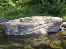
Back in 2015 I happened to be near where the Lawrence Line intersects the Delaware River between NY and PA. I photographed this stone with a hole in it. I believe this is THAT stone, but I didn't find any initials in the stone. I lack the map skills to take this lat/lon and plot it on a map to see if I was correct. If this isn't the correct stone, it's very close to the real one.
Attachments

I lack the map skills to take this lat/lon and plot it on a map to see if I was correct.
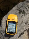
You already have your GPS set to decimal degrees, so it's actually quite easy. North means positive numbers and West is represented by a negative number. So for your first screenshot we get this for Latitude, Longitude
41.71200, -75.05658
Enter those numbers on my maps using the little "sphere" icon on the toolbar
And you get this location, which is (apparently) in the middle of the river.
https://boydsmaps.com/#16.00/41.712000/-75.056580/legacy24k/0.00/0.00
Doing the same for the other screenshot yields this
41.71499, -75.05977
https://boydsmaps.com/#16.00/41.714990/-75.059770/legacy24k/0.00/0.00
You can then switch between other maps and aerials using the map menu button at the top right of the screen.
The location of Anthony's first gps coordinates looks very good on the south side of the river. The last coordinates end up in a field on the north side.
I am unsure what first and last you are referring to. The first cords he posted in post 82 are on the north side of the river in a field.
I think the coordinates in his first screenshot are in the river, as I posted above. I used a topo, but if you look at the Google aerials, it is close to a big rock.

41.71200, -75.05658
41.71200, -75.05658
I ran a line using google Earth from Lawrence Line #10 which I have multiple survey maps giving the same coordinates, all the way past Waterloo Village to the Delaware and it allign very closely with all the points I know and it ends up in the circled area on this map. The left line was Anthony's stone, the center one was the one I originally felt was my correction and the circle is where it runs to.

I think the coordinates in his first screenshot are in the river, as I posted above. I used a topo, but if you look at the Google aerials, it is close to a big rock.
View attachment 18900
41.71200, -75.05658
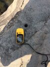
His first image with his GPS is 41.71499 75.05977 and that is not in the river.
That's weird, maybe they display in a different order for you? This is what I see, and the first attachment (the one on the left) is as I described above. The coordinates you posted are in the fourth image in my browser.

Even using the cords in the first photo put it dead in the center of the river. In any event, it may be the proper stone but the line does not line up with it. That may be how it is since Lawrence did have some issues getting it straight.
I think there is some confusion on both sides. I was looking at the cords for the 4th photo and was writing about his "first post." Why do we have conflicting coordinates????
Yeah, definitely some confusion!
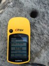
") I was talking about the image IMG_0199.JPG, which is the first attachment (the one on the left) in post #82. The coordinates displayed in that image are 41.71200, -75.05658
I was talking about the image IMG_0199.JPG, which is the first attachment (the one on the left) in post #82. The coordinates displayed in that image are 41.71200, -75.05658