LIDAR enhanced aerial views

manumuskin

Piney
Jul 20, 2003
8,673
2,586
60
millville nj
www.youtube.com
A big update is on the way soon with greatly expanded coverage. :)

View attachment 5429


The contrast and color have been enhanced so it should look better on the GPS screen, but I still need to do some testing.

View attachment 5430

Should be available sometime next week if I don't run into any problems. I will post the download link to this thread.

View attachment 5431
That last photo is my neck of the woods.Thats pickle pond.I have some fond memories of that place:)
 

Boyd

Administrator
Staff member
Site Administrator
Jul 31, 2004
9,828
3,010
Ben's Branch, Stephen Creek
The new version of LIDAR in the Pines is now ready for download at this link:

http://boydsmaps.com/download/LIDAR_in_the_Pines_020.zip

This is a huge update that expands coverage to 64 quads from the previous 22. It also includes full documentation. Another new feature is a neutral background called the blank pines map that you install separately. This is a traditional Garmin map (.img file) that you select from the dropdown menu in Basecamp. When you use the blank pines map along with LIDAR in the Pines, it will supress the display of all other objects, such as the roads and labels from the Basecamp Global Map. This eliminates the need to change the draw order of the individual map files and provides a "clean" display of the LIDAR imagery.

blank_map.JPG


There are many other improvements, including enhanced color and contrast. I was not able to eliminate the lines that separate the individual map quads, however they are now a dark green color that blends in with the map so they aren't very noticeable. The quads now have a number as part of their names that causes them to be listed in order from the Northwest (top left) corner to the Southeast (bottom right) corner of the map.

You may be wondering how I chose the new quads to include in this version since many of them are outside of the Pines boundary. The reason is that I already had most of the raw data on my computer, so creating the new quads was mainly an exercise in combining/processing. My internet connection is very slow and downloading the NJ 2007 aerials is tedious. Each quad requires the download of about 70 files and I end up with data corruption if I try to download more than two or three at a time. This also means that you will probably not see any more big updates for awhile.

You will probably want to remove the previous version from Basecamp before installing the new one. This can be done by right-clicking the LIDAR list that you previously created in Basecamp and choosing "Remove and Delete Unique Content".

delete_content.JPG


Enjoy the new map and let me know what you think!
 
Last edited:
  • Like
Reactions: Menantico and 46er

46er

Piney
Mar 24, 2004
8,837
2,144
Coastal NJ
Ditto what Bob said. Great coverage too!! I will have to try them in BaseCamp, I've been using version 1 in Google Earth.
 
  • Like
Reactions: Boyd

Boyd

Administrator
Staff member
Site Administrator
Jul 31, 2004
9,828
3,010
Ben's Branch, Stephen Creek
Thanks! While I'm not a Basecamp fan, I'm pretty happy with the way this version works along with the blank map. You will notice however that if you "hover" with the cursor you get an "unknown area" bubble. I don't know how to prevent that, but do have an idea of how to make it provide useful feedback.

More about this later, after I try a few things. :)
 

Boyd

Administrator
Staff member
Site Administrator
Jul 31, 2004
9,828
3,010
Ben's Branch, Stephen Creek
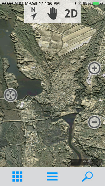
Just a quick update for those that didn't see my thread about the CompeGPS program. I have a test version of LIDAR in the Pines working in the TwoNav app on my iPhone. This needs a lot more work, but I *think* it may be possible to offer the full version of this map for both iOS and Android devices. There's a free version of the app and a paid version for $6. Not completely clear whether the free one can do this (I ended up buying the full version).

https://itunes.apple.com/us/app/twonav-gps-premium/id346996240?mt=8

https://play.google.com/store/apps/details?id=com.compegps.twonav&hl=en

More info to follow, when I have a little more time to spend on this. But I think maps in this app would not have the limitations of the Garmin "custom maps". In other words, you could load all of the pines on your phone and view it in higher quality than the Garmin version. Here's a screenshot of the map on my iPhone 5s.

twonav2.jpg
 
  • Like
Reactions: 46er

Boyd

Administrator
Staff member
Site Administrator
Jul 31, 2004
9,828
3,010
Ben's Branch, Stephen Creek
Another update: I have the full map working on both iOS and Android devices now, it's a seamless map covering the whole pines, no need to load separate quads. File size is one gigabyte. On iOS you can use the TwoNav app, but you need the paid version (which is $6).

https://itunes.apple.com/us/app/twonav-gps-premium/id346996240?mt=8

Also works in the paid version of TwoNav on Android, but I am using it in OruxMaps, which is free. I actually like this app much better, too bad it isn't available on iOS.

https://play.google.com/store/apps/details?id=com.orux.oruxmaps&hl=en

If you'd like to try this, I'll make the map available for download. Will wait to see if anyone is actually interested before providing installation instructions. :)
 
Last edited:
  • Like
Reactions: Menantico
Top