Origins of Pestletown

RednekF350

Piney
Feb 20, 2004
5,054
3,327
Pestletown, N.J.
I have done a lot of casual research on the origins of Pestletown where I live but have never really came up with anything substantive.
The best clue I have had so far is an old gentleman originally from Dutchtown on 206 that told me that there were people by the name of Pestle in Blue Anchor about 50 years ago and that some of them were boat builders.
I have an 1885 map entitled "Town of Waterford" that covers Pestletown but the ownership in the general area is shown on the map as Hurff, Garwood and Neal.
On the map, 3 structures appear one of which still exists.
The map is filed at the Camden County Register of deeds as Map no. 4-1 and I use it for surveying purposes.
Does anyone else have any info on Pestle or Pestletown?
I am going to check the name Pestle at the Register of Deeds the next time I am there to trace the name as a grantor of lands in that area.
Any info would be appreciated.
Scott
 

Piney Roots

New Member
Jul 22, 2024
14
24
Bainbridge Island, WA
Let me just say up front that I am new member of this forum and not a local, and that my overall knowledge of the NJ pine barrens is limited. I should also note that my interest in this specific topic is less geographic than it is genealogical. I am a 6th generation descendant of the German immigrant Sebastian Woos/Woas, who built Shane’s Castle in the area that is now Pestletown in the mid-1700s. My research into him and his family produced a two-part article published in the May and Sep 2023 issues of the Genealogical Magazine of New Jersey. It dispels many of the long-standing myths about this family. If anyone is interested I am happy to provide a copy. In the course of my research I did explore some geographic topics, and I thought this would be a good forum to share them and get feedback from local experts. One topic is the location of the Woos Burial Place (referred to by several 19th century historians such as Prowell, Clement, Stewart and Heston). I am quite certain I have located it in a spot west of Pestletown Road on the north side of Clark’s Branch, but that will be the subject of a separate post. The other topic is the origin of the name of Pestletown. My theory and the evidence to support it are offered below.

The earliest reference to Pestletown I have found to date is on the front page of the 8 Aug 1879 issue of the Camden Daily Post in an anecdotal article describing the courtship of a young lady under the heading “Pestletown” in the “Camden County News” column. The name must have been common enough at that time that the article includes no further description of the location. Another early reference is a 27 Nov 1880 note on p. 3 of the Camden County Courier that reports a child’s burial “in the Catholic cemetery of consecrated ground at Pestletown (that would be today’s Waterford Memorial Park, a separate cemetery from Woos Burial Place). Later that decade a 14 Nov 1887 front-page Camden Daily Post article describes Pestletown as “a small hamlet of five houses, one of which is vacant.” So, the area was referred to as Pestletown by at least 1879 and probably earlier. That name was certainly common enough to appear on USGS and NJ state topo maps of the area by the mid-1880s, and was fairly frequently mentioned in Camden newspapers of that era (at least 32 mentions between 1879 and 1899). But what is the origin of the name?

The earliest origin story I have found is in a 5 Oct 1933 article by Henry Charlton Beck on p. 6 of the Camden Evening Courier: “Questions in the vicinity concerning how Pestletown got its name indicated that it is of Indian origin. There is a Pestle brook in the neighborhood and unquestionably that dubbing came from the well-known Indian utensil. Some of those we saw [said] that there were people named Pestle when the town was carved around and from the Garwood farm.” On p. 219 of his book More Forgotten Towns of Southern New Jersey (1937) Beck repeats this story in a bit more detail and also adds the opinion that the naming of the town after a Pestle family “is doubtful” (on that account he is probably correct as my research has uncovered no “Pestle” families living in this area).

However, my theory partly supports the latter claim, though I think that the name comes not from a family but an individual. That name would be Peston, and I believe Pestletown is a variation of that name. If you have read William Farr’s Waterways of Camden County (2002) you may be familiar with his entry on Clark’s Branch starting on p. 34 which says it has been variously called in maps, deeds, etc. Woas Branch, Nields Branch, Pestons Branch, O’Neals Branch, Neals Branch, Hedgehockounk, Briants Branch, and Cripps Branch. He cites an 1844 deed in which Mary Neild (a granddaughter of Sebastian Woos) quitclaimed a portion of land on “the South side of Oneals or Pestons Branch” (Camden County deeds A:108; see also A:109). An even earlier 1833 survey copied in John Clement’s unpublished book “Maps and Draughts, Vol. 4” (p. 65) calls the waterway “Peston’s Branch or Clarks Branch” (see www.westjerseyhistory.org/surveys/Clement/M&D4.pdf). Farr also cites an 1856 deed that describes land located “on a branch called Woas, formerly Cripps Branch” between “Contine Chew’s [land] and Peston Town” (Camden County deeds 45:520). Note that my quotes are from the deeds, not from Farr. Clement also referred to it as “Pestentown” in the mid-1880s (see below), suggesting that the use of Pestontown may have overlapped the use of Pestletown. Interestingly, a foreclosure/land sale announcement appearing in five weekly issues of the West Jersey Press in June and July 1864 (see description of the 3rd lot) uses the name “Pestoltown” (is this a typo or does it reflect the beginning of the transition from Pestontown to Pestletown?). In any case, these examples show that the area was referred to as Pestontown by the mid-1800s, probably before it was called Pestletown. That suggests to me that Pestletown is a derivation of Pestontown. But what then is the origin of Peston?

In unpublished notes compiled in the 1880s, Camden County judge, surveyor, historian and genealogist John Clement writes that “Sebastian Woas was sometimes called “Peston,” for what reason is not known” (Clement, “Notes, Memorandas and Incidents of Local History, Families and Settlements in Camden County,” p. 111). On another page of this notebook, Clement describes the location of the Woos family cemetery under the heading “The Grave Yard at Pestentown” (p. 169). In another notebook he repeats the claim that “Sebastian Wooas was sometimes called “Peston” – why does not appear” (Clement, “Births, Deaths and Marriages Taken from Various New Jersey Records,” p. 138). Digital copies of these notebooks can be found in the Family History Library database at familysearch.org under identifiers 2856386 and 2856372 respectively – use those numbers in the keyword search field. As to why Sebastian was sometimes called Peston, I have no idea. The word does not appear in German dictionaries online, though it could be old German. It may just be some form of nickname. Maybe someone else here could venture a guess.

Bottom line: I believe the name Pestletown derives from Pestontown, which in turn originates from the name Peston that was used by or given to Sebastian Woos/Woas who first settled the Pestletown area and built Shane’s Castle there about 1760.

I apologize for the length of this post, but wanted to share everything I know. I hope those of you with local knowledge will weigh in with any other information or opinions.
 

Teegate

Administrator
Site Administrator
Sep 17, 2002
25,951
8,694
Is the cemetery in the woods at the location you mention?
 

RednekF350

Piney
Feb 20, 2004
5,054
3,327
Pestletown, N.J.
Thank you for the marvelous post, a full twenty years after my original. The information you have researched and shared here is fascinating and detailed.

The only hearsay fragment of information I ever gathered was from from Nelson Phero, born in Dutchtown on 206 in 1926 and a descendant of the Chew family of Chew Road and Chew Cemetery fame. Nelson was a caretaker of the Chew Family Cemetery until he died. I told Nelson that I was always interested in the origins of Pestletown and he was adamant that it was derived from people with the surname Pestle who lived in Blue Anchor when he was younger. Nelson lived in Blue Anchor most of his life but he didn't have a whole lot of info on the Pestle name, other than the statement that he made. I just shared that anecdotal information with a lifelong Waterford resident last week. His father has lived in this area over 90 years.

Thank you again for sharing this. I hope to read more.
 

Piney Roots

New Member
Jul 22, 2024
14
24
Bainbridge Island, WA
Is the cemetery in the woods at the location you mention?
I firmly believe the cemetery is in a small rectangular stand of trees just behind the house on the west side of Pestletown Road where the road bends slightly to the west about 500 feet north of where it crosses Clark Branch. A clump of trees has been visible there in aerial photos since the 1930s and that spot is marked as a graveyard on a copy of an 1884 survey of Mary Neild's land in Clement's "Maps and Draughts, Vol. 7" (p. 66-67). A new owner of the property (in 1993) suspected there was an old family cemetery there and requested a Pinelands Commission site survey in 1997 (the commission surveyor produced a memo in 1998 in which he concluded that without performing a more intrusive dig the presence of a graveyard could not be definitively confirmed, but noted that the owner possessed documentary and hearsay evidence that there had been a small cemetery there). A 13 April 1997 Philadelphia Inquirer article reported on the site survey and implied that this might have been the String Family cemetery, and at least one 20th century deed calls it the String Cemetery. However, the String family did not come into possession of the land until the mid-1880s when Jeremiah String's wife Hannah Ann inherited the land from her mother Mary Neild. When Hannah Ann sold the same plot of land, later bought by the 1993 owner, to her daughter Nellie in 1897 the deed marked the rear, southwest corner of the lot at "a stake or stone near the old grave yard fence" (Camden County deeds 231:279). That it was referred to as the "old grave yard" only about 12 years after the Strings became owners, as well as its presence on the 1884 survey pre-dating their ownership, suggests that the grave yard had been established long before the Strings owned the land. Rather than go on I really need to post a new forum topic on this subject that lays out the evidence more methodically as to why I believe this is the location of the Woos Burial Place. By the way, I have attempted to contact the current owner of the land, who I believe is the same person who owned it in 1993, to see if they would share any information they have about the site but have not heard anything back.
 
Piney Roots:

You have conducted some impressive research and your primary source material is perfect for your purposes. I will caution you on taking John Clement's work at face value. His Maps and Drafts are an amazing source for local historians, but when it comes to his notes and his writings, he tended to stretch the truth and express hearsay as historical fact. Clement was the primary informant for George R. Prowell when he wrote the history of Camden County, published in 1886. Clement later prepared an article on Billingsport, Gloucester County, which is a complete misinterpretation of the location and the origins of its toponym. I could provide you with other examples of Clement's failings.

My purpose here is not to poke holes in your findings, but merely to inform you that you need to double-check Clement's assertions as much as possible.

Best regards,
Jerseyman
 

Piney Roots

New Member
Jul 22, 2024
14
24
Bainbridge Island, WA
Thank you for the marvelous post, a full twenty years after my original. The information you have researched and shared here is fascinating and detailed.

The only hearsay fragment of information I ever gathered was from from Nelson Phero, born in Dutchtown on 206 in 1926 and a descendant of the Chew family of Chew Road and Chew Cemetery fame. Nelson was a caretaker of the Chew Family Cemetery until he died. I told Nelson that I was always interested in the origins of Pestletown and he was adamant that it was derived from people with the surname Pestle who lived in Blue Anchor when he was younger. Nelson lived in Blue Anchor most of his life but he didn't have a whole lot of info on the Pestle name, other than the statement that he made. I just shared that anecdotal information with a lifelong Waterford resident last week. His father has lived in this area over 90 years.

Thank you again for sharing this. I hope to read more.
Piney Roots:

You have conducted some impressive research and your primary source material is perfect for your purposes. I will caution you on taking John Clement's work at face value. His Maps and Drafts are an amazing source for local historians, but when it comes to his notes and his writings, he tended to stretch the truth and express hearsay as historical fact. Clement was the primary informant for George R. Prowell when he wrote the history of Camden County, published in 1886. Clement later prepared an article on Billingsport, Gloucester County, which is a complete misinterpretation of the location and the origins of its toponym. I could provide you with other examples of Clement's failings.

My purpose here is not to poke holes in your findings, but merely to inform you that you need to double-check Clement's assertions as much as possible.

Best regards,
Jerseyman
Jerseyman,

I have encountered several of Clement's errors in my research. Unfortunately some of those errors about the Woos family have persisted for a hundred and fifty years, leading to myths about this family that have appeared in Prowell, Heston, and more recently John H. Myrose. Much of this is addressed in my article in the Genealogical Magazine of New Jersey, hence the title "Corrections to the Family of Sebastian Woos of Waterford Township, Old Gloucester County, New Jersey." For example, since Prowell's 1886 History of Camden County first shared the story of the three Woos brothers who built Shane's Castle, more than 30 publications have repeated it up to as recently as 2018. The original source for this was almost certainly Clement. However, my research produced substantial evidence, presented in the article, that this story is inaccurate. In fact, Sebastian Woos/Woas/Waas arrived in Philadelphia from Germany alone in 1752, and the two alleged brothers were actually his sons, born in 1757 and 1758, likely in New Jersey. Since Shane's Castle was built about 1760 the sons probably didn't contribute much to its construction. That said Clement did have some kind of relationship with Mary Neild, Sebastian's granddaughter who inherited much of the Woos/Neild land north of Clark Branch in what is now Pestletown. This is reflected in Clement being named executor in her 1875 will (a duty he did not end up fulfilling). So I suspect he must have gotten some of his Woos family information directly from her, but I suspect either her memory or his misinterpretations led to errors. In any case, he is in many cases the best original source, but I have definitely made every effort to corroborate his claims with other original, documentary sources and correct them when warranted. His claim that "Peston" was a nickname for Sebastian Woos is probably impossible to prove. However it seems the most reasonable explanation for the appearance of that name attached to the waterway bordering Sebastian's land and to the early name of Pestontown for the area of the 300 acres of land that Sebastian settled and that his descendants lived on until at least the 1850s, for his 100 acres of land owned by the Myrose family south of Clark Branch, and until the end of the century for the ~200 acres owned by the Neild and then the String families north of Clark Branch.

Thanks for the comments.
 

Piney Roots

New Member
Jul 22, 2024
14
24
Bainbridge Island, WA
Thank you for the marvelous post, a full twenty years after my original. The information you have researched and shared here is fascinating and detailed.

The only hearsay fragment of information I ever gathered was from from Nelson Phero, born in Dutchtown on 206 in 1926 and a descendant of the Chew family of Chew Road and Chew Cemetery fame. Nelson was a caretaker of the Chew Family Cemetery until he died. I told Nelson that I was always interested in the origins of Pestletown and he was adamant that it was derived from people with the surname Pestle who lived in Blue Anchor when he was younger. Nelson lived in Blue Anchor most of his life but he didn't have a whole lot of info on the Pestle name, other than the statement that he made. I just shared that anecdotal information with a lifelong Waterford resident last week. His father has lived in this area over 90 years.

Thank you again for sharing this. I hope to read more.
RednekF350,

My efforts to identify a Pestle family in the area doing searches of U.S. census records from 1850 to 1900, New Jersey census records from 1855 to 1895 and dozens of local deeds and surveys from that era turned up nothing. There were some Postel/Postles in Camden City and Deptford, Gloucester County, but none anywhere near Waterford Township. So I can't find anything to corroborate the claim that it was named for a Pestle family. As for Beck's claim that it was named for the Indian utensil, that just seems too convenient a way to explain it away with no supporting evidence. Given that Sebastian Woos and his descendants were the primary residents of the area up through the time the name Pestletown appears, it makes sense that it derives from some association with that family, and Clement's assertions that Sebastian was sometimes called Peston is probably as good an explanation as we are going to get (even taking into account Clement's errors).
 

RednekF350

Piney
Feb 20, 2004
5,054
3,327
Pestletown, N.J.
......I have attempted to contact the current owner of the land, who I believe is the same person who owned it in 1993, to see if they would share any information they have about the site but have not heard anything back.
The owner of the land is a friend of mine and he is a member of this site. He uses Largo as a screen name. I will call him this morning and ask him to check out this thread. The cemetery is definitely there and he will be able to fill in all of the details.

If I recall correctly, the cemetery was labeled as such on the Township's older versions of their tax maps. I have copies in work and I will post them later.
 
  • Like
Reactions: MuckSavage and Boyd

RednekF350

Piney
Feb 20, 2004
5,054
3,327
Pestletown, N.J.
Here is the 1942 Waterford tax map showing a separate Lot 12 for the cemetery. It was annotated "Cemetery Exempted". I will let Largo fill in the details about how he came to own it in 1999.
 

Attachments

  • 1942 TM-07232024080956.pdf
    841.2 KB · Views: 71
  • Like
Reactions: Boyd

Piney Roots

New Member
Jul 22, 2024
14
24
Bainbridge Island, WA
Here is the 1942 Waterford tax map showing a separate Lot 12 for the cemetery. It was annotated "Cemetery Exempted". I will let Largo fill in the details about how he came to own it in 1999.
Thanks RednekF350,

I had not seen that map. It seems to leave no doubt that there was a cemetery there. As I mentioned above I will start a new thread at some point that shares what I have found about the histories of both Woos Burial Place and why I believe it was located on Lot 12, as well as Waterford Memorial Park that originated as the Myrose family cemetery before 1843. The other thing I'd love to nail down is the location of Shane's Castle. I believe it was somewhere around the lower corner of Lot 10 (18.52 acres). Attached is a copy of the original 1761 West Jersey proprietors survey of Sebastian Woos' 100 acres that shows the approximate location of Shane's Castle. Of note, as explained in my article, Sebastian likely acquired the land in his sons' names (Xaverius and Ignatius) since he was a foreign-born Catholic who was not eligible to own land in New Jersey under colonial era laws.
 

Attachments

  • Shane's Castle.pdf
    3.4 MB · Views: 68
  • Wow
  • Like
Reactions: Boyd and RednekF350

RednekF350

Piney
Feb 20, 2004
5,054
3,327
Pestletown, N.J.
I have another theory on the location of Shane's Castle taken from articles I have found or that were forwarded to me by Jerseyman.

In the meantime, here is a very cool 1885 map that I wish was reproduced more clearly. It should still be on file in Camden County Register of Deeds where I obtained it for boundary surveys that I have prepared in the Pestletown area.
 

Attachments

  • 1885-07232024115613.pdf
    282.2 KB · Views: 59
  • Like
Reactions: Boyd

RednekF350

Piney
Feb 20, 2004
5,054
3,327
Pestletown, N.J.
Piney Roots check out this post from 2014 and my responses. I actually attached a mark-up of the 1885 map that I posted this morning.

I will still look for the article that hinted at the location being on Pestletown along the Clark's Branch.
 

RednekF350

Piney
Feb 20, 2004
5,054
3,327
Pestletown, N.J.
Found It !! This article was written in 1888. To me it seemed clear that Shane's Castle would have been on the north side of Clark's Branch because it references the cemetery that was to later become St. Anthony's, now Waterford Memorial Park. I don't if you know this, but the St. Anthony's Knights of Columbus Chapter in Waterford is the Shane's Castle Chapter.

 
  • Like
Reactions: Boyd

Boyd

Administrator
Staff member
Site Administrator
Jul 31, 2004
9,824
3,005
Ben's Branch, Stephen Creek
Here is the 1942 Waterford tax map showing a separate Lot 12 for the cemetery.

That is interesting. Here's my version of the tax parcels, rotated at 45%, similar to your map - apologies to you North-up fans! :D That little cemetery lot seems to have merged with lot 13 on your map.
https://boydsmaps.com/#17.00/39.710754/-74.825388/darkstreets/45.00/0.40

The 24k legacy topo is also interesting, that cemetery is shown as a purple rectangle, indicating that it was added to the original topo as a revision.

https://boydsmaps.com/#17.00/39.710754/-74.825388/legacy24k/45.00/0.40

Here's the current parcel data (North-up!) Obviously, they've divided things up differently now.

https://boydsmaps.com/pines/#17/39.710762/-74.825367/darkstreets/0/0/
https://boydsmaps.com/pines/#17/39.710762/-74.825367/parcels07/0/0/
 

Spung-Man

Piney
Jan 5, 2009
1,000
729
65
Richland, NJ
www.researchgate.net
I've only skimmed this tread, so apologize beforehand if this information is a repeat.

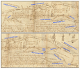
I think the resurvey map on this 1813 West Jersey record might have a Prestone (Pestleton?) Road. The NJ State Archive copy is hard to read—

TO: Benjamin B. Cooper (Esquire)
15 Oct 1813
FROM:
RESURVEY AND MAP. 4073 acres. South side of branch called Mechesatuxent; Wasses Branch; Prices Branch; Burnt Mill Branch; Coopers Branch; Bates Mill Road; Robert Bryants Road; Clem Dicksons Road; Pestone Road; in the Waterford Township and [left blank; possibly Gloucester Township]; Gloucester County. Resurveyed for 4,073 acres with exceptions; 1,296 acres, 39 perches overplus. [Warrant Date: 3 Nov 1812].
OTHERS NAMED: Benjamin Bate (Owner of adjoining land; [on Map]); Robert Bryant (Robt. Bryants Road; [on Map]); Constantine Champion (Chain Bearer); John Clement (Deputy Surveyor) (Signatory); Clement Dickson (Clem Dicksons Road; [on Map]); Martin Gibbs (and Others; Owners of adjoining land); Daniel Perry (Chain Bearer); [Unrecorded] Pestone ([Penstone Road ?]; [on Map]); [Unrecorded] Wasse (Wasses Branch; Wasses Line; [on Map])
LOCATIONS: West Jersey; Gloucester; Gloucester Township; Waterford Township; Burnt Mill Branch; Coopers Creek; Mechescatuxin; Mechescotuxing; Metchestauxing Branch; Prices Branch; Bates Mill Road; Mill Road; Roads, Streets, Highways, Paths
WJ Loose Records : 1813 - Cooper, Benjamin B. (OV-B) (54461) (PWESJ004)


Screenshot 2024-07-23 at 12.56.51 PM.png


Here's Sebastian Woas' house on this 1772 West Jersey record—

TO: John West (John West's saw mill; Also owner of adjoining land)
13 Oct 1772
FROM:
SURVEY AND MAP. 104 acres. Between two branches of Little Egg Harbor River called Nescacheage Creek and Machescatuason; On the South side of Goose Pond; Cedar Swamp; Gloucester County. [Warrant Date: 10 May 1771].
OTHERS NAMED: John Bispham (and Company; Owners of adjoining land); Thomas Causway (Owner of adjoining land); David Clark (Owner of adjoining land); Elijah Clark (Owner of adjoining land); Thomas Clark (Owner of adjoining land); [Unrecorded] Dimsdale (Dimsdale's old cedar swamp; Owner of adjoinging land); George Marpole (Owner of adjoining land); Daniel O'Nail (Owner of adjoining land); William Ridgway (Deputy Surveyor) (Signatory); Vincent West (Owner of adjoining land); Sebastian Woas (Sebastian Woas's house; Owner of adjoining land); Xaverius Woas (Owner of adjoining land)
LOCATIONS: West Jersey; Gloucester; Beaver Dam; Cedar Swamp; Swamps and Swampland; Goose Pond; Little Egg Harbor River; Matcheescotucksing; Nescocheag Creek; Dams; Houses, Buildings, Structures, Cabins; Mills; Mill Lots
WJ Loose Records : 1772 - West, John (42580) (PWESJ004)


I've transferred (in draft) the cursive to print for both documents. Email me and I will forward them.

S-M
 
  • Like
Reactions: Boyd

Piney Roots

New Member
Jul 22, 2024
14
24
Bainbridge Island, WA
I have another theory on the location of Shane's Castle taken from articles I have found or that were forwarded to me by Jerseyman.

In the meantime, here is a very cool 1885 map that I wish was reproduced more clearly. It should still be on file in Camden County Register of Deeds where I obtained it for boundary surveys that I have prepared in the Pestletown area.
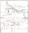
I have read all of Clement's articles on Shane's Castle (he published three that are essentially the same), and a lot of the details he provides are either provably inaccurate or unprovable and likely invented embellishments. In this particular article he implies that the Woos grave yard was on the opposite side of Clark Branch from Shane's Castle, which would place it where Waterford Memorial Park is today. I initially wanted to believe that, but further research raised significant doubts. Foremost among them is the fact that Sebastian Woos sold his 100 acres of land south of Clark Branch in 1797. Waterford Memorial Park is located in the upper northwest corner of that parcel. The 1797 deed makes no mention of a graveyard or an exemption for a graveyard, and it never made sense to me that Sebastian would sell the land containing the family burial ground where some of his children and grandchildren were likely buried, or where he and his wife probably intended to be buried. The land did not come back into the family until 1801 when Sebastian's son-in-law purchased it (this was Harmon Myrose, who married Catherine Woos). The first mention of the cemetery there is in Harmon's 1843 will. What led me to shift my focus to the graveyard in Lot 12 north of Clark Branch was the 1884 survey of Mary Neild's land attached below with my annotations added. This encompassed much of Sebastian's land north of Clark Branch, eventually bought by Sebastian's son-in-law Eli Neild and inherited by Mary after the death of her brother James about 1841. Interestingly, Clement contradicts himself in the article when he says the Woos cemetery was south of the branch since his notes say "the old grave yard is on the place now owned by Mary Nield in which is buried these first settlers.” Mary Neild never owned the land where Waterford Memorial Park is located, that was owned by the Myrose's and later became Joseph Garwood's farm in the late 19th century. I have digressed a bit from your original mention of the location of Shane's Castle. I show on the attachment where the 1761 survey, as well as the later survey posted above by Spung-Man, show it (north of Clark Branch and its cedar swamp, and, I would estimate, roughly 550 yards west of Pestleton Road).
 

Attachments

  • 1884 Survey.pdf
    1.5 MB · Views: 67

Piney Roots

New Member
Jul 22, 2024
14
24
Bainbridge Island, WA
I've only skimmed this tread, so apologize beforehand if this information is a repeat.

I think the resurvey map on this 1813 West Jersey record might have a Prestone (Pestleton?) Road. The NJ State Archive copy is hard to read—

TO: Benjamin B. Cooper (Esquire)
15 Oct 1813
FROM:
RESURVEY AND MAP. 4073 acres. South side of branch called Mechesatuxent; Wasses Branch; Prices Branch; Burnt Mill Branch; Coopers Branch; Bates Mill Road; Robert Bryants Road; Clem Dicksons Road; Pestone Road; in the Waterford Township and [left blank; possibly Gloucester Township]; Gloucester County. Resurveyed for 4,073 acres with exceptions; 1,296 acres, 39 perches overplus. [Warrant Date: 3 Nov 1812].
OTHERS NAMED: Benjamin Bate (Owner of adjoining land; [on Map]); Robert Bryant (Robt. Bryants Road; [on Map]); Constantine Champion (Chain Bearer); John Clement (Deputy Surveyor) (Signatory); Clement Dickson (Clem Dicksons Road; [on Map]); Martin Gibbs (and Others; Owners of adjoining land); Daniel Perry (Chain Bearer); [Unrecorded] Pestone ([Penstone Road ?]; [on Map]); [Unrecorded] Wasse (Wasses Branch; Wasses Line; [on Map])
LOCATIONS: West Jersey; Gloucester; Gloucester Township; Waterford Township; Burnt Mill Branch; Coopers Creek; Mechescatuxin; Mechescotuxing; Metchestauxing Branch; Prices Branch; Bates Mill Road; Mill Road; Roads, Streets, Highways, Paths
WJ Loose Records : 1813 - Cooper, Benjamin B. (OV-B) (54461) (PWESJ004)


Here's Sebastian Woas' house on this 1772 West Jersey record—

TO: John West (John West's saw mill; Also owner of adjoining land)
13 Oct 1772
FROM:
SURVEY AND MAP. 104 acres. Between two branches of Little Egg Harbor River called Nescacheage Creek and Machescatuason; On the South side of Goose Pond; Cedar Swamp; Gloucester County. [Warrant Date: 10 May 1771].
OTHERS NAMED: John Bispham (and Company; Owners of adjoining land); Thomas Causway (Owner of adjoining land); David Clark (Owner of adjoining land); Elijah Clark (Owner of adjoining land); Thomas Clark (Owner of adjoining land); [Unrecorded] Dimsdale (Dimsdale's old cedar swamp; Owner of adjoinging land); George Marpole (Owner of adjoining land); Daniel O'Nail (Owner of adjoining land); William Ridgway (Deputy Surveyor) (Signatory); Vincent West (Owner of adjoining land); Sebastian Woas (Sebastian Woas's house; Owner of adjoining land); Xaverius Woas (Owner of adjoining land)
LOCATIONS: West Jersey; Gloucester; Beaver Dam; Cedar Swamp; Swamps and Swampland; Goose Pond; Little Egg Harbor River; Matcheescotucksing; Nescocheag Creek; Dams; Houses, Buildings, Structures, Cabins; Mills; Mill Lots
WJ Loose Records : 1772 - West, John (42580) (PWESJ004)


I've transferred (in draft) the cursive to print for both documents. Email me and I will forward them.

S-M
Thanks S-M. I had not see these surveys. The first one shows Shane's Castle in the general location of where I thought it was. This is the only survey I know of, other than the 1761 original, that depicts the location of his house north of Clark Branch (or as this survey calls it O'Neils).
 
  • Like
Reactions: Spung-Man

Piney Roots

New Member
Jul 22, 2024
14
24
Bainbridge Island, WA
I have a couple of questions for those of you who are Pestletown locals:

1. Is the road officially called Pestleton Road or Pestletown Road? I have seen it listed both ways.

2. Is the New Jersey state historical marker for Shane's Castle still there. The NJ Historical Commission website says it was erected in 1964 "on south side of road 15' back from edge of road near Clark's Branch Stream." I have tried to find it on Google maps using the Street View feature without any luck.

Piney Roots
 
Top