Spotlight Article on Off-Roading

I'm thinking that the map they use for the beginning of the process should have every road, trail and firecut on it so they all can be included in the decision making.

I know that the firecut information doesn't exist yet, one of my Scout's Eagle Projects was fundraising for GPS systems and mapping miles of firebreaks just in Wharton, and he barely scratched the surface. Had a second Eagle Project map more of those firebreaks for the state park service. It would take dozens and dozens of them to do them all though, even just in Wharton.

Roads and trails should be easy enough to do though, there was already the older topo map that had that information for the roads, and there simply aren't that many trails out there to overlay.
 

Teegate

Administrator
Site Administrator
Sep 17, 2002
26,009
8,775
Were they asked to map them or did they come up with the idea? I would be interested in knowing that.
 

Boyd

Administrator
Staff member
Site Administrator
Jul 31, 2004
9,892
3,046
Ben's Branch, Stephen Creek
my Scout's Eagle Projects was fundraising for GPS systems and mapping miles of firebreaks just in Wharton, and he barely scratched the surface.

Can you elaborate on that? Why would you need to do something as tedious mapping firebreaks with gps receivers (unless just for the educational value to the scouts)? Can't firebreaks be easily seen on aerial imagery? The 2012 NJGIN imagery has a resolution of 1 foot per pixel and +/- 4 foot horizontal positional accuracy with 95% confidence. One person should be able to map all the firebreaks in a week using this imagery… I have done quite a lot of tracings from aerial imagery when making my own maps - including buildings as small as sheds.

About the best case for any consumer GPS device would be +/- 7 foot (2 meter) accuracy. There are survey grade units, costing thousands of dollars, that can do better… but do you need better than +/4 feet to map a firebreak?

Sorry if I'm missing something obvious here! :)
 

Teegate

Administrator
Site Administrator
Sep 17, 2002
26,009
8,775
My concern is the scouts are being used to map the firebreaks to also make a MAP of them. The state would then be able to tell motorcycle users where they also can and can't go as well as maybe other people. Until we hear back we can only speculate that my excessive suspicion of the motives this state has to push their communistic idea's at us.
 

smoke_jumper

Piney
Mar 5, 2012
1,613
1,177
Atco, NJ
If the DEP wanted that information all they would have do is tell the FFS to gather up the info for them. The FFS works under the DEP.
 

Teegate

Administrator
Site Administrator
Sep 17, 2002
26,009
8,775
I suspect you are correct. However, he said they are mapping them for the Park Service so the question still is did they ask the scouts or did the scouts decide to do this on their own and ask the state if they could???
 

tsqurd

Explorer
Jul 29, 2015
187
148
South Jersey
Maybe I'm remembering it wrong, but wasn't there a claim made, when the whole MAP thing started, that the Wharton Superintendent walked every road and trail in the forest, to develop the MAP?
 

Teegate

Administrator
Site Administrator
Sep 17, 2002
26,009
8,775
Maybe I'm remembering it wrong, but wasn't there a claim made, when the whole MAP thing started, that the Wharton Superintendent walked every road and trail in the forest, to develop the MAP?

Yes
 
The initial scout had asked Wharton if they had any projects, and this was one of the suggested projects. I wasn't the project coach for this project, so I'm not sure the exact reasoning behind it that was given for the purpose of the project, but to get through the approval process it would have had to be something more substantial than an educational experience for the scouts involved. I do recall that the GPS units acquired were quite a bit pricier than the one I had at the time, but I don't think they were thousands of dollars.

I checked back in the picture archive, the first project was carried out on April 2011 (the process would have likely started the end of 2010, as paperwork has to be drawn up and approved), the second was over that summer. We did not take part in any further projects of that nature after that, but others may have.
 
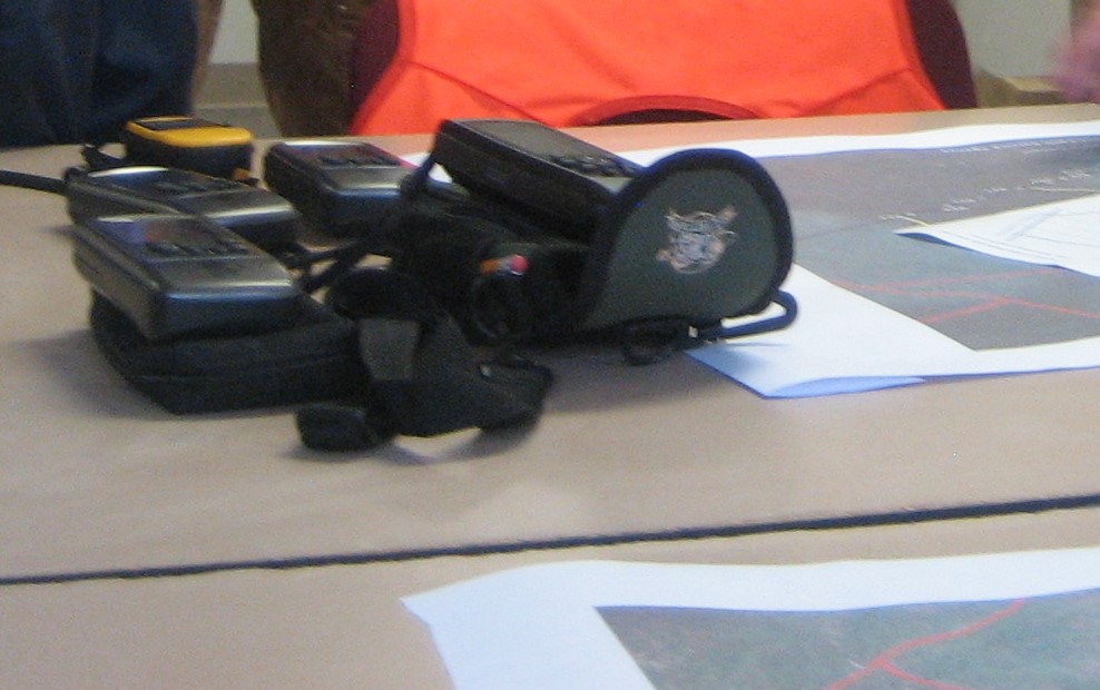
spring-2011-154.jpg


These might be the GPS units? From one of the project pictures.
 

Teegate

Administrator
Site Administrator
Sep 17, 2002
26,009
8,775
And either would I. Your post has been a real eye opener to me. Thanks Mike!
 

Broke Jeep Joe

Explorer
Mar 8, 2006
781
476
Waterford Twp
Can you elaborate on that? Why would you need to do something as tedious mapping firebreaks with gps receivers (unless just for the educational value to the scouts)? Can't firebreaks be easily seen on aerial imagery? The 2012 NJGIN imagery has a resolution of 1 foot per pixel and +/- 4 foot horizontal positional accuracy with 95% confidence. One person should be able to map all the firebreaks in a week using this imagery… I have done quite a lot of tracings from aerial imagery when making my own maps - including buildings as small as sheds.

About the best case for any consumer GPS device would be +/- 7 foot (2 meter) accuracy. There are survey grade units, costing thousands of dollars, that can do better… but do you need better than +/4 feet to map a firebreak?

Sorry if I'm missing something obvious here! :)

They most likely had them walk the hot spots to document damage first hand and threw in a few non hot spots to be inconspicuous. Wonder what other pics are in the archive Mike pulled the GPS pics from?
 

Piney4life

Explorer
Oct 8, 2015
381
128
52
Waterford
I think the numbers from 3 months compared to the previous 12 months of tickets shows the route the dep took is working. with the spp now having officers dedicated to wharton.no matter what you will always and forever have a few that will go where they dam well now know not too and that is just the world we live in.
 
They most likely had them walk the hot spots to document damage first hand and threw in a few non hot spots to be inconspicuous. Wonder what other pics are in the archive Mike pulled the GPS pics from?

They definitely weren't documenting damage at all, just walking up and down miles and miles of fire breaks. I remember a few complaining about having to walk it. The ironic part is that this particular Scout knowingly double booked his project with a backpacking trip on the Batona Trail, so the kids that weren't walking firebreaks were out backpacking 50 miles that week. I was actually heading up that one, so I didn't attend this particular project.

Rest of the pictures from that project (there are only 5) are the usual for a project - the scout telling everyone what to do, a few of the Scouts doing stuff, and a final shot with the whole group.

And the archive is the archive of pictures of our troop from the last 52 years. I never thought of it pine barrens-wise, but we do have pictures the Troop doing stuff out there (mostly camping and canoeing) with the earliest being from 1967.
 
  • Like
Reactions: Broke Jeep Joe

Broke Jeep Joe

Explorer
Mar 8, 2006
781
476
Waterford Twp
They definitely weren't documenting damage at all, just walking up and down miles and miles of fire breaks. I remember a few complaining about having to walk it. The ironic part is that this particular Scout knowingly double booked his project with a backpacking trip on the Batona Trail, so the kids that weren't walking firebreaks were out backpacking 50 miles that week. I was actually heading up that one, so I didn't attend this particular project.

Rest of the pictures from that project (there are only 5) are the usual for a project - the scout telling everyone what to do, a few of the Scouts doing stuff, and a final shot with the whole group.

And the archive is the archive of pictures of our troop from the last 52 years. I never thought of it pine barrens-wise, but we do have pictures the Troop doing stuff out there (mostly camping and canoeing) with the earliest being from 1967.

Thanks Mike!
 
Top