Boyd's Map of the Pines beta available

46er

Piney
Mar 24, 2004
8,837
2,143
Coastal NJ
Great 46er. Looks like you were posting that at the same time as I was writing my POI instructions above. Let me know how it goes if you install the custom POI file on your Nuvi.

I rarely use the POI's, but will give it a test. I stored your file on an SD card. For others doing the same, make sure you have a 'GARMIN' directory on the SD card into which you copy Boyd's file. Not sure about this, but I believe you will need to have the SD card to load Boyd's maps whenever you want to utilize them, they will not be in the NUVI's memory. As my NUVI is now setup, I have the City map & my custom TOPO2008 maps in memory, with Boyds maps on the SD card. Very convenient.
 

Boyd

Administrator
Staff member
Site Administrator
Jul 31, 2004
9,502
2,765
Ben's Branch, Stephen Creek
The simple rule for filenames is that you may have one gmapsupp.img file in the Garmin folder of your Nuvi's built-in memory, and a second gmapsupp.img file in the Garmin folder on an SD card.

But the reality is more complicated actually. Since you have a Nuvi 750 there are a lot of possibilities... if you want to thoroughly confuse yourself, read this: http://forums.gpsreview.net/viewtopic.php?t=10312

What you're doing is a good way to make all three maps available on your Nuvi though, which is what I have as well:

nuvimap.jpg


I am looking at different ways to make this work on the handheld units like the 60csx and hope to post a "howto" soon. Unfortunately they only have one form of memory and don't recognize different filenames, so a different trick will be needed.

Not sure about this, but I believe you will need to have the SD card to load Boyd's maps whenever you want to utilize them, they will not be in the NUVI's memory.

Actually, no. If you have a Nuvi and it only contains the original built-in City Navigator maps (if you haven't added any maps to it yourself), then you don't really need to use an SD card. You can just follow my instructions on page 1 and put the gmapsupp.img file in the Garmin directory of the Nuvi's internal memory.

In fact, some people might be using the pre-loaded SD card version of US Topo on their Nuvi. If so, then you CANNOT add the Map of the Pines to the card. DO NOT attempt to change anything on one of Garmin's pre-loaded cards! In this case, just use my instructions on the first page of this thread and load the map in the Nuvi's internal memory.
 

46er

Piney
Mar 24, 2004
8,837
2,143
Coastal NJ
Actually, no. If you have a Nuvi and it only contains the original built-in City Navigator maps (if you haven't added any maps to it yourself), then you don't really need to use an SD card.

That's good info. I think I'll switch and have your maps and the City maps in memory and my custom TOP2008 maps on the SD card as yours will get more use.
 

Boyd

Administrator
Staff member
Site Administrator
Jul 31, 2004
9,502
2,765
Ben's Branch, Stephen Creek
Interesting point there too... somewhere I read that internal memory can be accessed a little faster than the storage card. That is only anecdotal however.

But I think the storage card is probably a better place for the US Topo maps for another reason. Free space in the internal memory is usually somewhat limited. On your 750 it's probably something like 512MB or less? 2GB SD cards are pretty cheap now, and that would leave more room if you want to load a large section of US Topo. The Pines Map is small - only 25MB - and will easily fit in unused internal storage.

Now some people may also have MP3's, photos and other content loaded on their Nuvi's, and that would also need to be taken into account when looking at free space.
 

46er

Piney
Mar 24, 2004
8,837
2,143
Coastal NJ
Boyd,

I used the POI feature and the search feature on the NUVI and it showed a list of POI's and didn't crash, not sure which POI's are yours though.

A quick question; can I view your maps with Garmin's mapsource? Just make a copy of yours with the name used on the NUVI and open it in Mapsource or am I way off on this?

I need to get a serial converter plug to try the maps on the Vista, no serial port to use on my 'puter. I think Santa is bringing me one :rofl:

Thanks
 

Boyd

Administrator
Staff member
Site Administrator
Jul 31, 2004
9,502
2,765
Ben's Branch, Stephen Creek
Glad that you didn't get the crashes I was experiencing 46er. I guess there are some differences between the nuvi models.

There should be an easy way to get the map into mapsource, but I just haven't taken the time to figure it out. Will do this soon. In the meantime I suggest you use GPSMapEdit to view the map on your PC. You can also import/export your waypoints or tracks in that program (I think). With this first version I thought it might be best not to install in mapsource, since it's definitely a beta. You would then have to remove it later when the new version comes along.

The next release will have a new and greatly improved POI database. Guy (TeeGate) is editing and augmenting this now, so there will be lots of great new stuff and corrections. We also discovered there are a number of duplicate POI's. I made a stupid mistake and used some overlapping data, but the Census Bureau also seems to have a lot of duplicates in Atlantic County for some reason.

The next version will also be greatly improved visually, especially on the Nuvi. I am still learning the tricks of customizing the map appearance, but there's a lot which can be done. I used my newest version during this morning's commute and am pretty happy so far.

Two things have always bothered me about Garmin's maps on the Nuvi. First, the park areas are rendered in a very dark green which makes the roads hard to see. The new version has a pale green background which cures this. And any wetlands areas cover up the park outlines, making it hard to tell if a swamp is on private or public land. I have come up with a transparent background for the wetlands pattern which looks more like a USGS topo and doesn't obliterate the park areas. The cool thing is that you should also be able to apply these new styles to Garmin's own US Topo maps by adding a small config file to your existing mapsets. I will post some screenshots later.

I should have an update available sometime over the holidays.... more info to follow!
 

46er

Piney
Mar 24, 2004
8,837
2,143
Coastal NJ
Two things have always bothered me about Garmin's maps on the Nuvi. First, the park areas are rendered in a very dark green which makes the roads hard to see. The new version has a pale green background which cures this. And any wetlands areas cover up the park outlines, making it hard to tell if a swamp is on private or public land. I have come up with a transparent background for the wetlands pattern which looks more like a USGS topo and doesn't obliterate the park areas. The cool thing is that you should also be able to apply these new styles to Garmin's own US Topo maps by adding a small config file to your existing mapsets. I will post some screenshots later.

I should have an update available sometime over the holidays.... more info to follow!

I could not agree more with the color choices Garmin made, especially bad on a small screen. Thanks, looking forward to the updates.
 

Teegate

Administrator
Site Administrator
Sep 17, 2002
25,602
8,178
All,

If you haven’t installed Boyd’s topo’s I really want to suggest that you do. I checked them out again today and I have to say Boyd’s maps clearly put Garmin’s to shame. It is without a doubt one of the best free items you could ever use for exploring the pines. They are as much like a normal topo as you can get, and the shape files are amazing. Drive down Jackson road right at Atco Dragway and watch yourself on the GPS enter or leave Wharton. It is impressive! Or Carranza Road for that matter. So many times while in the middle of the woods all I would get with Garmin’s topo maps was absolutely nothing. Completely Blank! Well, that is almost impossible with Boyd’s Map of the Pines. If you haven’t installed them give them a try.

Boyd, I am really impressed! Well done!

Guy
 

Boyd

Administrator
Staff member
Site Administrator
Jul 31, 2004
9,502
2,765
Ben's Branch, Stephen Creek
Thanks for all the kind words Guy :)

I hope to have the next version available by New Years. It is a really major upgrade, so if you haven't downloaded yet and don't need the maps for a few more days you might want to wait. Of course there's no harm in installing the current version and replacing it later either.

The new version has significantly more data about the landscape, rendering it as either forest, swamp, forested wetlands, grasslands or cleared land. You will also see state forest, WMA and other public land boundaries plus a number of other visual improvements. Coming soon...

205-02.jpg

Version 34 on the Nuvi 205
 

Boyd

Administrator
Staff member
Site Administrator
Jul 31, 2004
9,502
2,765
Ben's Branch, Stephen Creek
Mapsource "hack"

A quick question; can I view your maps with Garmin's mapsource? Just make a copy of yours with the name used on the NUVI and open it in Mapsource or am I way off on this?

Getting back to this issue.... Unfortunately it's not this easy to open a file in MapSource. I have decided not to support MapSource at the current time. There seem to be a variety of issues involved with making proper files which will install in Mapsource. These relate to product codes, preview files and the Windows registry. I'm just not a Windows person - only use it for mapmaking - and am scared to mess with the registry! Then there would be the issue of needing to uninstall the maps and reinstall with each new version.

However... I have found a "hack" to install the map and it seems to work - sort of. I don't think there's much harm in this, but use it completely at your own risk. I can't support it myself. It should be pretty easy to remove if you don't like it.

Here's how. First, start Mapsource and look at the list of available maps using the dropdown menu. If you only have the topo maps then the list will probably only consist of them and "no map". If you see another listing for "PC basemap" then skip the following paragraph. Otherwise, here's how to download the PC basemap.

Garmin makes a program called "training center" which is somehow used with their sport GPS'es to plan workouts (never tried it myself). But it includes a very simple basemap file to display a map on your PC. If you download and install the program this file will be added to the dropdown map list when you run Mapsource. Download the program from this link and install: http://www8.garmin.com/support/collection.jsp?product=999-99999-04. Quit from the installer when it wants to install the USB drivers (they aren't needed).

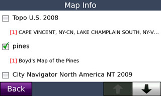
Now start MapSource and confirm that you have the PC Basemap option under the map dropdown menu. Quit from MapSource. Using Windows Explorer, navigate to the following folder: My Computer > Local Disk C: > Garmin > PCBSMP2. You will see a file named pc_basemap2.img. Rename this file something else - I called it pc_basemap2.old. Now copy the the Map of the Pines .img file (gmapsupp.img from your gps) to this folder and rename it pc_basemap2.img. Open mapsource again and choose the PC basemap - you will now be looking at the map of the pines. I found that it defaulted to the 1500 mile zoom level so I couldn't see anything. If this happens, switch the the Garmin topo map, zoom in to an area of interest, then select the PC basemap from the dropdown menu.

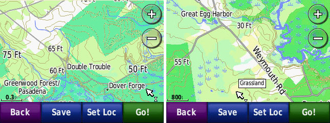
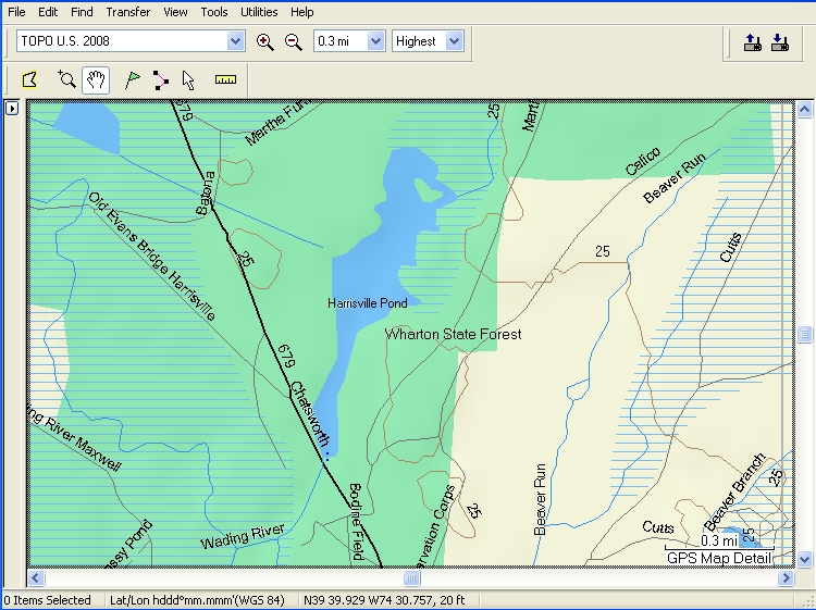
Now don't expect too much here. It will still look like an ugly Mapsource map, but it will have more detail than US Topo. Using my new version of the Map of the Pines, all of the special landcover features don't really work right (as expected). Also, for some reason it wasn't showing the whole map. Caveat Emptor! Like I said, I can't support this myself but feel free to experiment and share what you find. Here are a couple screenshots. It appears that the areas with the brown lines are the "forest" areas of my map.

garmin-mapsource.jpg

Garmin Map

pines-mapsource.jpg

Boyd's Map
 

Boyd

Administrator
Staff member
Site Administrator
Jul 31, 2004
9,502
2,765
Ben's Branch, Stephen Creek
FYI.... The new version of my maps are now ready and I have sent them to Ben to put online. Please be patient because I know he is busy with other things. I will post download instructions here ASAP.

In the meantime, if you have an expedition planned and would really like the new maps right away, send me a PM.
 

NJBill

Explorer
Sep 10, 2008
120
2
Hamilton (Mercer County)
Many thanks to Boyd for forwarding a copy of his most recent update and again being so generous with the time he spent developing this and for sharing it freely. To have something so valuable and for free just does not happen often and beside that, you could not even find anything like this out there!

I gave it a test ride today and will post the trip summary part in the proper forum.

This is a MUST have for anyone that owns a Nuvi. While the Nuvi has a somewhat decent database of some of the back roads, Boyd's maps are amazing! Being a relatively new Pines explorer I have relied up to this point on paper Topos the Nuvi and my old Magellan Sportrak Pro. Boyd's map had all the roads, nice topo detail, lots of locations of key interest areas on the screen and worked like a charm.

As mentioned previously the first released program had a “CAPS” version which I required with my NUVI 350 in order to see the names of the roads properly. The version I tested today did not have this and I'm sure Boyd will have (has) this available. Also, and I am just assuming that it is in or has something to do with the POI database, which is awesome to have and thanks to Guy for his additions, I was getting speed warnings on my NUVI screen at very unusual locations. It came on several times deep in the pines as well as on Rt72 stating “18MPH Speed Warning”. Again I'm just assuming it is something to do with the POI database since I had never seen this prior.


Thanks Boyd!

Bill
 

Teegate

Administrator
Site Administrator
Sep 17, 2002
25,602
8,178
Maybe Boyd added radar software to his maps :)

If you save you tracks and know how to edit them, you can pass them on to Boyd or me for the roads that are not shown on his maps. For example, on our hike yesterday we met at the Bordentown Gun Club on 532 and I parked my car at the corner there facing the road we were going down. I deleted all tracks and when Bob drove us down that road to Carranza I captured the tracks and edited them and passed them on to Boyd. He can now add the road to his maps. It is partially on there but now we should have the complete road.

bordentown_carranza.jpg


So basically clear your tracks and turn you GPS on right at the start of the road. Drive to the end and turn your GPS off. Download the tracks and Boyd has a road.

Guy
 

Boyd

Administrator
Staff member
Site Administrator
Jul 31, 2004
9,502
2,765
Ben's Branch, Stephen Creek
Interesting... I never saw the speed warning before. That could only come from the unit's basemap as there is no speed data in my map. Bill, since you said you had a nuvi I assumed you would want the nuvi version, forgot you have the older 350. Have you updated the firmware on your unit? I think the nuvi version should work correctly. Go to Garmin's website and get the WebUpdater software if you don't already have it. You should find it in the support section. You can use the version with all caps, but it doesn't have all the features of the nuvi version because it's tuned for the older 60csx.

[edit]The new version of the maps is now online here at NJPB, thanks to Guy. Please use the following links to download, the old links will no longer work.

Classic Version: Use for the GPSMap 60 and 76 series, eTrex series and any other older units which have smaller screens and can't properly display lowercase text. This version displays less information about the landscape so as not to overload the older GPS chips:

http://teegate.njpinebarrens.com/boydsmapsofthepines/PinesMap-classic.zip


Nuvi Version: Use this version for the Nuvi, Colorado and Oregon series. If in doubt, try this version first. If it doesn't provide acceptable performance, or if text isn't readable, switch to the Classic version:

http://teegate.njpinebarrens.com/boydsmapsofthepines/PinesMap-nuvi-1.zip


If downloading under windows, save the file on your computer then right-click and choose "extract all". If using a Mac, the files should automatically be extracted when the donwload is complete. Full documentation is included in the download. Follow these instructions and disregard the old instructions I posted here earlier.

Enjoy!
 

46er

Piney
Mar 24, 2004
8,837
2,143
Coastal NJ
Thanks Boyd!!!

Just a quick question; you are using the Garmin file name for this update, instead of your original file naming convention?
 

Boyd

Administrator
Staff member
Site Administrator
Jul 31, 2004
9,502
2,765
Ben's Branch, Stephen Creek
Yes, that just seemed easier to me. The instructions that are included have been updated to reflect this. Once we get the files online here, I will revise the earlier posts in this thread regarding installation.
 
Top