Boyd's Map of the Pines beta available

Boyd

Administrator
Staff member
Site Administrator
Jul 31, 2004
9,817
3,000
Ben's Branch, Stephen Creek
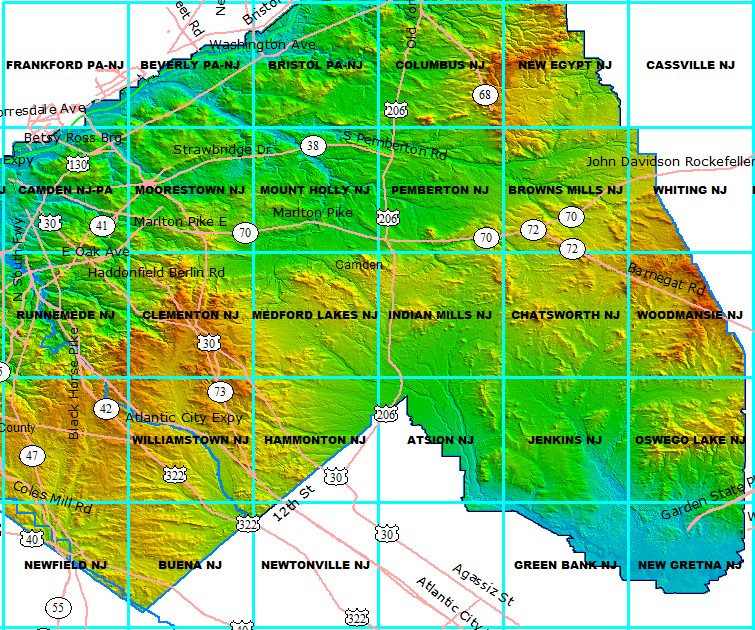
Bob, that's a good choice but unfortunately it isn't part of the LIDAR coverage. And there isn't much point in interpolating the low resolution DEM in 2 foot intervals. Sorry, I should have pointed out the limits of this data. Here's a map with some major roads and also the USGS quads. I can use different intervals for each quad.

Do you have a second choice? :)

pines_lidar.png


46er: I think one of the issues may be that Bob is looking at this as a tool for hiking across the landscape wherever he chooses. I definitely identify with that, but the artist in me just likes to stare at maps and wonder what the lines and dots represent. I also don't like zooming in and having a blank screen (like you will with Garmin's maps). :)
 

Boyd

Administrator
Staff member
Site Administrator
Jul 31, 2004
9,817
3,000
Ben's Branch, Stephen Creek
Yeah that's a good spot. I will also do a sample on a flat adjacent area, since that's the kind of place where you might find some bumps or holes that look interesting. :) LIDAR tends to make man's work stand out from nature.

I just got it setup on the computer, and will post something later this evening when I get back.
 

Boyd

Administrator
Staff member
Site Administrator
Jul 31, 2004
9,817
3,000
Ben's Branch, Stephen Creek
Well there's a lot here to digest. This first series of examples is shown at the native resolution of the USGS 24k topo maps (1:24000). Heh, sorry if this page is slow to load but I wanted to provide reasonable size samples for comparison. Each image shows the exact same area.

con01.PNG


con02.PNG


con03.PNG


con04.PNG
 

Boyd

Administrator
Staff member
Site Administrator
Jul 31, 2004
9,817
3,000
Ben's Branch, Stephen Creek
2 ft vs 5 ft contours at 300 foot zoom. I would say this is a scale I use more often when hiking around.

con15.PNG


con16.PNG


BTW, here's something interesting. Windows Vista wouldn't let me create a folder named "con". It said "invalid name".
 

bobpbx

Piney
Staff member
Oct 25, 2002
14,652
4,826
Pines; Bamber area
Thanks for the show!

It seals the deal for me. Two foot is ridiculous, 5 foot is just novel, and 10 foot makes the most sense in my opinion. It quickly helps the eye separate the true high areas from the surrounding area.
 

Boyd

Administrator
Staff member
Site Administrator
Jul 31, 2004
9,817
3,000
Ben's Branch, Stephen Creek
Now lets look at a flat area. Here's another set of 1:24000 images. The full range of elevations shown here lies between 24 and 37 meters - about 42 feet from lowest to highest point.

con18.PNG


con19.PNG


con21.PNG


con22.PNG
 

Boyd

Administrator
Staff member
Site Administrator
Jul 31, 2004
9,817
3,000
Ben's Branch, Stephen Creek
And at 500 feet...

con32.PNG


con33.PNG


Phew, that's it for the examples. Thanks for your reactions Bob. But I don't see myself going back to 10 foot intervals... there are other maps you can use if that's what you want. I would love to hear opinions on 2ft vs 5ft from more people... if anybody else has bothered to read this far. :D
 

Boyd

Administrator
Staff member
Site Administrator
Jul 31, 2004
9,817
3,000
Ben's Branch, Stephen Creek
Thanks! I am still torn between the two, but will need to decide pretty soon so I can finish up this new version.

Of course, it's a simple thing to put more than one map on the new GPS units and switch between the two. Bob, I wonder if you would really be happiest with the real USGS scans? I have posted these for most of the pines already, or Garmin's new Birdseye service will give you unlimited downloads for $30.
 

bobpbx

Piney
Staff member
Oct 25, 2002
14,652
4,826
Pines; Bamber area
Bob, I wonder if you would really be happiest with the real USGS scans?

Boyd, you may find this hard to believe, but it could be a blank screen (or all green) for all I care. I don't even own a working GPS right now. When it was working, I honestly never analyzed the terrain symbols. I have the waypoints in, and I just watch the tracking arrow. Before a trip I'll plan it on the computer using the photos in USA Photomaps...I'll print the photos out, and as I walk I'll use them for reference as to conditions ahead. I've gotten pretty good at reading the land ahead just by the way the light strikes off the vista, by what vegetation I can see, and the contrast on the photos that occurrs by vegetation type.

When I go out alone, I just 'look' at my spot of interest on the computer, then drive to the nearest road, get out of the truck and go. Do I get a little confused at times? Sure, but unless it is hot and humid out, I never worry too much...I still have that spatial sense of the location I'm in. Pine Barren roads are easily found if you know they are near and walk in a straight line.
 

Boyd

Administrator
Staff member
Site Administrator
Jul 31, 2004
9,817
3,000
Ben's Branch, Stephen Creek
Bob, you are definitely "old school"! :D I hiked around the pines for many years before getting a GPS and could still do if I wanted to. I would do things like wear shoes that made distinctive prints, then look for them when I backtracked home on the maze of little sand trails. Nothing wrong with any of that. I actually go into the pines quite a bit with no gps, no camera. I like to just get outside and experience things sometimes without messing around with gadgets. So I do "get" where you're coming from.

But I've been fascinated by maps since I was a small child. I like making maps with a lot of detail because they teach me something about the land in the process. And I can then enjoy the results when I take a GPS with me. I'd also like to think these maps will have some value for others and enhance their understanding and enjoyment.

Thanks for your thoughts on all this, but I think maybe you're just not "in the demo" for what I'm doing. It just doesn't make sense to get high quality data, then "dumb it down" into something that could have been made 40 years ago. So my question still stands, if anybody else is interested... are the 2 foot contours "too much information"?

Pan: thanks! But I don't know that my Garmin would appreciate my style. Heh, I think they may be closer to Bob's way of thinking. They seem to like a simple, uncluttered map screen. And aside from that, I would miss the pines if I had to move to Olathe, Kansas. :D
 

46er

Piney
Mar 24, 2004
8,837
2,144
Coastal NJ
Having been indoctrinated for 37 years working in IT :eek:, you can never have "too much information". You can always ignore what you don't want, but you cannot create what you do want :D
 
Top