Boyd's Map of the Pines beta available

Boyd

Administrator
Staff member
Site Administrator
Jul 31, 2004
9,502
2,765
Ben's Branch, Stephen Creek
Hey, my Map of the Pines has been chosen as one of a select few "editor's choice" maps at GPSFileDepot. :)

http://www.gpsfiledepot.com/maps/state/nj

I'm finishing up work on a new, larger map which covers the entire state of New Jersey and parts of neighboring states (including Philadelphia and New York City) with the same level of detail. It should be available at GPSFileDepot in a couple weeks and will be a rather large download.
 

46er

Piney
Mar 24, 2004
8,837
2,143
Coastal NJ
Hey, my Map of the Pines has been chosen as one of a select few "editor's choice" maps at GPSFileDepot. :)

I saw that indicator thingy on the site. Congratulations. I'm stll amazed how you can transform those maps, I certainly do not possess the patience. You should hook up with Natl Geo or Trails Illustrated to do a series for them. I'd be happy to test them out :D
 

Boyd

Administrator
Staff member
Site Administrator
Jul 31, 2004
9,502
2,765
Ben's Branch, Stephen Creek
Thanks! :)

It's very time-consuming to make these maps, but that's an addiction I'll just have to live with. It's also very rewarding to get out into the woods and put them to use, and it's nice to know that they help others enjoy their travels. Unfortunately, it's a big step to go from editor's choice with a free map to a job that pays real money...
 

Boyd

Administrator
Staff member
Site Administrator
Jul 31, 2004
9,502
2,765
Ben's Branch, Stephen Creek
Boyd's Map of New Jersey / GS Edition

My map of New Jersey is now ready for download at GPSFileDepot: http://www.gpsfiledepot.com/maps/view/294/

This map covers the whole state, with a fair sized chunk of Eastern Pennsylvania as well as portions of New York, Delaware and Maryland. It also serves as a replacement for my Map of the Pines. It has enhanced details in the area of the pines, including better land use shading and more points of interest.

After downloading from GPSFileDepot, run the installer and the map will be installed into MapSource. You will find tutorials at GPSFileDepot to assist with this if needed. When the install completes, start Mapsource and choose View > Switch to Product > Boyd's Map of NJ to view the maps.

I have also provided a Mac version of the New Jersey map. This is my first try at making a Mac-compatible version; you will need to download RoadTrip and MapInstall from Garmin's site to use this file on your Mac: http://www8.garmin.com/macosx/index.jsp. After installing these programs, double click the .gmapi file containing the Map of NJ and it will be installed in RoadTrip. If you try this, let me know how it works for you. The map looks fine in RoadTrip on my own Mac.

Enjoy, and feel free to leave feedback either here or over at GPSFileDepot.
 

Teegate

Administrator
Site Administrator
Sep 17, 2002
25,602
8,177
Boyd,

I downloaded and installed your map in my computer. A few comments.

If anyone has a Mac and installs it, you need to go to the top right of Garmin Road Trip and choose Boyds map. It took me a while to figure out why it was not working. I hate to say this Boyd but it refreshes really slow in my computer. I have the detail set in the middle and even when to the far left it is slow. I can't see how a GPS could display this at all when my computer has problems. I really like the map and if you just had the pines area maybe it would refresh faster.

I took a video of it so you can see it. The video is huge on the screen so open your browser window as far as you can. You can see me drag the window to the left and the hand stays closed. What the movie does not show is while the hand is closed the ball is spinning trying to move the map. When the hand opens the map will then move. This is in real-time. Give it time to load and look for the hand moving.


http://home.comcast.net/~teegate/Screen_Recording4.mov


Do you have any idea's on this?

Guy
 

Boyd

Administrator
Staff member
Site Administrator
Jul 31, 2004
9,502
2,765
Ben's Branch, Stephen Creek
Yeah Guy... the problem is that RoadTrip sucks. It is really slow on my Mac as well. And I mean really slow. Using it on my PC under Vista it's much, much more responsive. I have detail set to the maximum, am viewing the same area of the map at .3 mile zoom in a window that is the same size. Using the arrow keys to scroll the map, it flies by on the PC and it crawls on the Mac. The difference is huge - perhaps 10 times faster on the PC? My Mac is 2.4ghz Intel Core2 Duo, my PC is 2.8ghz Core2 Duo so that certainly doesn't account for the huge difference. In fact, my PC has the on-board intel video port instead of a dedicated display card like the Mac. Video performance is rated as pretty mediocre on this PC.

I see similarly poor performance on my Mac at .5 mile zoom (like your video). I had not used RoadTrip since it first came out, so I downloaded the newest version when making this file yesterday and was really not impressed. The reason I made the Mac version was to make the map accessible to more people for loading on their GPS'es. I agree it's pretty frustrating to try to use it in RoadTrip. The map also looks better in Mapsource than Roadtrip.

This is a highly detailed map which pushes Garmin's format, so it is going to be more sluggish than US Topo no matter what. But I find it acceptable on both my Windows machine and on the GPS itself. I have tried it on all the units in the screenshots (Oregon, Nuvi 5000, Nuvi 1350 and Nuvi 205). The Oregon is the speediest for zooming and panning the map. There's a little lag in scrolling the screen but it really isn't too bad - quite usable IMO. A smaller map area doesn't make any real difference since the map is loaded in segments on the GPS. My Map of the Pines has essentially the same level of detail and performs the same.

Detail setting won't change much until you zoom out a bit, and then things like contour lines will start to disappear. Because of the amount of detail and the way features are rendered, the map works best at zoom levels of .3 miles and closer.

I also just tried using the map in Garmin Basecamp (you need to download the Beta version or it won't work at all with 3rd party maps). That is kind of a strange program. Performance is better, but none of the lines on the map show! No roads, no contour lines. Ugh.

So it's nice that Garmin has finally provided Mac software, since there was nothing for many years, but it's pretty bad. If you can run Windows on your Mac, or on a dedicated machine, try the Mapsource version. You will be amazed at how much better it works. Unfortunately there isn't much I can do about this since the bottleneck is Garmin's Mac software. Sorry...
 

46er

Piney
Mar 24, 2004
8,837
2,143
Coastal NJ
Boyd, just tried the Windows download and received this message on each attempt at execution of the downloaded file. Idea's?

4395708118_961ffc8d8d_o.jpg
 

Boyd

Administrator
Staff member
Site Administrator
Jul 31, 2004
9,502
2,765
Ben's Branch, Stephen Creek
That's strange. I guess I would take it at its word though - the download may have gotten corrupted. I downloaded the file myself and installed it under Win XP which I have running on my Mac laptop and everything worked fine. I wonder if some kind of interference might be caused by anti-virus software? I have Trend Micro on both of my Windows machines.

I would try turning off the anti virus software first and see if that helps. If not, hopefully another download should do it. There have been 19 downloads so far and I haven't heard of any other problems. If you aren't able to get it working, I will try removing the copy from my laptop and downloading it again to see what happens. That error message is coming from the installer script itself.
 

46er

Piney
Mar 24, 2004
8,837
2,143
Coastal NJ
That's strange. I guess I would take it at its word though - the download may have gotten corrupted. I downloaded the file myself and installed it under Win XP which I have running on my Mac laptop and everything worked fine. I wonder if some kind of interference might be caused by anti-virus software? I have Trend Micro on both of my Windows machines.

I would try turning off the anti virus software first and see if that helps. If not, hopefully another download should do it. There have been 19 downloads so far and I haven't heard of any other problems. If you aren't able to get it working, I will try removing the copy from my laptop and downloading it again to see what happens. That error message is coming from the installer script itself.

I also use Trend. Will try a bit later and clean everything already downloaded out first. My wireless has been like a yoyo today, perhaps that had an effect.
 

46er

Piney
Mar 24, 2004
8,837
2,143
Coastal NJ
It had to be a wireless problem since the download is still running. It was done imuch quicker the other times I tried.

Worked fine!!! No issues.
 

NJBill

Explorer
Sep 10, 2008
120
2
Hamilton (Mercer County)
Awesome job Boyd. Loaded it on my Oregon 400t and took it for a test walk in the neighborhood this evening. One thing I had never been happy with is that the 400t was terrible as far as showing relative position to roads and certain bodies of water etc. Not something that was a big deal but always irked me even though Garmin acknowledges this. Your map was dead on as I walked this evening.

If it ever dries out, which I'm beginning to wonder if it ever will, I'll be anxious to get it down to the Pines and and up north by the Gap to futher enjoy and appreciate.

As I have shared with your previous maps, thank you so much for your time and generosity!

Bill
 

Boyd

Administrator
Staff member
Site Administrator
Jul 31, 2004
9,502
2,765
Ben's Branch, Stephen Creek
Updating this old thread....

It's going to be just a bit longer before this is finished, but I wanted to give everyone a sneak peek at my next generation map :). The detail level has increased so much that I was having performance issues, even on the fast newer devices. After some experimentation, it turns out that a standard USGS 7.5 minute quad is a more efficient tile size.

So I'm slicing and dicing the old map to correspond with USGS quads. It's a big job - the map has gone from 35 tiles to 313! But the payoff is that this new version works well on all Garmin units, even the older models - and I have also fixed the problems with text displaying incorrectly on the old units. The new tiles range in size from about 1 to 2 mb, so this map should work in older units with small amounts of internal memory.

In Mapsource you'll now see the familiar names for each quad you select, with coverage matching the corresponding paper maps. You can then choose as little or as much of the map as you would like to send to the GPS.

gs2012-01.png


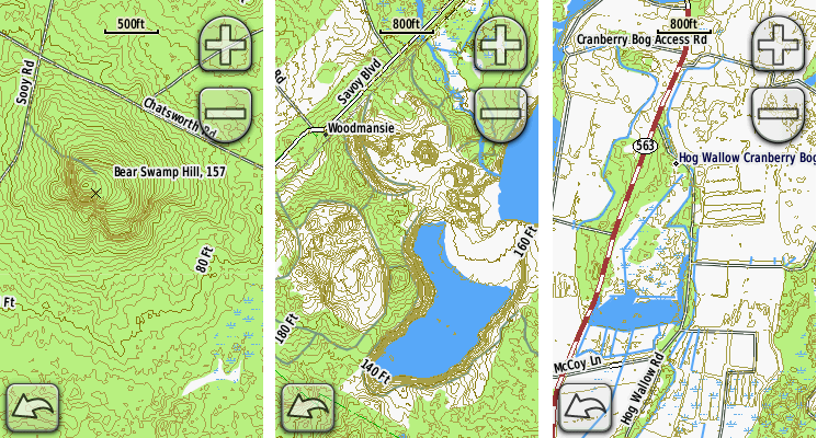
Here are some examples from the Oregon.

gs2012-02.png


I'm using the new LIDAR 1/9 arc second DEM (available in select areas) to create contour lines, and after a lot of experimentation, I like a 2 foot contour interval in many areas because it reveals a lot about the landscape. But I'd be interested in your comments - do you think it looks cluttered? Here's what it looks like on the 60csx.

gs2012-03.png


And on a Nuvi 205 - my goal has been to acheive consistent rendering across different Garmin models. My only frustation is that Mapsource just doesn't render maps the same as a GPS. So I can make it look good in either Mapsource or the GPS, but not both. :bang: I don't have a good solution for this (I guess I could do two versions), so I am opting to make it look good on the GPS. If you use an older version of Mapsource, or Garmin's free nRoute program, then it will look good on your computer. I guess this is "progress"?

gs2012-04.png


I'll post here when it's ready to download. If anyone would like to beta test this on their GPS, let me know. I could make a small map (a couple quads) available for download if there's interest.
 

Boyd

Administrator
Staff member
Site Administrator
Jul 31, 2004
9,502
2,765
Ben's Branch, Stephen Creek
For the purposes of comparison, the upper half of this image was created from the LIDAR data with a 2 foot contour interval and the bottom half uses the same data with a 5 foot interval. This screenshot is the equivalent of the 800 foot zoom scale on your GPS. Do you find the additional detail useful?

gs2012-05.png
 

bobpbx

Piney
Staff member
Oct 25, 2002
14,153
4,257
Pines; Bamber area
Boyd, I think that no, the 2 foot interval would not be useful. I notice that it calls a lot more land swamp, and that may cause uneeded confusion. Also, if you look at the contour lines in the upper one, the miniscule change in elevation is so far apart, that you would not even notice it, or even care. People who do serious exploring plot a course indicating the major changes...a lake, a creek, a spung, a cedar swamp, an abrupt elevation change that is considerable....and these are already clearly defined on the lower map.

And, if you don't do serious exploration, there would be no point to that fine detail anyway.
 

46er

Piney
Mar 24, 2004
8,837
2,143
Coastal NJ
Do you find the additional detail useful?

I don't think it looks cluttered at all, it more accurately shows the area. As many folks with varying interests will potentially be downloading this, I'd say the more detail the better.
 

Boyd

Administrator
Staff member
Site Administrator
Jul 31, 2004
9,502
2,765
Ben's Branch, Stephen Creek
Thanks Bob, those are very good points. Do you feel that the 5' interval is a good choice? I think the USGS uses 10' intervals and they show virtually nothing in an area like this. A lot of the extra detail in the 2' contours is just "noise", and that was my concerns. However there might be benefits in showing small depressions (cellar holes?) in certain areas.

However you are misinterpreting the swamp issue I think. The contour lines are a completely separate element and have no relation to the processing of hydrology and landcover. The wetland symbols on the map above are a combination of data from the USGS NHD (National Hydrology Database) and landcover data from NJGS. It does look a bit like it changes in the middle of the map, but I think that's coincidental. Here's the same spot on the USGS 24k map for comparison - the white line is the boundary between quads, same as my screenshot: http://maps.njpinebarrens.com/#lat=39.74941719408893&lng=-74.70207452774048&z=16&type=topo&gpx=

If somebody would like to suggest some specific locations (you could just link to NJPB maps), I will post a series of different contour versions along with the source LIDAR image. In addition to interval there are a number of other parameters that can be tweaked, such as sample spacing, curve smoothing and data interpolation.

The LIDAR data is a new thing and is really different from what we've had to work with before. The previous standard was 1/3 arc second DEM that was evidently hand-coded by overlaying a grid on paper topo maps. They then manually entered the elevation at each gridline intersection based on elevation contours on the paper map. This older DEM produces contours that I would call more "conceptual" than real. LIDAR is an actual scan of the terrain. I can sample it at larger intervals and smooth it to look more like the traditional contours we all know and love. But then I would be throwing away a lot of the detail in the data.

The small intervals don't work well in developed areas, because they tend to make buildings look like steep little hills. :)
 

bobpbx

Piney
Staff member
Oct 25, 2002
14,153
4,257
Pines; Bamber area
Boyd, yes, I think 5 is better. And yes, the 2' intervals are just noise. Regarding the wetlands, you may have a point, but that is not a good example due to the split in the map. Let me pick a spot for better analysis that I know....maybe tonite.
 
Top