I"ve always thought she does quite well.She doesn't fall anymore then I do and cusses a lot less when she does. I always think she's wore out at the end of a hike till we approach the vehicles,then she burns my old ass and gets there five minutes ahead of us.

Fall/Winter Stone Searching 2019/2020
- Thread starter Teegate
- Start date
You are using an out of date browser. It may not display this or other websites correctly.
You should upgrade or use an alternative browser.
You should upgrade or use an alternative browser.

All,
Slightly chilly this morning when we headed out to search for a few stones with a little history.
The Jones Mill Tract which consisted of about 10,000 acres ran from downtown Chatsworth at 563 and 532, down the Central Railroad across 72 to Rogers Road just before Woodmansie, then across portions of the Greenwood Forest to Union Clay Works, where it made a sharp turn and went all the way to Long Causeway before heading to Dukes Bridge and Jones Mill and on to downtown Chatsworth back at the beginning.
On February 7 1860 a reader of the Monmouth Democrat wrote in saying the property was owned by Thomas P. Barkalow a prominent hotel keeper and ran stage coach lines between Manahawken and Freehold as early as 1846. The writer also mentioned Barkalow had just sold the Jones Mill Tract to Beers and Chetwood. I have a huge map showing the survey of the outer perimeter of the Jones Mill Tract dated July 24, 1919 which tells us that "Beers Reality" still owned the property. Here is that map laying on my bed.

As I only had the outer perimeter map I did not know that the property had at least a few in-holdings inside of the perimeter, and today we went looking for the corners. My first clue was this line in an old deed.
Beginning at two old stones being the seventh course of the original survey, conveyed by Abraham Jones and wife to Annie Lippincott.
With a little research I was able to narrow the location down and we headed out to the Sykes Branch to find the two stones. We walked to the causeway and proceeded north in the direction my guesses took us.
At the causeway.

After walking a mile we arrived and started looking. It was a semi open area where I could fairly easily poke around and search. This proved to be imperative as when I located it the stone was completely underground. Yes, there was only one stone. Some time in the past one disappeared.
On the Jones Mill Tract

The view from that location.

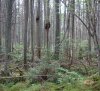
While in the area we explored a really nice cedar swamp.

Returning to the car we traveled 5 miles to get to the other side of the swamp where we looked for this stone from the deed.
Along the line of lot 6, North 85 degrees West, 38 chains and 84 links to a stake, 5 links South of an old stone corner in the line of the Jones Mill Tract.
We were able to drive close to this location and with a short walk in the woods we arrived. To our surprise there were three stones there. At first I though two of them were one broken in half, but they were both solid in the ground and I believe there is a total of three.
Along the line of the Jones Mill Tract.

Slightly chilly this morning when we headed out to search for a few stones with a little history.
The Jones Mill Tract which consisted of about 10,000 acres ran from downtown Chatsworth at 563 and 532, down the Central Railroad across 72 to Rogers Road just before Woodmansie, then across portions of the Greenwood Forest to Union Clay Works, where it made a sharp turn and went all the way to Long Causeway before heading to Dukes Bridge and Jones Mill and on to downtown Chatsworth back at the beginning.
On February 7 1860 a reader of the Monmouth Democrat wrote in saying the property was owned by Thomas P. Barkalow a prominent hotel keeper and ran stage coach lines between Manahawken and Freehold as early as 1846. The writer also mentioned Barkalow had just sold the Jones Mill Tract to Beers and Chetwood. I have a huge map showing the survey of the outer perimeter of the Jones Mill Tract dated July 24, 1919 which tells us that "Beers Reality" still owned the property. Here is that map laying on my bed.
As I only had the outer perimeter map I did not know that the property had at least a few in-holdings inside of the perimeter, and today we went looking for the corners. My first clue was this line in an old deed.
Beginning at two old stones being the seventh course of the original survey, conveyed by Abraham Jones and wife to Annie Lippincott.
With a little research I was able to narrow the location down and we headed out to the Sykes Branch to find the two stones. We walked to the causeway and proceeded north in the direction my guesses took us.
At the causeway.
After walking a mile we arrived and started looking. It was a semi open area where I could fairly easily poke around and search. This proved to be imperative as when I located it the stone was completely underground. Yes, there was only one stone. Some time in the past one disappeared.
On the Jones Mill Tract
The view from that location.
While in the area we explored a really nice cedar swamp.
Returning to the car we traveled 5 miles to get to the other side of the swamp where we looked for this stone from the deed.
Along the line of lot 6, North 85 degrees West, 38 chains and 84 links to a stake, 5 links South of an old stone corner in the line of the Jones Mill Tract.
We were able to drive close to this location and with a short walk in the woods we arrived. To our surprise there were three stones there. At first I though two of them were one broken in half, but they were both solid in the ground and I believe there is a total of three.
Along the line of the Jones Mill Tract.
That's a hell of a big tract of land.
Many are/were bigger. I will have to type up a semi long article tomorrow which tells us more about them.
This morning we returned to the area that we found the Jones Mill stones because I had reason to believe we would find more. We started searching and eventually found two stones next to each other on what I believe to be the Jones Mill line.. They are in a burned area making them much easier to see.

With one more location to look we walked an old road that was closing in even though it had been burned. Arriving where I felt it would be Jessica soon found it about 60 feet from my calculations. I also believe this was on the Jones Mill line.


We then headed to 72 and while walking to our next destination we came upon a melted boat. It even included the motor. In the end we did not find anything else.

While walking to the boat we came upon one of the test wells that the lock had been left open. I removed the cap and looked inside. Once done, I locked it up.

It appears they screw on an air line and force water up the plastic tube.

From there we headed to this pond off of Sooy Road near Bear Swamp Hill. The tax maps tell us it is owned by Joseph Gardiner but that is old news. It actually is almost in it's entirety owned by Pine Island Cranberry. One of the state corners is in the pond so you legally can access the edge of the pond at a specific spot when it is full. When it is not you are trespassing.

We found three of the corners. This is one of them with the remains of about 4 previous monuments over the years. No stones.

Then across 72 to the Union Clay Works area looking for a stone I searched for 15 years ago. Again, nothing. On the way we found a furnace. A boat and a furnace on the same day. The pines always amaze me!

Video soon.
With one more location to look we walked an old road that was closing in even though it had been burned. Arriving where I felt it would be Jessica soon found it about 60 feet from my calculations. I also believe this was on the Jones Mill line.
We then headed to 72 and while walking to our next destination we came upon a melted boat. It even included the motor. In the end we did not find anything else.
While walking to the boat we came upon one of the test wells that the lock had been left open. I removed the cap and looked inside. Once done, I locked it up.
It appears they screw on an air line and force water up the plastic tube.
From there we headed to this pond off of Sooy Road near Bear Swamp Hill. The tax maps tell us it is owned by Joseph Gardiner but that is old news. It actually is almost in it's entirety owned by Pine Island Cranberry. One of the state corners is in the pond so you legally can access the edge of the pond at a specific spot when it is full. When it is not you are trespassing.
We found three of the corners. This is one of them with the remains of about 4 previous monuments over the years. No stones.
Then across 72 to the Union Clay Works area looking for a stone I searched for 15 years ago. Again, nothing. On the way we found a furnace. A boat and a furnace on the same day. The pines always amaze me!
Video soon.
While driving up Sooy Road many vehicle drove by in a caravan. One stopped and told us to stay to the edges ahead. When arriving at this one we noticed wood and metal on the right far side. So Jessica got out to check the left side.
Interesting property corner. The state owns the side I am on and the other side is "unknown."

Looking at the 1963 to 1972 aerials there was a gun club there. The logs used in what appear to be the parking area are still there. That is pretty recent in reality and someone must know what that place was called.

It was located here.
I walked completely around that bog and across it on the north end and that was a real challenge. The east side is a nightmare with no path of any kind. I had to bail out on my destination and head to easier walking.

Ran into this.

Looking at the 1963 to 1972 aerials there was a gun club there. The logs used in what appear to be the parking area are still there. That is pretty recent in reality and someone must know what that place was called.
It was located here.
I walked completely around that bog and across it on the north end and that was a real challenge. The east side is a nightmare with no path of any kind. I had to bail out on my destination and head to easier walking.
Ran into this.
That is the swamp with a dump in it. It may be the remains of the gun club that was there as well as other trash.

I have learned a little more about some of the stones mentioned and shown above. For example this stone and the others I found the same day..

The property was owned by Abraham Jones of Jones Mills who also used the initial I (Eye) for his last name of J. His stones had an A (Eye) inscribed on them. There were at least 2 AI (Not AL) stones in this area near the Shoal Branch with one now missing and one currently under the paved road road right here at the beginning of Baptist Road but in the center of Chatsworth Tuckerton Road.
Anyway, the property and the stone above, owned by Abraham Jones, was sold by Jones to Arnie Lippincott on February 25, 1797. Arnie Lippincott was the grandfather of James Lippincott who eventually died as we all do, and the property was divided and sold to benefit his heirs. The stone above was on the Jones Mill corner and not one of the divided portions so it most likely dates to the mid 1700s.
We were out yesterday along the Shoal Branch and about 20 feet onto state property adjacent to Haines property we found this stream height gauge, most likely placed there because of the chemical dump nearby. The water was a little low.

This stone is again I believe on the Jones Mill line. Unfortuanly, being underground, in water, it is falling apart.

This stone is again I believe on the Jones Mill line. Unfortuanly, being underground, in water, it is falling apart.
That corner property is state and Haines, and Haines had it surveyed about 5 years ago I believe. There was an old wooden stake still partially standing so we found it without a problem.
You may have noticed on a tax map that there is a paper development along route 72 surrounding and including Barnegat Wreckers. The truth is there actually are many owners of those lots in the development called "Barnegat Heights" with Gun clubs and individuals from outside our area to name a few.

I was curious about the development and with a little research I came up with this. The property was owned by a company named the "Monte Development Corp.", and in 1927, and maybe 1926, they hired Surveyor Roy T. Havens from Point Pleasant Beach to plan it out and survey it. On February 25, 1927 he filed the Barnegat Heights plan with the Ocean County clerks office.
The Monte Development Corp. was incorporated in 1925 and at the time was located at 921 Bergen Ave in Jersey City. It was mentioned they were involved with "Real Estate, builders, contractors, etc." By 1927 they were located at 303 Fifth Ave in New York City.
So what were they going to do with the development and how did people find about the lots? I am unsure with this particular development; however, if they did the same thing at Barnegat Heights as they did with a paper development in Brick Township we have a pretty good idea how that occurred.
In November of 1926 this ad appeared in the Bergen Evening Record. See if you can solve the puzzle")
SOLVE THIS PUZZLE
L O V E R O T E S
The above letters when properly arranged spell the name of a late president.
Everyone sending in the correct solution will be awarded a beautiful building lot, size 20x100 feet, FREE AND CLEAR OF ALL ENCUMBRANCES, in our New Jersey development, between New York and Atlantic City. This offer expires November 28, 1926.
MONTE DEVELOPMENT CORP.
303 Fifth Avenue, New York City, Dept. 11-F
Again, the above is most likely Brick Township and not Barnegat Heights.
So today, Jessica and I decided to look for one of the corners of that development and to do that we had to push through the scrub pines along 72 to get there. That was a real struggle until we came to a motorcycle trail and then it was easy going. A short walk down the trail and we started looking. We were just about to give up when .........

I was curious about the development and with a little research I came up with this. The property was owned by a company named the "Monte Development Corp.", and in 1927, and maybe 1926, they hired Surveyor Roy T. Havens from Point Pleasant Beach to plan it out and survey it. On February 25, 1927 he filed the Barnegat Heights plan with the Ocean County clerks office.
The Monte Development Corp. was incorporated in 1925 and at the time was located at 921 Bergen Ave in Jersey City. It was mentioned they were involved with "Real Estate, builders, contractors, etc." By 1927 they were located at 303 Fifth Ave in New York City.
So what were they going to do with the development and how did people find about the lots? I am unsure with this particular development; however, if they did the same thing at Barnegat Heights as they did with a paper development in Brick Township we have a pretty good idea how that occurred.
In November of 1926 this ad appeared in the Bergen Evening Record. See if you can solve the puzzle
SOLVE THIS PUZZLE
L O V E R O T E S
The above letters when properly arranged spell the name of a late president.
Everyone sending in the correct solution will be awarded a beautiful building lot, size 20x100 feet, FREE AND CLEAR OF ALL ENCUMBRANCES, in our New Jersey development, between New York and Atlantic City. This offer expires November 28, 1926.
MONTE DEVELOPMENT CORP.
303 Fifth Avenue, New York City, Dept. 11-F
Again, the above is most likely Brick Township and not Barnegat Heights.
So today, Jessica and I decided to look for one of the corners of that development and to do that we had to push through the scrub pines along 72 to get there. That was a real struggle until we came to a motorcycle trail and then it was easy going. A short walk down the trail and we started looking. We were just about to give up when .........
That would be Roosevelt.
You have won a 20x100 lot in Barnegat Heights!
I know that trail. 20x100 is not enough to build a house, was the free lot a gimmick to winners to purchase adjoining lots to make a buildable lot? There were many proposed developments in the Pines that fortunately never happened. There is another one a short way East on 72 by Skippers seafood. I wonder if folks still pay the taxes?
I would suspect you are correct about them wanting you to buy adjacent lots, and then having them build a house.
While on that trail I noticed someone had been cutting branches and I actually mentioned you to Jessica. So we were talking about you yesterday
Some must still pay because there are quite a few owners in there. The state and township also own many so they may be the individuals who didn't pay. There is information available that I don't have concerning the Barnegat wreckers property being vacated to Applegate who first started the gas station years ago. Then it was Hennicker's which I have a photo of that I have never posted. I will save that for the book
We will be going back as there may be stones in the area or close by that I want to search for.
I haven't been there in maybe 4or 5 years so it's not me.While on that trail I noticed someone had been cutting branches and I actually mentioned you to Jessica. So we were talking about you yesterday