Guy, here is a companion monument to yours, location 74 43 16.6 39 44 30.4 If yours is #395 this is #393, hard to read. There was never private land in this area. It was Joseph Wharton's Peanut Field and always part of the Atsion Property. They must be on a traverse line or control points or both. Maybe rednekf350 or someone else has some idea? If it is a traverse line to get to the private exemptions in the village maybe there is another monument down by the river? Never saw one down there. If you are going to look down by the river, good luck the briers are so thick you can't even see through them.


Forest Fire at Atsion
- Thread starter ecampbell
- Start date
You are using an out of date browser. It may not display this or other websites correctly.
You should upgrade or use an alternative browser.
You should upgrade or use an alternative browser.
I guess fire is good for asparagus. This was in a burned out area standing almost 3 ft tall.

Panning for gold along the Wesickaman.

This little guy didn't make it.

Making a come back.

Also coming back.

Panning for gold along the Wesickaman.
This little guy didn't make it.
Making a come back.
Also coming back.

Don you are definitely insaneI made a walking stick out of a Poison Ivy vine I found growing up a tree. May still have it somewhere.
") ....Cool!
....Cool!Thanks Don. I would assume there is another one in between them numbered 394.
Asparagus grows almost anywhere. When I was a kid in the single digits, my grandfather would walk with me down 295 in Repaupo by his house and would pull out his pen knife constantly cutting it. When I stayed overnight I can remember them cooking it for dinner. I never see it along there anymore. It was all farms back then.
Asparagus grows almost anywhere. When I was a kid in the single digits, my grandfather would walk with me down 295 in Repaupo by his house and would pull out his pen knife constantly cutting it. When I stayed overnight I can remember them cooking it for dinner. I never see it along there anymore. It was all farms back then.
Don you are definitely insane
Yea, I liked the looks of it, so I cut it down, skinned it and pushed it into a 3" PVC pipe so it would dry fairly straight. I was going to carve it into a snake, but never did. Another project in the garage waiting to happen.
Thanks Don. I would assume there is another one in between them numbered 394.
Asparagus grows almost anywhere. When I was a kid in the single digits, my grandfather would walk with me down 295 in Repaupo by his house and would pull out his pen knife constantly cutting it. When I stayed overnight I can remember them cooking it for dinner. I never see it along there anymore. It was all farms back then.
I didn't find a monument between them, they are only about 450' apart.
Asparagus was a big crop in the Swedesboro area back in those days. They built Route 295 right through the asparagus fields. When they did they left all the infields of the ramps undisturbed, just tilled them and planted grass. For years the infields were full of asparagus. Even when they stripped and reused the topsoil in the slopes it was also full of asparagus. I used to go down every year to cut asparagus on the 295 right of way. This was in the early 70s. Still have my asparagus cutter. Tomato and asparagus fields are gone now in that area.
Thanks Don. I would assume there is another one in between them numbered 394.
Asparagus grows almost anywhere. When I was a kid in the single digits, my grandfather would walk with me down 295 in Repaupo by his house and would pull out his pen knife constantly cutting it. When I stayed overnight I can remember them cooking it for dinner. I never see it along there anymore. It was all farms back then.
Number 394, it was right in the middle. Now where is 392, 391, etc. and where is 395. Also guy the church was laid out in 1828, now would be the time to look for corner stones if interested
Number 394, it was right in the middle. Now where is 392, 391, etc. and where is 395. Also guy the church was laid out in 1828, now would be the time to look for corner stones if interested
View attachment 5760
Thanks for the find Don. I will get there this weekend. I have all the info on the church corners so I will also get there. I have to calculate them first which I will work on soon. There was a stone at the corner by the driveway but I doubt it is there.
All,
Don Catts asked me to check into the property corners of the church at Atsion and today Jessica and I did just that. The property lines are exactly 191 feet on all four sides so it was not too much trouble to look for them. I was able to find one of the corners.

I spent quite a bit of time getting a good GPS reading and after coming home I was able to determine exactly where the other corners are. Since I looked at all of them except the one by the church itself I am fairly certain the two eastern most monuments are no longer there. If you want to check on them yourself I have a little gift for you if you use Google Earth.
The download will start right away. Make sure you have Google Earth.
http://teegate.njpinebarrens.com/05232015/Atsion Church.zip
We found the Asparagus Don found recently. It is now taller than Jessica.

We also today looked for a few monuments for the Fruitland property. These monuments I am certain have not been viewed for many many years.


As for the mystery monuments they are still a mystery. I was not able to find anymore. I will continue to look.
Guy
Don Catts asked me to check into the property corners of the church at Atsion and today Jessica and I did just that. The property lines are exactly 191 feet on all four sides so it was not too much trouble to look for them. I was able to find one of the corners.
I spent quite a bit of time getting a good GPS reading and after coming home I was able to determine exactly where the other corners are. Since I looked at all of them except the one by the church itself I am fairly certain the two eastern most monuments are no longer there. If you want to check on them yourself I have a little gift for you if you use Google Earth.
The download will start right away. Make sure you have Google Earth.
http://teegate.njpinebarrens.com/05232015/Atsion Church.zip
We found the Asparagus Don found recently. It is now taller than Jessica.
We also today looked for a few monuments for the Fruitland property. These monuments I am certain have not been viewed for many many years.
As for the mystery monuments they are still a mystery. I was not able to find anymore. I will continue to look.
Guy
Guy and Jessica,
thanks for taking a peek at the church property. Looks like folks driving around the cemetery knocked out the two on the east side. They say the cemetery is full. I wonder if they know of the area behind the church.
The mystery monuments are not a mystery any more. I saw it on the history channel. It was ancient aliens, the monuments of Atsion align with the third star in Orion's belt forming a perfect triangle with the pyramids of Egypt. Just kidding of course, although they do glow in the dark at full moon.
The monuments do not have NJ or any other letters on them which leads me to believe they are not part of the Wharton Tract property survey, but maybe one was an important control point for the survey. The other two would tie it off so if it was knocked out the other two could be used to reset it. Just a wild guess. This is 1955 surveying methods, I'm sure the methods have changed since then.
Another guess that may mean something, is monument #395 on the northern right-of-way of Quaker Bridge Road? Could be, the road is 66 feet wide.
Also, the monuments at fruitland are interesting, does this mean there were private lots in this area in 1954-55 that we don't know about?
Don
Last edited:
All,
I was in Atsion before 6AM and checked out the corner right by the church itself and there is nothing there. So the only monument if the far back corner. I also traveled along the tracks all the way to the back of the Sewell Gun Club by the shooting range and can tell you the fire did make it onto their property. I looked for a stone at their property corner but was unable to find it. That is another Fruitland stone that I can't find. The fire reached to within about 50 feet of it or the area would have been all burned making it easier. The fire is still burning even today back there on the road in.
In one day the burned area behind the church has really changed. Look what happened.
The monuments do not have NJ or any other letters on them which leads me to believe they are not part of the Wharton Tract property survey, but maybe one was an important control point for the survey. The other two would tie it off so if it was knocked out the other two could be used to reset it. Just a wild guess. This is 1955 surveying methods, I'm sure the methods have changed since then.
Another guess that may mean something, is monument #395 on the northern right-of-way of Quaker Bridge Road? Could be, the road is 66 feet wide.
Also, the monuments at fruitland are interesting, does this mean there were private lots in this area in 1954-55 that we don't know about?
Don
The chuch and the three lots acorss Quaker Bridge Road are the only lots I have ever viewed in Wharton where the full information is not available to me. This could mean they did use those monuments to maybe tie into the Triangulation Station on the hill along 206. But I have no inforamtion saying they did and I have confidince I would have that info it it was true. So I have to say they are unrelated to the Wharton survey but may have been put there at a later date by someone surveying the lots such as a private contractor. Say for example the owners of the lots at the time had concerns about the accuracy of the Wharton survey and asked to have a second look. Then I would not have that info. Just a wild guess.
I am pretty confident the Wharton team surveyed the lines of Fruitland which can be viewed on the map you posted. They must have had to do that in order to properly survey the private lots. I really wish I knew more.
Jessica researched the Asparagus and she said it is wild Asparagus.
Those monuments really are a mystery they have to be state monuments. But we learn a little more each time, so maybe some day. Thanks Jessica for the info.
Another mystery in the area!
There are the remains of an old road at Atsion just west of the railroad tracks and heading north. I believe this was the original road from Atsion to Hampton Furnace. It may not be, it may be just an old logging road. However, on the Town of Raleigh layout plot it is called Hampton Avenue. It looks like the town was laid out around the old road as QBR was, there are just too many angles and change of directions to be a proposed avenue in a town. I always had it in my mind to check it out if the area ever burned out. Wednesday I followed it to the end of the burned area then it was just too thick to continue. The road was well used and cut into the ground pretty good, with many old bottles and cans dumped along the way.
The Raleigh map calls for a bridge at the Myme Spring and another at Springer's Brook that may or may not be there. I was wondering if anyone is familiar with this road, knows the history or anything about it?
Don
bobpbx, you are right, that is one bad piece of real estate back there. But you may find some rare plants back there, I'll bet no one has been back there in 100 years or more. It would be a good pbx trip for you guys.
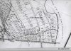
Here is the Hampton Avenue (road) from the Raleigh map. You can see how straight all the avenues are except Hampton Ave. which follows several courses and extends past the Raleigh Land Improvement. Maybe someone better then me could plot the road on one of Boyd's maps. Then we could see exactly where the road is and what the area looks like that it goes through. Scale is 16 chains to an inch. Would be something to find a hidden causeway back there with stone bridges. If it's back there Guy & Jessica will find it. Don

Here is the Hampton Avenue (road) from the Raleigh map. You can see how straight all the avenues are except Hampton Ave. which follows several courses and extends past the Raleigh Land Improvement. Maybe someone better then me could plot the road on one of Boyd's maps. Then we could see exactly where the road is and what the area looks like that it goes through. Scale is 16 chains to an inch. Would be something to find a hidden causeway back there with stone bridges. If it's back there Guy & Jessica will find it. Don
Attachments
I was at that stream along the tracks yesterday morning. The woods are all burnt and I could have easily followed it and looked for a bridge.
Also, I know where the corners are for that Mark Munyon property shown at the top. Bob .. they are the corners we passed through on the hike where we ended up at the Pic. Remember there was a very small amount of property we had to go though to be legal. There was a house right there with people out and we turned and headed the route I plotted out. I should have a photo of the stone or monument we found. I will look for it.
Also, I know where the corners are for that Mark Munyon property shown at the top. Bob .. they are the corners we passed through on the hike where we ended up at the Pic. Remember there was a very small amount of property we had to go though to be legal. There was a house right there with people out and we turned and headed the route I plotted out. I should have a photo of the stone or monument we found. I will look for it.