Where was Davis Grove?

A

anghew025

Guest
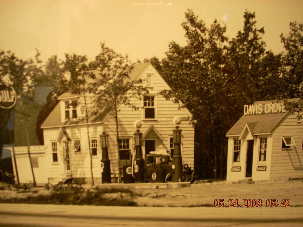
Hi. I'm trying to find out something. My husband has a family picture of a gas station that his great grandfather ran. In the picture there is a building behind the gas pumps on the top of which says, "Davis Grove". My husband was told by his father that Davis Grove is somewhere between 4 mile circle outside of Chatsworth and the Marlton/Medford area along Rt 70. The picture was supossedly taken during the early 1930's. Does anybody know exactly where Davis Grove is/was? Is it an old forgotten town of South Jersey? I've checked all of the maps on here and I'm not seeing it there either. Google returns no results either.
davisgrove.jpg
 

Teegate

Administrator
Site Administrator
Sep 17, 2002
25,951
8,695
That is a great photo and I hope we are able to help you with this. I thought it was the station at Chairville but it isn't it appears.

Jerseyman should have some input on this I hope.

Guy
 

Teegate

Administrator
Site Administrator
Sep 17, 2002
25,951
8,695
Not the same place unless the buildings were replaced.

IMG_5982.JPG


Guy
 
LMCFashions (and Guy):

After spending well over an hour pouring over numerous maps and checking many, many references, I have concluded that the location you seek is in Horsham Township, Montgomery County, Pennsylvania—and probably along the Old York Road there. The Willow Grove Naval Air Station has more or less swallowed up the hamlet of Davis Grove, but it appears your photo dates to the mid or late 1920s and this military installation did not exist at that time.

There are several reasons why I have determined that this filling station is not in New Jersey where you think it stood. First, the Wayne gasoline pumps shown in the photo date to the early or mid-1920s. The gasoline would be manually pumped into the clear reservoir and then dispensed into the motor vehicle by gravity. The reservoir featured cast-in graduated markings to indicate to the attendant and the motorist how much gasoline was being dispensed. With that in mind, the New Jersey State Highway Department did not construct its Route 40 (today’s NJ Route 70) until the early 1930s, which they built in sections. Unless the owner of the filling station purchased the pumps used, they would have installed newer motorized Wayne or Tokheim pumps and not these older models.

Based on the truck in the photograph, I suspect this image *might* be an official Gulf Oil Corporation photo as that is a Gulf Oil Co. truck. Finally, the trees behind the filling station do not look correct for the location you describe, although I could be wrong.

If you can provide any further corroborating evidence of this filling station being along Route 70 somewhere, I would be happen to take a second look. Meanwhile, you might consider visiting the Historical Society of Montgomery County in Norristown, Pennsylvania to see if you can learn more there about this filling station.

Best regards,
Jerseyman

P.S. Thanks for the vote of confidence, Guy!!
 

Teegate

Administrator
Site Administrator
Sep 17, 2002
25,951
8,695
No problem Jerseyman. I was going to mention about the pumps since I worked with a man years ago who used them and would talk about them all the time. I also was going to point out about the black oil line down the road. Years ago before PCV valves there was a tube that would come out of the engine that would allow fumes and oil from the engine to run out it to the ground. The highways would all have that line from this occurring. Modern engines have greatly reduced pollution which we all should really appreciate.

Guy
 

Teegate

Administrator
Site Administrator
Sep 17, 2002
25,951
8,695
A quick alteration. The photo must have been taken with a camera of the photo in a frame.
 

Attachments

  • davisgrove1.jpg
    davisgrove1.jpg
    647.9 KB · Views: 449

bobpbx

Piney
Staff member
Oct 25, 2002
14,661
4,838
Pines; Bamber area
Guy, is that photo you posted from that station East of that Tavern (Indian King?) by the Medford Circle? What age are those pumps, is the price still on the gas in them?
 

Ben Ruset

Administrator
Site Administrator
Oct 12, 2004
7,619
1,878
Monmouth County
www.benruset.com
Guy, is that photo you posted from that station East of that Tavern (Indian King?) by the Medford Circle? What age are those pumps, is the price still on the gas in them?

It's either that one or the one in Jenkins.

If I remember the last price posted on the station in Medford was either $0.89 or $0.99/gal.
 
A

anghew025

Guest
Thanks everyone for all of your help! After speaking with my father-in-law last night, here's a little more of what I do know. Thomas James was his great-grandfather's name (actually making it my husbands great, great grandfather) he was born 7/27/1892 and died 8/1978. Dad said that when his great grandfather was running this station that the state came in and told all of the business owners that they needed to move all of the buildings back in order to make improvements to Rt 70 and that this station was somewhere between Red lion Circle and Medford Circle. Dad also says he has some black and white negatives from the store so we are going to pick them up today and see if we can get them developed. If you look closely at the truck in the picture it isn't a gulf symbol on the side, the logo is coming from something sitting on the ground next to the truck.
 

Teegate

Administrator
Site Administrator
Sep 17, 2002
25,951
8,695
Guy, is that photo you posted from that station East of that Tavern (Indian King?) by the Medford Circle? What age are those pumps, is the price still on the gas in them?

Bob,

The Indian King is in Haddonfield, you are thinking of Indian Chief. In any event, the location of the station I posted the photo of is here.

http://maps.google.com/maps?q=39.89...771&spn=0.003128,0.004501&t=h&z=18&iwloc=addr


The trees to the left is the stream that divides Medford from Southhampton Township. The station is just inside Southhampton Township. Ben is correct that the price was 89 cents per gallon. The price is now gone.

This could be the place if the buildings had to be rebuilt, but that name I have never heard of before. I do not have any maps saying that, and I surmise either does Jerseyman. It is at Chairville which has been around forever, so why would a station there have the name of Davis Grove?

Guy
 

oji

Piney
Jan 25, 2008
2,126
548
63
Browns Mills
I just took an imaginary drive down that section of rt.70 in 1956(without a DeLorean with flux capacitor). Although there was no evedince of the older gas station I did notice Guy's station had a nice little pond next to it but by 1970 there were trees growing in it. BTW the pumps at Guy's Gas and Bakery Outlet have the upgraded hoses and nozzles. What year were they required?
 

Teegate

Administrator
Site Administrator
Sep 17, 2002
25,951
8,695
1975 was the first year for unleaded gas, and the recovery systems started then. Actually, it was the summer of 1974 that this started to be ready for the 1975 models in the fall. I happened to be working at a gas station then and experienced the change from learning about it to the final outcome. Construction was a mess since they had to dig up the property and the pumps.

Guy
 

woodjin

Piney
Nov 8, 2004
4,342
328
Near Mt. Misery
mapstream


LMC, are you certain now that it was between the red lion and Medford? There is an area that has always been curious to me along route 70 between the four mile circle and the red lion. It is on the south side between burrs mill road and sooy place road. I always thought it might have been a gas station because you can tell that there used to be a paved in and out "U" shape. There are ruins in there but I can not recall exactly what of (post 1900 though). Here is a link. If you go to the 1930 photo (accessable from the link) it shows that something was there but the photo quality is to poor to determine what.

Jeff
 
A

anghew025

Guest
Well I'm just going on what dad says and he swears that it was between those 2 places. Your photo isn't appearing though so I can't see :( I would love to see the pic. Can you either email it to me or repost it?
 

gurbanik

New Member
Mar 1, 2007
8
0
Chairville Gas Station

The price is still listed on one side, $1.09 per gallon. I can't remember when it was that cheap but probably between 1990 and 1995? I drive Route 70 from 4 Mile Circle to Chairville every day now, and I don't see anything that resembles the two buildings in the Davis Grove picture. There has been much new development in Medford between Chairville and the prior "Medford Circle" and if there was any other older gas station it could have been demolished long ago.
Geoff
 
A

anghew025

Guest
My biggest thing is why is there no mention whatsoever, anywhere, of a place in NJ called Davis Grove?? Not even on the old maps?? Very curious.
 

Bluetick1

New Member
Dec 3, 2006
10
0
Since I live in the Horsham, Pa. area, the name Davis Grove got me thinking and after some searching, I have to agree with Jerseyman and say it's in (or was) in what is Horsham, Pa. today.

The Willow Grove airbase did it in, they appear to have plowed it under. Unless it's still standing on the base grounds somewhere, I doubt it's there. The immediate area also has a golf course + corporate center with a large wooded area that belongs to the base too, lot's of recent building and posted government property leaves little chance you'd find it.

I did find a reference to it and a small bit of it's history on a blog about the traffic situation around the base + area..." The base's land used to be the hamlet of Davis Grove, a focal point of community life where local residents came to vote, discuss politics and attend community meetings during Revolutionary times.

The hamlet grew up around the intersection of Keith's Road (now called Governor Road) and Privet Road.

The first airstrip there belonged to Harold F. Pitcairn and his Mail Wing, flying from former farms he had purchased. Pitcairn's airport was condemned by the Navy for an air station commissioned in 1943.

Today, there are virtually no signs of the original Davis Grove settlement "...

If you Google map the area, you'll see the roads they refer to and also that there is a Davis Grove road there and how some of the roads run onto the bases property.

If someone could find an old pre '43 aerial map of the area, that might show something interesting.

Hope this helps some.
 
Top