2017-18 Winter weather

Boyd

Administrator
Staff member
Site Administrator
Jul 31, 2004
9,826
3,007
Ben's Branch, Stephen Creek
Here comes the next one...
___________________________________

Hazardous Weather Outlook
National Weather Service Mount Holly NJ
543 AM EDT Sun Mar 11 2018

A rapidly intensifying ocean storm will affect the area with snow or
rain changing to snow, Monday afternoon and night. At this point,
forecast confidence regarding extent of accumulative snow coverage
remains below average. Snow amounts will depend on the storms track
as well as surface temperatures.
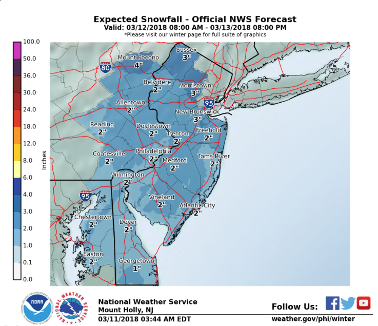
more_snow.png
 

46er

Piney
Mar 24, 2004
8,837
2,144
Coastal NJ
And another right behind it. They are running on a better schedule than Amtrak.

But the disclaimer for Mon/Tues;

"Uncertainty in Snowfall Forecast: 

There is still considerable uncertainty in the track of the storm system."

http://www.weather.gov/media/phi/current_briefing.pdf

Which means it could be worse, or it could be better, or it could be nothing at all :rolleyes:
 
Last edited:

bobpbx

Piney
Staff member
Oct 25, 2002
14,664
4,843
Pines; Bamber area
These are weathermen? I'm going down to the docks and find Larry, he'll give me the forecast.

BTW, was in Greenwood Forest today, and the wind overhead was pulsing rapidly. I have never heard that before. It lasted 20 seconds.
 
Last edited:

Boyd

Administrator
Staff member
Site Administrator
Jul 31, 2004
9,826
3,007
Ben's Branch, Stephen Creek
Where did you see this? Have not noticed anything like that in my part of Atlantic County. I noticed one area (after the first storm with the high winds) where there were a lot of downed trees. But these were all dead trees from the pine beetle outbreak several years ago and they were easily blown down.

Out in my own woods, I had three large oaks go down. But they have been dead for a number of years and I've actually been surprised they survived this long.
 

46er

Piney
Mar 24, 2004
8,837
2,144
Coastal NJ
It's guesstimate time once again. :worms: Pick your door' #1, #2 or #3 :)


US National Weather Service Philadelphia/Mount Holly· 1 hr ·

Here is the latest official snowfall forecast and low-/high-end probability scenarios for the upcoming coastal storm. This will be a long duration event starting in our southern areas late tonight and continuing into Wednesday as it will come in two waves. However, there is growing concern for more substantial snowfall and higher impacts to the region, including travel hazards, coastal flooding and more power outages, with the second wave on Wednesday. However, there is still high uncertainty with the track of the storm, especially for Wednesday (this is why we are emphasizing the different scenarios).

167172093.jpg
 

46er

Piney
Mar 24, 2004
8,837
2,144
Coastal NJ
My latest 'No Miss' forecast from my newly created Take a Guess Weather Service. It could fall in the form of rain, snow, hail, sleet, freezing rain or pollen. ;)

167172114.1zXgf3ri.0_60.jpg
 
  • Like
Reactions: h2ochild

Boyd

Administrator
Staff member
Site Administrator
Jul 31, 2004
9,826
3,007
Ben's Branch, Stephen Creek
Expect it to trend upwards.

It sure did! :eek:

new.png


Hazardous Weather Outlook
National Weather Service Mount Holly NJ
525 AM EDT Mon Mar 19 2018

DEZ003-004-NJZ013-014-020-022>027-200930-
Inland Sussex-Delaware Beaches-Western Monmouth-Eastern Monmouth-
Ocean-Atlantic-Cape May-Atlantic Coastal Cape May-Coastal Atlantic-
Coastal Ocean-Southeastern Burlington-
525 AM EDT Mon Mar 19 2018

This Hazardous Weather Outlook is for southern Delaware, central
New Jersey and southern New Jersey.

.DAY ONE...Today and Tonight.

There is a low probability for widespread hazardous weather.

.DAYS TWO THROUGH SEVEN...Tuesday through Sunday.

A coastal storm will impact the region on Tuesday. A wintry mix is
expected to overspread the area from the south Tuesday morning and
could impact travel during the day, especially north of Atlantic
City, New Jersey where rain is less likely. Strong northeast
winds gusts to 40 mph are expected along the coast.

A second, probably stronger, coastal low is expected to develop
Tuesday night and impact portions of the region on Wednesday. There
is a potential for significant snowfall if the storm tracks close
enough to the area. The combination of heavy wet snow and strong
northeast winds could lead to extensive power outages in this
scenario. However, there is still considerable uncertainty in the
track of the second coastal storm, so please continue to monitor the
latest forecast.

The risk for minor coastal flooding will increase late Tuesday. Minor
to moderate coastal flooding is possible on Wednesday.
 
Top