Boyd's Map of the Pines beta available

Boyd

Administrator
Staff member
Site Administrator
Jul 31, 2004
9,826
3,005
Ben's Branch, Stephen Creek
That's a very valid point, but I spent 37 years as an artist and designer and you can certainly lose your audience with information overload. Finalizing a design is often more about removing the unnecessary elements than adding new ones.

Garmin's handheld units do offer a good selection of menues to control the map appearance, but unfortunately you can't directly influence the display of contour lines. If you set map detail lower, they will disappear at a lower zoom level, but this may also have adverse effects on other map elements. In an ideal world, your point would be right on target, and the software would give the user full control of how to interpret the map data. I can do exactly that with powerful GIS software like Globalmapper or arcPAD, but not on a garmin GPS.

I think there's a way for me to influence at what zoom level the minor contour lines will disappear, but this gets a bit complicated and I haven't experimented with it. That would probably be the best of both worlds - showing all contour lines below .3 miles and dropping the minors at higher levels. In fact, that's how my Nuvi 3790 already behaves by default, but not my Oregon. I'm definitely going to look into this, but probably not for this coming version since it would involve a lot of re-compilation.
 

46er

Piney
Mar 24, 2004
8,837
2,144
Coastal NJ
That's a very valid point, but I spent 37 years as an artist and designer and you can certainly lose your audience with information overload. Finalizing a design is often more about removing the unnecessary elements than adding new ones.

Garmin's handheld units do offer a good selection of menues to control the map appearance, but unfortunately you can't directly influence the display of contour lines. If you set map detail lower, they will disappear at a lower zoom level, but this may also have adverse effects on other map elements. In an ideal world, your point would be right on target, and the software would give the user full control of how to interpret the map data. I can do exactly that with powerful GIS software like Globalmapper or arcPAD, but not on a garmin GPS.

I think there's a way for me to influence at what zoom level the minor contour lines will disappear, but this gets a bit complicated and I haven't experimented with it. That would probably be the best of both worlds - showing all contour lines below .3 miles and dropping the minors at higher levels. In fact, that's how my Nuvi 3790 already behaves by default, but not my Oregon. I'm definitely going to look into this, but probably not for this coming version since it would involve a lot of re-compilation.

I was thinking in a similar direction; have a list of available coutour lines and select from that for a particular map. In my mind detail and countour lines are not in the same categories.

I have a Garmin 545s GPS/chartplotter/sounder that came with the boat. Have not gone thru it all, but it appears the sounder can display the bottom similar to what your LIDAR's look like.
 

Boyd

Administrator
Staff member
Site Administrator
Jul 31, 2004
9,826
3,005
Ben's Branch, Stephen Creek
LIDAR is the way the data is acquired... DEM (digital elevation model) is the type of data. Actually, even the cheapest Nuvi is capable of displaying DEM. Zoom way out and you will see shaded terrain from the basemap. It is very low resolution, so it won't show until you zoom way out.

But if you buy a real garmin topo map, it will show high quality shaded terrain at all zoom levels (you can disable this on a handheld but not on the nuvi). And this gets frustrating. Garmin does not provide any details on their map format so I have to use reverse-engineered 3rd party tools to make maps. Nobody has managed to figure out the data format for the use of DEM in a Garmin map. You need the real Garmin program MPC (Mapsource Product Creator) for that, and Garmin controls it very tightly. They only offer it to their partners, and they won't accept partners in the US since they would compete with their own products.

I wish I could made maps that full use of this great LIDAR DEM data that I have, but it can't be done on Garmin. What I *can* do is make a map that looks like the shaded images I've posted, but it will just be a picture and not a 3d model of the terrain, so you won't be able to derive actual elevations and it won't render in 3d. When I finish this current map project, I will look into ways to make some shaded terrain maps using this data. The challenge will be making them work on older models.
 

Boyd

Administrator
Staff member
Site Administrator
Jul 31, 2004
9,826
3,005
Ben's Branch, Stephen Creek
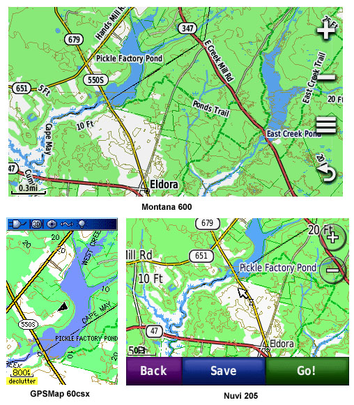
Well it seems like FOREVER, but my new map is finally available for download here: Boyd's Map of New Jersey 2012

This map is actually a first for GPSFileDepot. I've been working with the site owner and a couple other members to develop a "universal version" that can be installed on both the Mac and Windows from a single download. This has the potential to save a lot of disk space for GPSFileDepot, since there are separate files for Mac and PC now.

Let me know how it works for you, it just went live a few minutes ago and there may be some glitches since the website software had to be updated to recognize this new universal format. Happy exploring everyone, this is an early Christmas present. :D

screenshots.jpg
 
  • Like
Reactions: pinelandpaddler

Pan

Explorer
Jul 4, 2011
583
265
Arizona
I wish I had such an awesome thing as this back in the days when I prowled those wonderful woods. All I had was a gas station road map and geological survey maps that I purchased, the latter often last updated in 1898.
 

Boyd

Administrator
Staff member
Site Administrator
Jul 31, 2004
9,826
3,005
Ben's Branch, Stephen Creek
I love paper maps, which is why I got interested in GPS and cartography in the first place. As a little boy I could stare at a map for hours and try to imagine what it represented. I got my first GPS in 2002 (a Magellan Meridian Gold), which seems like a lifetime for some reason today. This is what's left of one of my favorite paper maps, a USGS 100k topo that went many miles in my back pocket. :D

oldmap01.jpg


I have a big box of other maps, and several large mailing tubes up in the attic with USGS paper maps rolled up inside. Awhile ago I found this NJ road map from 1939 in an antique store, and it's on my wall next to a 19th century map of Atlantic County.

oldmap02.jpg
 

Teegate

Administrator
Site Administrator
Sep 17, 2002
25,951
8,695
I have that same map Boyd (Hammonton). That is a good map.

Guy
 

Boyd

Administrator
Staff member
Site Administrator
Jul 31, 2004
9,826
3,005
Ben's Branch, Stephen Creek
I have that same map Boyd (Hammonton). That is a good map.

Yeah, I was really excited when I got that (from the old map store that used to be in the plaza with TGI Fridays near the Marlton Circle). I especially liked the fan-fold format instead of a "wall map", perfect for carrying around and the 100k scale covered a good chunk of the pines.

Of course, a 100k map isn't all that accurate. It is comparable to Garmin's old US Topo (now called their 100k topo). The USGS 24k maps have about 16x the detail (you would need 4 x 4 of them to cover the same area). My new map is probably about 12k resolution, which would represent 64x more detail than that old 100k topo and of course it covers all of NJ instead of one quad.

I never would have imagined we could have something like that to carry around, not to mention aerial photography at about 2 feet per pixel resolution with "BirdsEye".
 

46er

Piney
Mar 24, 2004
8,837
2,144
Coastal NJ
Thanks Boyd, truly appreciate it.

I'm not sure about this, but it appears Garmin has relaxed the size restriction they had for downloading Birdseye in Basemap. I've been downloading some big files, over 200mb over the past 2 weeks.
 

Teegate

Administrator
Site Administrator
Sep 17, 2002
25,951
8,695
Thanks Boyd, truly appreciate it.

I'm not sure about this, but it appears Garmin has relaxed the size restriction they had for downloading Birdseye in Basemap. I've been downloading some big files, over 200mb over the past 2 weeks.

After all the time I spent downloading them:bang:
 

ecampbell

Piney
Jan 2, 2003
2,889
1,029
I am now an enthusiastic owner of a 450.
Can you provide some guidance on Garmin's Birdseye imagery?
Do you like it?
Do I need to add memory and how much will the 450 support?
I have loaded Boyd's New Jersey and Wharton 1995.
From what I can tell the 450 has 1 G of internal memory.

Thanks,
Ed
 

Teegate

Administrator
Site Administrator
Sep 17, 2002
25,951
8,695
I am now an enthusiastic owner of a 450.
Can you provide some guidance on Garmin's Birdseye imagery?
Do you like it?
Do I need to add memory and how much will the 450 support?
I have loaded Boyd's New Jersey and Wharton 1995.
From what I can tell the 450 has 1 G of internal memory.

Thanks,
Ed

Ed,

Congrats Ed! It will take a little time to get use to it. You need to buy the biggest card you can find. I have an 8GIG and I would suggest you buy that or bigger if available. You will need almost 4GIG just to download all of the Birdseye maps of NJ in high resolution. If you use the aerials you can't use the topo as far as I know.

I would suggest you subscribe to Birdseye because having the aerial maps in the unit is great. When you get it up and running and you feel comfortable send me an email and I can tell you something. EDIT: I see you have Wharton 1995 so no need to email me. In my unit the 1997 aerials work in the Wharton area until I zoom in closer and then the Wharton 1995 kicks in which is exactly how I like it.

Edit again: Actually, I only have the bottom half of NJ in high resolution and it takes up quite a bit of my card.

Guy
 

Boyd

Administrator
Staff member
Site Administrator
Jul 31, 2004
9,826
3,005
Ben's Branch, Stephen Creek
You need to buy the biggest card you can find. I have an 8GIG and I would suggest you buy that or bigger if available.

Guy, I used to feel this way also and got a 16GB class 2 card on which I put over 14GB of Birdseye. But when that card is in the GPS, it takes a LONG time to start up. When I got my Montana, it also took a long time for startup so I got a 16GB class 10 card and put all the files there. Maybe startup was a bit faster, but still very slow (like a minute maybe?). I find that very frustrating, especially if the unit crashes and needs to be restarted. So now I just use a small card and only put the birdseye areas I need on it. This results in much faster startup times.

Ed: congratulations, I hope the new GPS helps with your explorations of the Pines! Before you buy Birdseye, be sure to register your GPS at Garmin. You will receive a coupon for a 10% discount that can be used to lower the subscription cost to $27. There have been some issues with Birdseye in the past where downloaded imagery had poor quality even when you chose highest quality. This was last summer, and I thought it had been corrected but it's not quite clear now whether that's the case. See: http://forums.gpsreview.net/viewtopic.php?t=24582

Let us know if you have any other questions :)
 

manumuskin

Piney
Jul 20, 2003
8,673
2,586
60
millville nj
www.youtube.com
Well it seems like FOREVER, but my new map is finally available for download here: Boyd's Map of New Jersey 2012

This map is actually a first for GPSFileDepot. I've been working with the site owner and a couple other members to develop a "universal version" that can be installed on both the Mac and Windows from a single download. This has the potential to save a lot of disk space for GPSFileDepot, since there are separate files for Mac and PC now.

Let me know how it works for you, it just went live a few minutes ago and there may be some glitches since the website software had to be updated to recognize this new universal format. Happy exploring everyone, this is an early Christmas present. :D

screenshots.jpg
I could relat a personal experience at Pickle Pond as a young man but for decency reasons I won't:) Those were the days:)
 

46er

Piney
Mar 24, 2004
8,837
2,144
Coastal NJ
Guy, I used to feel this way also and got a 16GB class 2 card on which I put over 14GB of Birdseye. But when that card is in the GPS, it takes a LONG time to start up. When I got my Montana, it also took a long time for startup so I got a 16GB class 10 card and put all the files there. Maybe startup was a bit faster, but still very slow (like a minute maybe?). I find that very frustrating, especially if the unit crashes and needs to be restarted. So now I just use a small card and only put the birdseye areas I need on it. This results in much faster startup times.

I decided when I first started to download stuff, to use a separate memory card for each state, so far I have 5 and don't expect more. I've not needed anything larger than a 4GB, which can be found on sale fairly cheap. I keep them in a card wallet, as I do the ones I use for the camera. So far I have never needed to have more than one state loaded at a time.
 

Pan

Explorer
Jul 4, 2011
583
265
Arizona
I love paper maps...

I love GPS. I used to have to spend so much time plotting out complicated routes with paper maps ("turn left (east) on 3rd street; turn R(S) on 2nd big street - right after Avenue X but before Soandso Street...") or trying to figure out where I was.
 
Top